Apollinaris Mons
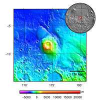 Topography map of Apollinaris Mons | |
| Coordinates | 9°18′S 174°24′E / 9.3°S 174.4°ECoordinates: 9°18′S 174°24′E / 9.3°S 174.4°E[1] |
|---|---|
| Peak | 5 km |
Apollinaris Mons[1] is an ancient shield volcano in the southern hemisphere of Mars. It is situated near the equator, south of Elysium Planitia and north of Gusev crater. Elysium Planitia separates it from the volcanic province of Elysium to its northwest. The volcano's caldera is named Apollinaris Patera;[2] this name formerly applied to the whole edifice.
Apollinaris Mons is about 5 kilometres high with a base about 296 kilometres in diameter.[3] On the top of this volcano is a caldera about 80 km (50 miles) in diameter. The volcano is approximately 3 billion[4] to 3.5 billion years old.[5]
It was named in 1973 after a mountain spring near Rome in Italy.
A study using a global climate model found that the Medusae Fossae Formation could have been formed from ash from Apollinaris Mons, Arsia Mons, and possibly Pavonis Mons.[6]
Gallery
.jpg) False-color Mars Global Surveyor image of Apollinaris Patera. White clouds can be seen hovering above the volcano.
False-color Mars Global Surveyor image of Apollinaris Patera. White clouds can be seen hovering above the volcano.
Interactive Mars map
See also
References
- 1 2 "Apollinaris Mons". Gazetteer of Planetary Nomenclature. USGS Astrogeology Science Center. Retrieved 2012-06-30.
- ↑ "Apollinaris Patera". Gazetteer of Planetary Nomenclature. USGS Astrogeology Science Center. Retrieved 2012-06-30.
- ↑ Google Mars
- ↑ APOD: May 13, 1999 - Mars Volcano Apollinaris Patera
- ↑ 23. Apollinaris Patera Elysium Planitia, Mars
- ↑ Kerber L., et al. 2012. The disporsal of pyroclasts from ancient explosive volcanoes on Mars: Implications for the friable layered deposits. Icarus. 219:358-381.