Thermokarst
Thermokarst is a land surface characterised by very irregular surfaces of marshy hollows and small hummocks formed as ice-rich permafrost thaws, that occurs in Arctic areas, and on a smaller scale in mountainous areas such as the Himalayas and the Swiss Alps. These pitted surfaces resemble those formed by solution in some karst areas of limestone, which is how they came to have karst attached to their name without the presence of any limestone. Small domes that form on the surface due to frost heaving with the onset of winter are only temporary features. They then collapse with the arrival of next summer's thaw and leave a small surface depression. Some ice lenses grow and form larger surface hummocks, which last many years and sometimes become covered with grasses and sedges, until they begin to thaw. These domed surfaces eventually collapse either annually or after longer periods and form depressions which contribute to uneven surfaces. These are included within the general label of thermokarst.
The Batagaika crater in Siberia is an example of a large thermokarst depression.
Thaw lakes
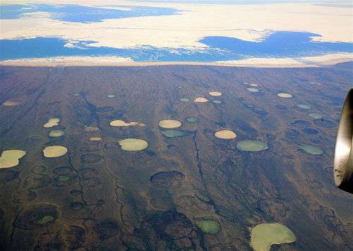
The related term thermokarst lake, also called a thaw lake, tundra lake, thaw depression, or tundra pond,[1] refers to a body of freshwater, usually shallow, that is formed in a depression formed by thawing ice-rich permafrost.[2] Continued thawing of the permafrost substrate can lead to the drainage and eventual disappearance of thermokarst lakes, leaving them, in such cases, a geomorphologically temporary phenomenon, formed in response to a warming climate[3] Thermokarst lakes tend to form and disappear in a cyclical manner, resulting in a predictable life cycle (see “Life Cycles” below). These lakes are typically found in arctic and subarctic lowlands, including the western Canadian Arctic[4](e.g. Banks Island, Victoria island), the Alaskan coastal plain,[5][6] interior Yukon territory [7] and the alluvial lowlands of northern Eurasia and Siberia.[8][9][10][11] The presence of thaw lakes in a region results in a thermal disturbance as the water warms the ground. The depth of permafrost below a lake will generally be shallower and if the lake is of sufficient depth, a talik is present. The general morphology (shape, depth, circumference) is variable, with some thaw lakes oriented, meaning they are generally elongated in a specific direction. Though their formation mechanism has not been definitively proven, it is believed to be related to the prevailing winds or storms.[12] The disturbance (of either nature) leads to overall warming and melting of ground ice, after which surface subsidence occurs allowing for water infiltration of either surface water or melted ground ice[13]
Life cycle
Initiation
The initiation of a thaw lake begins with the degradation of ice-rich permafrost. Permafrost degradation is typically linked to a surface disturbance, either natural or artificial, in combination with site-specific factors, such as permafrost ice-content, ground temperature, etc.[14]
Development/expansion
Development of thaw lakes tends to be slow at first, but once the average lake bottom temperature exceeds 0 °C the lake ceases freezing to the bottom and thaw becomes continuous. The lake grows as ice thaws, which may result in the slumping of shorelines or submergence of vegetation, which is why thaw lakes in the boreal forest tend to be surrounded by “drunken trees”.[15] If lakes form in an area of ice-rich permafrost, coalescence of several smaller lakes may occur, producing a larger body of water, magnifying the thermal disturbance. Development may be further facilitated by lateral bank erosion.[16]
Drainage
Before complete drainage, lake edges recede through retrogressive thaw slumping and subaerial debris flows. Actual drainage may be triggered by fluvial erosion or expansion of adjacent basins at inland locations. In coastal areas, drainage may be due to coastal retreat leading to thermal abrasion or erosion due to wave action. More gradual drainage (partial or complete) may be caused by local permafrost degradation and erosion.[17] Lakes stop growing once drainage initiated, and eventually depressions are filled by sediments, aquatic plants or peat. Another option for the fate of a drained thaw lake is that the active layer surrounding the lake deepens to below water level once ground ice is exhausted, allowing for a residual lake to remain.[18]
The formation of permafrost thaw lakes due to warming climate is a positive feedback loop, as methane and carbon dioxide are released as permafrost thaws, contributing to further climate warming[19]
See also
References
- ↑ Black, R.F (1969). "Thaw depressions and thaw lakes; a review". Biuletyn Peryglacjalny. 19: 131–150.
- ↑ Bucksch, Herbert. Dictionary Geotechnical Engineering. New York, Springer, 1997.
- ↑ Phillips, M., Arenson, L.U., Springman, S.M. (2003). "Permafrost". In Proceedings of the Eighth International Conference on Permafrost, 21–25 July 2003, Zurich Switzerland: 660.
- ↑ Mackay (1963). "The Mackenzie Delta area". Geographical Branch Memoir. 8: 202.
- ↑ Hinkel, K. M., Frohn, R. C., Nelson, F. E., Eisner,W. R., Beck, R. A. (2005). "Morphometric and spatial analysis of thaw lakes and drained thaw-lake basins in the Western Arctic Coastal Plain, Alaska". Permafrost and Periglacial Processes. 16: 327–342.
- ↑ Sellmann, P.V., Brown, J., Lewellen, R.I., McKim, H. and Merry, C. (1975). "The classification and geomorphic implications of thaw lakes on the Arctic Coastal Plain, Alaska". COLD REGIONS RESEARCH AND ENGINEERING LAB HANOVER NH.
- ↑ Burn, C. R., Smith, M.W. (1988). "Thermokarst lakes at Mayo, Yukon Territory, Canada". In Senneset, K., ed., Permafrost, Proceedings of the Fifth International Conference on Permafrost, 2–5 August 1988, Tapir Trondheim: 700–705.
- ↑ Dostovalov, B. N., Kudryavtsev, V. A. (1967). "Obshcheye mierzlotovedeniya". Moscow State University: 463.
- ↑ Morgenstern, A., Grosse, G., Fedorova, I., Schirrmeister, L. (2011). "Spatial analysis of thermokarst lakes and basins in Yedoma landscapes of the Lena Delta". The Cryosphere. 5: 849–867.
- ↑ Romanovskii, N. N., Hubberten, H.-W., Gavrilov, A. V., Tumskoy, V. E., Tipenko, G. S., Grigoriev, M. N. (2000). "Thermokarst and land–ocean interactions, Laptev Sea region, Russia". Permafrost and Periglacial Processes. 11: 137–152.
- ↑ Tomirdiaro, S. V., Ryabchun, V. K. (1978). "Lake thermokarst on the Lower Anadyr Lowland". In Permafrost: USSR Contribution to the Second International Conference, Yakutsk, USSR. Washington, DC, National Academy of Sciences: 94–100.
- ↑ French, H.M. (2018). The periglacial environment. John Wiley & Sons Ltd.
- ↑ Grosse, G., Jones, B. and Arp, C. (2013). "Thermokarst lakes, drainage, and drained basins".
- ↑ Burn, C.R. and Lewkowicz, A.G. (1990). "Canadian landform examples‐17 retrogressive thaw slumps". The Canadian Geographer/Le Géographe canadien. 34 (3): 273–276.
- ↑ Burn, C.R. and Lewkowicz, A.G. (1990). "Canadian landform examples‐17 retrogressive thaw slumps". The Canadian Geographer/Le Géographe canadien. 34 (3): 273–276.
- ↑ French, H.M. (2018). The periglacial environment. John Wiley & Sons Ltd.
- ↑ Grosse, G., Jones, B. and Arp, C. (2013). "Thermokarst lakes, drainage, and drained basins".
- ↑ Burn, C.R. and Lewkowicz, A.G. (1990). "Canadian landform examples‐17 retrogressive thaw slumps". The Canadian Geographer/Le Géographe canadien. 34 (3): 273–276.
- ↑ Van Huissteden, J., Berrittella, C., Parmentier, F.J.W., Mi, Y., Maximov, T.C. and Dolman, A.J. (2011). "Methane emissions from permafrost thaw lakes limited by lake drainage". Nature Climate Change. 1 (2): 119.