Dawes (Martian crater)
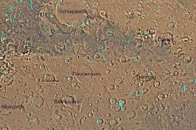
 Location of Dawes Crater. | |
| Planet | Mars |
|---|---|
| Region | Sinus Sabaeus quadrangle |
| Coordinates | 9°12′S 38°00′E / 9.2°S 38°E[1]Coordinates: 9°12′S 38°00′E / 9.2°S 38°E[1] |
| Diameter | 191 km |
| Eponym | William Rutter Dawes |
Dawes Crater is located in the Sinus Sabaeus quadrangle of Mars, at 9.2 S and 38 E.[1] It is about 191 km (119 mi) in diameter, and was named after William R. Dawes, a British astronomer (1799–1868)[2] who was ahead of his time in believing that Mars only had a thin atmosphere. Dawes presumed that the atmosphere of Mars was thin because surface markings on the planet could easily be seen.[3]
Other nearby prominent craters include the gigantic Huygens to the east, Teisserenc de Bort further to the northeast, Denning to the southwest and Pollack more than 1,000 km west. Nearly east of the crater is Tisia Valles.
Description
The crater depth is about 4,000 meters from top. It also has a small crater to the northeast with the elevation of about 3,000 meters below mean level and has a small central hill. Dawes crater is located in the highest area of Terra Sabaea and has the deepest single crater in the area and also one of the deepest that include multiple craters.
Impact craters generally have a rim with ejecta around them, in contrast volcanic craters usually do not have a rim or ejecta deposits. As craters get larger (greater than 10 km in diameter) they usually have a central peak.[4] The peak is caused by a rebound of the crater floor following the impact.[5] Sometimes craters expose layers that were buried. Rocks from deep underground are tossed onto the surface. Hence, craters can show us what lies deep under the surface.
Names
The crater is named for the British astronomer William Rutter Dawes, it was given the name by the IAU in 1973 and were its first named craters,[1] one of the names where it was named in one of the earlier features first mentioned in Proctor's map, "Dawes Ocean". The first named feature after Dawes were "Dawes Continent", "Dawes Ocean" , "Dawes Sea" , "Dawes Furnee Bay" and "Dawes Strait", first appeared in Richard Proctor's 1867 map.[6] Names like "Dawes Ocean" and "Dawes Furnee Bay" were mentioned in Nathaniel Green's 1877 map[7] while "Dawes Continent" became "Beer Continent" what is now Arabia Terra and Tyrrhena Terra, Dawes Sea was later another name, which it became Oenotria and is now Oenotria Plana and Dawes Strait was not mentioned, . After these earlier names became obsolete in the early 20th century, first named by Giovanni Schiaparelli, "Dawes Ocean" became "Solis Pons" and is now the south of Terra Sabaea, "Dawes Furnee Bay" became "Festigium Aryn" which is now Meridiani Planum and "Dawes, later it became Syrtis Major and is now Syrtis Major Planum.
Images
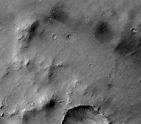
 Part of Dawes Crater showing eroding wall on left and dunes on crater floor on the right. Picture taken with CTX camera (on Mars Reconnaissance Orbiter).
See also
- List of craters on Mars: A-G
- List of people with craters on Mars named after them
- Ore resources on Mars
- Planetary nomenclature
References
- 1 2 3 4 "Dawes". Gazetteer of Planetary Nomenclature. USGS Astrogeology Research Program.
- ↑ "Gazetteer of Planetary Nomenclature". Mars. USGS.
- ↑ Glasstone, S. (1968). The Book of Mars. Washington D.C.: NASA. .
- ↑ http://www.lpi.usra.edu/publications/slidesets/stones/
- ↑ Hugh H. Kieffer (1992). Mars. University of Arizona Press. ISBN 978-0-8165-1257-7. Retrieved 7 March 2011.
- ↑ An early map of the planet Mars, by Richard A. ProctorOther World than Ours, Fourth Edition (1905), p. 85-87
- ↑ "Map of Mars drawn by Nathaniel Everett Green in 1877".