Rudaux (crater)

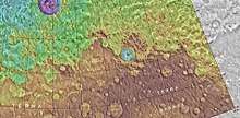
MOLA map showing Rudaux Crater, and other nearby craters. Colors show elevations.
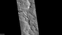
West rim of Rudaux Crater, as seen by CTX camera (on Mars Reconnaissance Orbiter).

Rudaux is an impact crater in the Ismenius Lacus quadrangle of Mars, located at 38.3°N latitude and 309.1°W longitude. It measures 107 kilometers in diameter and was named after French artist and astronomer Lucien Rudaux. The naming was approved by the IAU's Working Group for Planetary System Nomenclature in 1973.[1]

Interactive Mars map

Acidalia PlanitiaAcidalia PlanitiaAlba MonsAmazonis PlanitiaAonia TerraArabia TerraArcadia PlanitiaArcadia PlanitiaArgyre PlanitiaElysium MonsElysium PlanitiaHellas PlanitiaHesperia PlanumIsidis PlanitiaLucas PlanumLyot (crater)Noachis TerraOlympus MonsPromethei TerraRudaux (crater)Solis PlanumTempe TerraTerra CimmeriaTerra SabaeaTerra SirenumTharsis MontesUtopia PlanitiaValles MarinerisVastitas BorealisVastitas BorealisMap of Mars
The image above contains clickable linksInteractive imagemap of the global topography of Mars. Hover your mouse to see the names of over 25 prominent geographic features, and click to link to them. Coloring of the base map indicates relative elevations, based on data from the Mars Orbiter Laser Altimeter on NASA's Mars Global Surveyor. Reds and pinks are higher elevation (+3 km to +8 km); yellow is 0 km; greens and blues are lower elevation (down to −8 km). Whites (>+12 km) and browns (>+8 km) are the highest elevations. Axes are latitude and longitude; Poles are not shown.
(See also: Mars Rovers map) (view • discuss)

See also

References

  1. "Gazetteer of Planetary Nomenclature | Rudaux". usgs.gov. International Astronomical Union. Retrieved 4 March 2015.
This article is issued from Wikipedia. The text is licensed under Creative Commons - Attribution - Sharealike. Additional terms may apply for the media files.