Phillips (Martian crater)
 Topographic location of Phillips Crater | |
| Planet | Mars |
|---|---|
| Coordinates | 66°42′S 45°06′W / 66.7°S 45.1°WCoordinates: 66°42′S 45°06′W / 66.7°S 45.1°W |
| Diameter | 190.2 km |
| Eponym | John Phillips and Theodore E. Philips |
Phillips Crater is a crater in the Mare Australe quadrangle of Mars, located at 66.7° south latitude and 45.1° west longitude. It is 190.2 km in diameter and was named after John Phillips, a British geologist (1800–1874), and Theodore E. Philips, a British astronomer (1868–1942).[1] The northernmost rim is in the Argyre quadrangle.
Nearby prominent craters include Maraldi to the east-northeast, the half-eroded du Toit to the west-southwest and Von Kármán to the west. Hundreds of kilometers to the north is Surius Vallis. Also the crater is in the area where the sun shines 24 Martian hours during the summer solstice and all day dark during the winter solstice, as the vicinity is crossed by the Southern (or the Martian Antarctic) Circle which is around the northern part.
Description
The crater includes a smaller crater which was created by a separate impact. In that location, there are three unnamed craters, two attached in the northwest with a small central hill in the second one and another in the east not far from the crater center.
In this area one can often see polygons. Polygonal, patterned ground is quite common in some regions of Mars.[2][3][4][5][6][7][8] It is commonly believed to be caused by the sublimation of ice from the ground. Sublimation is the direct change of solid ice to a gas. This is similar to what happens to dry ice on the Earth. Places on Mars that display polygonal ground may indicate where future colonists can find water ice. Patterned ground forms in a mantle layer, called latitude dependent mantle, that fell from the sky when the climate was different.[9][10][11][12]
Names
The crater are named for the British geologist John Phillips and the British astronomer Theodore E. Phillips it was given the name by the IAU in 1973 and were its first named craters.[1] The first named feature after Phillips was "Phillips Sea" it was named in Richard Proctor's 1867 map.[13] near the exact location of the crater now Phillips, the sea name was obsolete in the early 20th century, it covered what would later become "Mare Australe" named by Giovanni Schiaparelli and was the name for several decades, parts of what are now Argentea Planum and Sisyphi Planum. In Nathaniel Green's 1877 map, another feature after Phillips was named "Phillips Island",[14] it would later be called Memnonia and Zephyria, it covered what are now the Memnonia and Aeolis quadrangles, and most of Terra Sirenum.
Gallery
The enlarged pictures below shows these features.
 Phillips Crater as seen by CTX camera (on Mars Reconnaissance Orbiter).
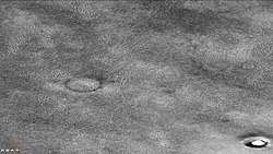 Phillips Crater showing polygons with ice in cracks between polygons, as seen by CTX camera (on Mars Reconnaissance Orbiter). Note this is an enlargement of a previous image.
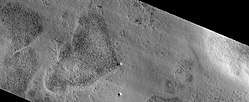 Phillips Crater Area, as seen by HiRISE.
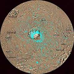 Map of Mare Australe quadrangle with major features labeled.
See also
References
- 1 2 "Gazetteer of Planetary Nomenclature | Phillips". usgs.gov. International Astronomical Union. Retrieved 4 March 2015.
- ↑ http://www.diss.fu-berlin.de/diss/servlets/MCRFileNodeSe rvlet/FUDISS_derivate_000000003198/16_ColdClimateLandforms-13-utopia.pdf?hosts=
- ↑ Kostama, V.-P., M. Kreslavsky, Head, J. 2006. Recent high-latitude icy mantle in the northern plains of Mars: Characteristics and ages of emplacement. Geophys. Res. Lett. 33 (L11201). doi:10.1029/2006GL025946. K>
- ↑ Malin, M., Edgett, K. 2001. Mars Global Surveyor Mars Orbiter Camera: Interplanetary cruise through primary mission. J. Geophys. Res. 106 (E10), 23429–23540.
- ↑ Milliken, R., et al. 2003. Viscous flow features on the surface of Mars: Observations from high-resolution Mars Orbiter Camera (MOC) images. J. Geophys. Res. 108 (E6). doi:10.1029/2002JE002005.
- ↑ Mangold, N. 2005. High latitude patterned grounds on Mars: Classification, distribution and climatic control. Icarus 174, 336–359.
- ↑ Kreslavsky, M., Head, J. 2000. Kilometer-scale roughness on Mars: Results from MOLA data analysis. J. Geophys. Res. 105 (E11), 26695–26712.
- ↑ Seibert, N., J. Kargel. 2001. Small-scale martian polygonal terrain: Implications for liquid surface water. Geophys. Res. Lett. 28 (5), 899–902. S
- ↑ Hecht, M. 2002. Metastability of water on Mars. Icarus 156, 373–386
- ↑ Mustard, J., et al. 2001. Evidence for recent climate change on Mars from the identification of youthful near-surface ground ice. Nature 412 (6845), 411–414.
- ↑ Kreslavsky, M.A., Head, J.W., 2002. High-latitude Recent Surface Mantle on Mars: New Results from MOLA and MOC. European Geophysical Society XXVII, Nice.
- ↑ Head, J.W., Mustard, J.F., Kreslavsky, M.A., Milliken, R.E., Marchant, D.R., 2003. Recent ice ages on Mars. Nature 426 (6968), 797–802.
- ↑ An early map of the planet Mars, by Richard A. ProctorOther World than Ours, Fourth Edition (1905), p. 85-87
- ↑ "Map of Mars drawn by Nathaniel Everett Green in 1877".
External links
