Charitum Montes
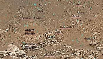 Map of Argyre quadrangle with major features labeled. Galle crater looks like a smile. | |
| Location | Argyre quadrangle |
|---|---|
| Coordinates | 58°24′S 40°17′W / 58.4°S 40.29°WCoordinates: 58°24′S 40°17′W / 58.4°S 40.29°W |
| Length | 850 km |
| Discoverer | Mariner program |
| Naming | Classical albedo feature |
Charitum Montes is a large group of mountains in the Argyre quadrangle of Mars, located at 58.4° south latitude and 40.29° west longitude. It is 850 km across and was named after a classical albedo feature name.[1]
The ranges are semicircular and dominates the area south of Argyre Planitia, it starts at the vicinity of the Thaumasia quadrangle south of Halley all the way to Galle crater.. Two valles (valleys) Surius and Dzigai crosses into the mountain range within the center, another valley crosses the east and is Pallacopas Vallis, both made out of ancient water flows. Craters next to the ranges include Galle and Kamloops to the northeast. Other craters located in the vicinity are the smaller Bentham and Lodwar to the north and Maraldi further south-southeast.
Smaller mountains north of the ranges include Chalce Montes, and Octantis and Oceanidum Montes. Also nrth are the tiny ridges of Charis Dorsum as well as Auxo, Posithea, Hegemone and Cleia.
.jpg)
Gullies
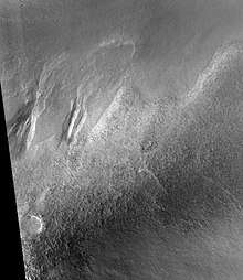
Gullies are common in some latitude bands on Mars. Usually, gullies are found on the walls of craters or troughs, but Charitum Montes has gullies in some areas. Gullies occur on steep slopes, especially craters.
Gullies occur on steep slopes, especially craters. Gullies are believed to be relatively young because they have few, if any craters, and they lie on top of sand dunes which are young. Usually, each gully has an alcove, channel, and apron. Although many ideas have been put forward to explain them, the most popular involve liquid water either coming from an aquifer or left over from old glaciers.[2]
There is evidence for both theories. Most of the gully alcove heads occur at the same level, just as one would expect of an aquifer. Various measurements and calculations show that liquid water could exist in an aquifer at the usual depths where the gullies begin.[3] One variation of this model is that rising hot magma could have melted ice in the ground and caused water to flow in aquifers. Aquifers are layer that allow water to flow. They may consist of porous sandstone. This layer would be perched on top of another layer that prevents water from going down (in geological terms it would be called impermeable). The only direction the trapped water can flow is horizontally. The water could then flow out onto the surface when it reaches a break, like a crater wall. Aquifers are quite common on Earth. A good example is "Weeping Rock" in Zion National Park Utah.[4]
On the other hand, much of the surface of Mars is covered by a thick smooth mantle that is thought to be a mixture of ice and dust. This ice-rich mantle, a few yards thick, smoothes the land, but in places it has a bumpy texture, resembling the surface of a basketball. Under certain conditions the ice could melt and flow down the slopes to create gullies. Because there are few craters on this mantle, the mantle is relatively young.
Changes in Mars's orbit and tilt cause significant changes in the distribution of water ice from polar regions down to latitudes equivalent to Texas. During certain climate periods, water vapor leaves polar ice and enters the atmosphere. The water comes back to ground at lower latitudes as deposits of frost or snow mixed generously with dust. The atmosphere of Mars contains a great deal of fine dust particles. Water vapor will condense on the particles, then fall down to the ground due to the additional weight of the water coating. When ice at the top of the mantling layer goes back into the atmosphere, it leaves behind dust, which insulating the remaining ice.[5]
For years, many believed that gullies were formed by running water, but further observations demonstrate that they may be formed by dry ice. Recent studies describe using the High Resolution Imaging Science Experiment (HiRISE) camera on MRO to examine gullies at 356 sites, starting in 2006. Thirty-eight of the sites showed active gully formation. Before-and-after images demonstrated the timing of this activity coincided with seasonal carbon dioxide frost and temperatures that would not have allowed for liquid water. When dry ice frost changes to a gas, it may lubricate dry material to flow especially on steep slopes.[6][7][8] In some years frost, perhaps as thick as 1 meter, triggers avalanches. This frost contains mostly dry ice, but also has tiny amounts of water ice.[9]
References
| Wikimedia Commons has media related to Charitum Montes. |
- ↑ "Charitum Montes". Gazetteer of Planetary Nomenclature. USGS Astrogeology Research Program.
- ↑ Heldmann, J. and M. Mellon. Observations of Martian gullies and constraints on potential formation mechanisms. 2004. Icarus. 168: 285-304.
- ↑ Heldmann, J. and M. Mellon. 2004. Observations of Martian gullies and constraints on potential formation mechanisms. Icarus. 168:285-304
- ↑ Harris, A and E. Tuttle. 1990. Geology of National Parks. Kendall/Hunt Publishing Company. Dubuque, Iowa
- ↑ MLA NASA/Jet Propulsion Laboratory (2003, December 18). Mars May Be Emerging From An Ice Age. ScienceDaily. Retrieved February 19, 2009, from https://www.sciencedaily.com/releases/2003/12/031218075443.htmAds by GoogleAdvertise
- ↑ http://www.jpl.nasa.gov/news/news.php?release=2014-226
- ↑ http://hirise.lpl.arizona.edu/ESP_032078_1420
- ↑ http://www.space.com/26534-mars-gullies-dry-ice.html
- ↑ http://spaceref.com/mars/frosty-gullies-on-mars.html
See also
External links
| Geography | |||||||||
|---|---|---|---|---|---|---|---|---|---|
| Astronomy |
| ||||||||
| Exploration |
| ||||||||
| Related | |||||||||
| |||||||||