Elysium Mons
 2001 Mars Odyssey THEMIS daytime infrared image mosaic | |
| Coordinates | 25°01′N 147°13′E / 25.02°N 147.21°ECoordinates: 25°01′N 147°13′E / 25.02°N 147.21°E[1] |
|---|---|
| Peak |
13.9 kilometres (46,000 ft) above plains 16 kilometres (52,000 ft) above datum |
| Discoverer | Mariner 9 |
Elysium Mons is a volcano on Mars located in the volcanic province Elysium, at 25°01′N 147°13′E / 25.02°N 147.21°E, in the Martian eastern hemisphere. It stands about 13.9 km (46,000 ft) above the surrounding lava plains, and about 16 km (52,000 ft) above the Martian datum. Its diameter is about 240 km (150 mi), with a summit caldera about 14 km (8.7 mi) across. It is flanked by the smaller volcanoes Hecates Tholus to the northeast, and Albor Tholus to the southeast.
Discovery
Elysium Mons was discovered in 1972 in images returned by the Mariner 9 orbiter.
Terrestrial analog
The terrestrial volcano Emi Koussi (in Chad) has been studied as an analog of Elysium Mons. The two shield volcanoes have summit calderas of similar size, but Elysium Mons is 3.5 times larger in diameter and 6 times higher than its counterpart on Earth.
Possible source of nakhlites
A 6.5 km diameter crater at 29.674 N, 130.799 E, in the volcanic plains to the northwest of Elysium Mons has been identified as a possible source for the nakhlite meteorites, a family of similar basaltic Martian meteorites with cosmogenic ages of about 10.7 Ma, suggesting ejection from Mars by a single impact event. The dates of the igneous rocks of the nakhlites range from 1416 ± 7 Ma to 1322 ± 10 Ma. These dates plus the crater dimensions suggest a growth rate of the source volcano during that interval of 0.4–0.7 m per Ma, far slower than would be expected for a terrestrial volcano. This implies that Martian volcanism had slowed greatly by that point in history.[2]
Gallery
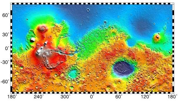
 Topography of the Elysium Mons area, from MOLA
 Mars Global Surveyor view of the summit area
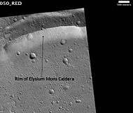 Rim of Elysium Mons caldera, as seen by HiRISE
Interactive Mars map
See also
References
- ↑ "Elysium Mons". Gazetteer of Planetary Nomenclature. USGS Astrogeology Research Program.
- ↑ Cohen, B. E.; Mark, D. F.; Cassata, W. S.; Lee, M. R.; Tomkinson, T.; Smith, C. L. (2017). "Taking the pulse of Mars via dating of a plume-fed volcano". Nature Communications. 8 (1). Bibcode:2017NatCo...8..640C. doi:10.1038/s41467-017-00513-8.
External links
| Wikimedia Commons has media related to Elysium Mons. |
- Google Mars - zoomable map centered on Elysium Mons
- "Elysium Mons Volcano" - NASA images of Elysium Mons, from Malin Space Science Systems
| Geography | |||||||||
|---|---|---|---|---|---|---|---|---|---|
| Astronomy |
| ||||||||
| Exploration |
| ||||||||
| Related | |||||||||
| |||||||||