Maunder (Martian crater)
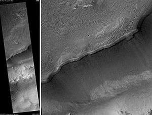 Maunder Crater, as seen by HiRISE. The overhang is part of the degraded south (toward bottom) wall of crater. The scale bar is 500 meters long. | |
| Planet | Mars |
|---|---|
| Coordinates | 50°00′S 358°30′W / 50°S 358.5°WCoordinates: 50°00′S 358°30′W / 50°S 358.5°W |
| Diameter | 107.5 km |
| Eponym | Edward W.Maunder, British astronomer (1851–1928) |
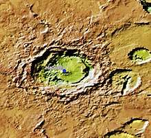
Maunder is an old, eroded crater on Mars, located in the Noachis quadrangle at 50 South and 358.5 West, and is inside Noachis Terra. It measures 107.5 kilometers in diameter and was named after British astronomer Walter Maunder in 1973.[1]
Nearby prominent and named craters include the gigantic Greeley to the north, the slightly smaller Asimov to the northeast, Russell to the southeast, Green to the southwest and Roddenberry nearly to the west.
Maunder has a thick crater rim with the westernmost portion touching the Prime Meridian.
Gullies in Maunder Crater
Martian gullies are small, incised networks of narrow channels and their associated downslope sediment deposits, found on the planet of Mars. They are named for their resemblance to terrestrial gullies. First discovered on images from Mars Global Surveyor, they occur on steep slopes, especially on the walls of craters. Usually, each gully has a dendritic alcove at its head, a fan-shaped apron at its base, and a single thread of incised channel linking the two, giving the whole gully an hourglass shape.[2] They are believed to be relatively young because they have few, if any craters. A subclass of gullies is also found cut into the faces of sand dunes which themselves considered to be quite young. On the basis of their form, aspects, positions, and location amongst and apparent interaction with features thought to be rich in water ice, many researchers believed that the processes carving the gullies involve liquid water. However, this remains a topic of active research.
As soon as gullies were discovered,[2] researchers began to image many gullies over and over, looking for possible changes. By 2006, some changes were found.[3] Later, with further analysis it was determined that the changes could have occurred by dry granular flows rather than being driven by flowing water.[4][5][6] With continued observations many more changes were found in Gasa Crater and others.[7]
With more repeated observations, more and more changes have been found; since the changes occur in the winter and spring, experts are tending to believe that gullies were formed from dry ice. Before-and-after images demonstrated the timing of this activity coincided with seasonal carbon-dioxide frost and temperatures that would not have allowed for liquid water. When dry ice frost changes to a gas, it may lubricate dry material to flow especially on steep slopes.[8][9][10] In some years frost, perhaps as thick as 1 meter,
 Topographic map showing location of Maunder Crater
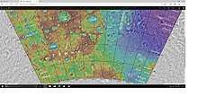 Topographical map showing location of Maunder Crater and other nearby craters
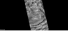 Part of Maunder crater, as seen by CTX camera on Mars Reconnaissance Orbiter. Areas of dunes and gullies are indicated.
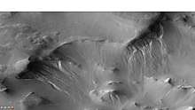 Gullies in Maunder Crater, as seen by CTX camera on Mars Reconnaissance Orbiter. Note: this is an enlargement of previous image.
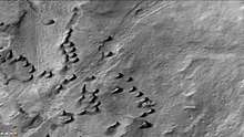 Dunes in Maunder Crater, as seen by CTX camera on Mars Reconnaissance Orbiter. Note: this is an enlargement of a previous image.
Dunes
When there are perfect conditions for producing sand dunes, steady wind in one direction and just enough sand, a barchan sand dune forms. Barchans have a gentle slope on the wind side and a much steeper slope on the lee side where horns or a notch often forms.[11] The whole dune may appear to move with the wind. Observing dunes on Mars can tell us how strong the winds are, as well as their direction. If pictures are taken at regular intervals, one may see changes in the dunes or possibly in ripples on the dune’s surface. On Mars dunes are often dark in color because they were formed from the common, volcanic rock basalt. In the dry environment, dark minerals in basalt, like olivine and pyroxene, do not break down as they do on Earth. Although rare, some dark sand is found on Hawaii which also has many volcanoes discharging basalt. Barchan is a Russian term because this type of dune was first seen in the desert regions of Turkistan.[12] Some of the wind on Mars is created when the dry ice at the poles is heated in the spring. At that time, the solid carbon dioxide (dry ice) sublimates or changes directly to a gas and rushes away at high speeds. Each Martian year 30% of the carbon dioxide in the atmosphere freezes out and covers the pole that is experiencing winter, so there is a great potential for strong winds.[13]
See also
References
- ↑ "Maunder (Martian crater)". Gazetteer of Planetary Nomenclature. USGS Astrogeology Research Program.
- 1 2 Malin, M., Edgett, K. 2000. Evidence for recent groundwater seepage and surface runoff on Mars. Science 288, 2330–2335.
- ↑ Malin, M., K. Edgett, L. Posiolova, S. McColley, E. Dobrea. 2006. Present-day impact cratering rate and contemporary gully activity on Mars. Science 314, 1573_1577.
- ↑ Kolb, et al. 2010. Investigating gully flow emplacement mechanisms using apex slopes. Icarus 2008, 132-142.
- ↑ McEwen, A. et al. 2007. A closer look at water-related geological activity on Mars. Science 317, 1706-1708.
- ↑ Pelletier, J., et al. 2008. Recent bright gully deposits on Mars wet or dry flow? Geology 36, 211-214.
- ↑ NASA/Jet Propulsion Laboratory. "NASA orbiter finds new gully channel on Mars." ScienceDaily. ScienceDaily, 22 March 2014. www.sciencedaily.com/releases/2014/03/140322094409.htm
- ↑ http://www.jpl.nasa.gov/news/news.php?release=2014-226
- ↑ http://hirise.lpl.arizona.edu/ESP_032078_1420
- ↑ http://www.space.com/26534-mars-gullies-dry-ice.html
- ↑ Pye, Kenneth; Haim Tsoar (2008). Aeolian Sand and Sand Dunes. Springer. p. 138. ISBN 9783540859109.
- ↑ http://www.britannica.com/EBchecked/topic/53068/barchan
- ↑ Mellon, J. T.; Feldman, W. C.; Prettyman, T. H. (2003). "The presence and stability of ground ice in the southern hemisphere of Mars". Icarus. 169 (2): 324–340. Bibcode:2004Icar..169..324M. doi:10.1016/j.icarus.2003.10.022.