Newton (Martian crater)
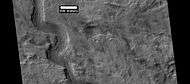
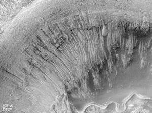 Gullies inside a small crater within Newton Crater | |
| Planet | Mars |
|---|---|
| Coordinates | 40°48′S 201°54′E / 40.8°S 201.9°ECoordinates: 40°48′S 201°54′E / 40.8°S 201.9°E |
| Diameter | 298 km |
| Eponym | Sir Isaac Newton |
Newton is a large crater on Mars, with a diameter close to 300 km.[1] It is located south of the planet's equator in the heavily cratered highlands of Terra Sirenum in the Phaethontis quadrangle. The crater was named in 1973 by the International Astronomical Union (IAU) Working Group for Planetary System Nomenclature (WGPSN) in honor of Sir Isaac Newton.

Description
The impact that formed Newton likely occurred more than 3 billion years ago. The crater contains smaller craters within its basin and is particularly notable for gully formations that are presumed to be indicative of past liquid water flows. Many small channels exist in this area; they are further evidence of liquid water. On the basis of their form, aspects, positions, and location amongst and apparent interaction with features thought to be rich in water ice, many researchers believed that the processes carving the gullies involve liquid water. However, this remains a topic of active research. As soon as gullies were discovered,[2] researchers began to image many gullies over and over, looking for possible changes. By 2006, some changes were found.[3] Later, with further analysis it was determined that the changes could have occurred by dry granular flows rather than being driven by flowing water.[4][5][6] With continued observations many more changes were found in Gasa Crater and others.[7] With more repeated observations, more and more changes have been found; since the changes occur in the winter and spring, experts are tending to believe that gullies were formed from dry ice. Before-and-after images demonstrated the timing of this activity coincided with seasonal carbon-dioxide frost and temperatures that would not have allowed for liquid water. When dry ice frost changes to a gas, it may lubricate dry material to flow especially on steep slopes.[8][9][10] In some years frost, perhaps as thick as 1 meter.
In 2011 it was announced that images captured by NASA's Mars Reconnaissance Orbiter have suggested the presence of possible flowing water during the warmest months on Mars, as shown in images taken of Newton Crater and Horowitz Crater among others.
Imagery history
The crater now called Newton were taken by Mariner 4 in 1964, the northwesternmost portion and some of its surrounding craters were taken being its 12th close up photo of Mars and the southeast portion being its 13th close up photo. The remainder was taken by Mariner 9 in 1971.
Smaller named craters inside Newton
Two smaller named craters are located inside Newton, Palikir is located south of the crater center, more than halfway to the southern rim and the smaller Avire is located west of the crater center west of Newton's central peak and is nearly halfway between that location and the western rim.
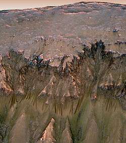
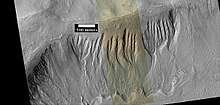
The crater name Palikir (41°34′S 158°52′W / 41.57°S 158.86°W) was officially named by the IAU in September 2011 and named it after a place in the Federated States of Micronesia,[11] and the crater name Avire (40°49′S 159°46′W / 40.82°S 159.76°W) was officially named by the IAU in April 2008 and named it after a town in Vanuatu.[12] The diameter for Palikir is 15.57 km[11] and for Avire is 6.85 km.[12] The gullies in Palikir Crater have been thought to show signs that they were carved by running water. This is in contrast to another idea that gullies were made by solid carbon dioxide (dry ice).[13] [14]
Channels
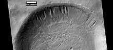
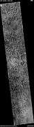
There is enormous evidence that water once flowed in river valleys on Mars.[15][16] Images of curved channels have been seen in images from Mars spacecraft dating back to the early seventies with the Mariner 9 orbiter.[17][18][19][20] Indeed, a study published in June 2017, calculated that the volume of water needed to carve all the channels on Mars was even larger than the proposed ocean that the planet may have had. Water was probably recycled many times from the ocean to rainfall around Mars.[21][22] The pictures below show a channels in Newton Crater.
 Channel on floor of Newton Crater, as seen by HiRISE under HiWish program
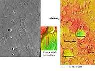 Channels on the floor of Newton Crater, as seen by THEMIS. Click on image to see relationship of Newton to other nearby craters
Dunes
Dunes are also dominant in the middle of the large crater.
 Dunes in Newton Crater, as seen by HiRISE under HiWish program
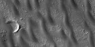 Close view of dunes in Newton Crater, as seen by HiRISE under HiWish program
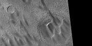 Close view of dunes in Newton Crater, as seen by HiRISE under HiWish program
- Close view of dunes in Newton Crater showing ripples on surface, as seen by HiRISE under HiWish program
See also
References
- ↑ http://www.google.com/mars/
- ↑ Malin, M., Edgett, K. 2000. Evidence for recent groundwater seepage and surface runoff on Mars. Science 288, 2330–2335.
- ↑ Malin, M., K. Edgett, L. Posiolova, S. McColley, E. Dobrea. 2006. Present-day impact cratering rate and contemporary gully activity on Mars. Science 314, 1573_1577.
- ↑ Kolb, et al. 2010. Investigating gully flow emplacement mechanisms using apex slopes. Icarus 2008, 132-142.
- ↑ McEwen, A. et al. 2007. A closer look at water-related geological activity on Mars. Science 317, 1706-1708.
- ↑ Pelletier, J., et al. 2008. Recent bright gully deposits on Mars wet or dry flow? Geology 36, 211-214.
- ↑ NASA/Jet Propulsion Laboratory. "NASA orbiter finds new gully channel on Mars." ScienceDaily. ScienceDaily, 22 March 2014. www.sciencedaily.com/releases/2014/03/140322094409.htm
- ↑ http://www.jpl.nasa.gov/news/news.php?release=2014-226
- ↑ http://hirise.lpl.arizona.edu/ESP_032078_1420
- ↑ http://www.space.com/26534-mars-gullies-dry-ice.html
- 1 2 "Gazetteer of Planetary Nomenclature | Palikir on Mars". usgs.gov. International Astronomical Union. Retrieved 19 August 2017.
- 1 2 "Gazetteer of Planetary Nomenclature | Avire on Mars". usgs.gov. International Astronomical Union. Retrieved 19 August 2017.
- ↑ Luu, K., et al. 2018. GULLY FORMATION ON THE NORTHWESTERN SLOPE OF PALIKIR CRATER, MARS 49th Lunar and Planetary Science Conference 2018 (LPI Contrib. No. 2083). 2650.pdf
- ↑ Hamid, S., V. Gulick. 2018. GEOMORPHOLOGICAL ANALYSIS OF GULLIES ALONG WESTERN SLOPES OF PALIKIR CRATER. 49th Lunar and Planetary Science Conference 2018 (LPI Contrib. No. 2083). 2644.pdf
- ↑ Baker, V., et al. 2015. Fluvial geomorphology on Earth-like planetary surfaces: a review. Geomorphology. 245, 149–182.
- ↑ Carr, M. 1996. in Water on Mars. Oxford Univ. Press.
- ↑ Baker, V. 1982. The Channels of Mars. Univ. of Tex. Press, Austin, TX
- ↑ Baker, V., R. Strom, R., V. Gulick, J. Kargel, G. Komatsu, V. Kale. 1991. Ancient oceans, ice sheets and the hydrological cycle on Mars. Nature 352, 589–594.
- ↑ Carr, M. 1979. Formation of Martian flood features by release of water from confined aquifers. J. Geophys. Res. 84, 2995–300.
- ↑ Komar, P. 1979. Comparisons of the hydraulics of water flows in Martian outflow channels with flows of similar scale on Earth. Icarus 37, 156–181.
- ↑ http://spaceref.com/mars/how-much-water-was-needed-to-carve-valleys-on-mars.html
- ↑ Luo, W., et al. 2017. New Martian valley network volume estimate consistent with ancient ocean and warm and wet climate. Nature Communications 8. Article number: 15766 (2017). doi:10.1038/ncomms15766
External links
| Wikimedia Commons has media related to Newton (Martian crater). |