Amenthes quadrangle
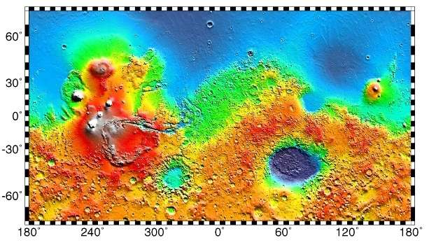
 Map of Amenthes quadrangle from Mars Orbiter Laser Altimeter (MOLA) data. The highest elevations are red and the lowest are blue. | |
| Coordinates | 15°00′N 247°30′W / 15°N 247.5°WCoordinates: 15°00′N 247°30′W / 15°N 247.5°W |
|---|---|
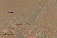
The Amenthes quadrangle is one of a series of 30 quadrangle maps of Mars used by the United States Geological Survey (USGS) Astrogeology Research Program. The Amenthes quadrangle is also referred to as MC-14 (Mars Chart-14).[1] The quadrangle covers the area from 225° to 270° west longitude and from 0° to 30° north latitude on Mars. Amenthes quadrangle contains parts of Utopia Planitia, Isidis Planitia, Terra Cimmeria, and Tyrrhena Terra.
The name Amenthes is the Egyptian word for the place where the souls of the dead go.[2]
This quadrangle contains the Isidis basin, a location where magnesium carbonate was found by MRO. This mineral indicates that water was present and that it was not acidic. There are Dark slope streaks, troughs (fossae), and river valleys (Vallis) in this quadrangle.
The Beagle 2 lander was about to land in the quadrangle, particularly in the eastern part of Isidis Planitia, in December 2003, when contact with the craft was lost. In January 2015, NASA reported the Beagle 2 had been found on the surface in Isidis Planitia (location is about 11°31′35″N 90°25′46″E / 11.5265°N 90.4295°E).[3][4] High-resolution images captured by the Mars Reconnaissance Orbiter identified the lost probe, which appears to be intact.[5][6][7] (see discovery images here)
Craters
Some craters in the Amenthes region (as well as other parts of Mars) show ejecta around them that have lobes. It is believed that the lobed shape is caused by an impact into water or ice logged ground. Calculations suggest that ice is stable beneath the Martian surface.
At the equator the stable layer of ice might lie under as much as 1 kilometer of material, but at higher latitudes the ice may be just a few centimeters below the surface. This was proven when the landing rockets on the Phoenix lander blew away surface dust to reveal an ice surface.[8][9] The larger an impact crater, the deeper its penetration, a large crater is more likely to have a lobate ejecta since it went down to the ice layer. When even small craters have lobes, the ice level is close to the surface.[10] This idea would be very important for future colonists on Mars who would like to live near a source of water.
Impact craters generally have a rim with ejecta around them, in contrast volcanic craters usually do not have a rim or ejecta deposits.[11] Sometimes craters will display layers. Since the collision that produces a crater is like a powerful explosion, rocks from deep underground are tossed unto the surface. Hence, craters can show us what lies deep under the surface. One crater in the Amenthes quadrangle is believed to be a source of nakhlite meteorites. A team of researchers found that these particular meteorites came from four different eruptions of lava because they showed different ages. The ages were measured by comparing isotopes of the element Argon. Since the ages vary from 93 to 1322 million years, the authors concluded that volcanoes grow much more slowly on Mars than the Earth. Many of the volcanoes on the Earth grow much quicker, as they form at plate boundaries. In contrast, Martian volcanoes probably form from plumes.[12]
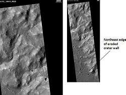 Escalante Crater wall, as seen by HiRISE Image on left is an enlargement.
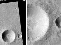 Onon Crater, as seen by HiRISE. Scale bar is 500 meters long.
 Libya Montes Region, as seen by HiRISE Image contains some sheer rock cliffs.
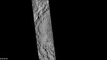 Western side of Du Martheray Crater, as seen by CTX camera (on Mars Reconnaissance Orbiter).
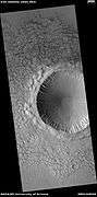 Crater and ejecta, as seen by HiRISE under HiWish program
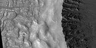 Close view of crater and ejecta, as seen by HiRISE under HiWish program
 Close view of crater, as seen by HiRISE under HiWish program
 Close view of crater ejecta, as seen by HiRISE under HiWish program
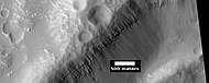 Close view of layers in crater, as seen by HiRISE under HiWish program
Hebrus Valles
Hebrus Vales has tributaries, terraces, and teardrop shaped islands. The tear drop shape of the islands indicate what direction the water used to flow. The terraces may be caused by different layers of rocks or from the water being at different levels.[13] These features are common for the rivers of the Earth.
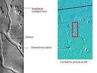 Hebrus Valles, as seen by THEMIS. Direction of flow was determined by shape of streamlined islands. Terraces may have been due to separate flood events.
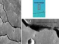 Hebrus Valles, as seen from Themis. Since discontinuous pits and troughs are present, collapse of material into a void may have caused the troughs.
Streamlined shapes
Streamlined shapes are formed from erosion by flowing water.
 Wide view of streamlined shapes, as seen by HiRISE under HiWish program
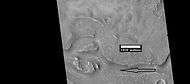 Close view of streamlined shapes, as seen by HiRISE under HiWish program Arrow indicates the direction of past flowing water.
 Close view of streamlined shapes, as seen by HiRISE under HiWish program
 Close view of streamlined shapes, as seen by HiRISE under HiWish program
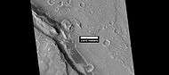 Close view of streamlined shapes, as seen by HiRISE under HiWish program
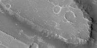 Close view of streamlined shape, as seen by HiRISE under HiWish program
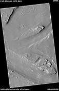 Streamlined shapes formed by flowing water, as seen by HiRISE under HiWish program
Cones
 Wide view of cones and trough, as seen by HiRISE under HiWish program
 Cone next to a trough, as seen by HiRISE under HiWish
 Cones, as seen by HiRISE under HiWish
 Line of cones, as seen by HiRISE under HiWish program
 Cones, as seen by HiRISE under HiWish program White arrows point to some of the cones.
 Close view of cones, as seen by HiRISE under HiWish program
Mesas
Mesas form when erosion has removed much of the surrounding ground. They are the remains of material that once covered a wide area.
 Layered mesa that appears to have a streamlined shape, as seen by HiRISE under HiWish program A channel has cut through a lower layer.
 Layered mesa, as seen by HiRISE under HiWish program
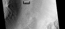
Fossae
The Amenthes quadrangle is also home to contains troughs (long narrow depressions) called fossae in the geographical language used for Mars. These troughs form when the crust is stretched until it breaks. The stretching can be due to the large weight of a nearby volcano.
 Wall of trough of Amenthes Fossae, as seen by HiRISE under HiWish program.
 Large pits, as seen by HiRISE under HiWish program
 Trough, as seen by HiRISE under HiWish program
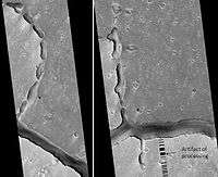 Hephaestus Fossae Two Views, as seen by HiRISE. Picture on right lies to the top (north) of other picture. Fossa (geology) often form by material moving into an underground void.
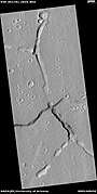 Troughs, as seen by HiRISE under HiWish program
Other landscape features in Amenthes quadrangle
 Map of Amenthes quadrangle. The northwest part includes Isidis Planitia. Escalante Crater is near the equator.
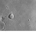 Lobate ejecta in Amenthes. Large crater has lobate ejecta, smaller craters do not show such ejecta since the ice layer was not penetrated by the smaller impacts.
 Amenthes Fossae Region, as seen by HiRISE.
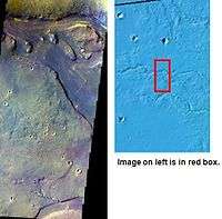 Tinjar Vallis, as seen by THEMIS. Color is enhanced to show differences.
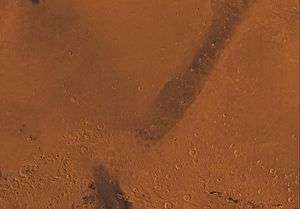
 Scamander Vallis. Dark Slope Streaks may be seen in the image. The darker the streak, the younger it is.
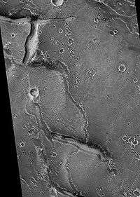 Granicus Vallis Tributary, as seen by HiRISE.
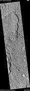 Channel along edge of crater ejecta, as seen by HiRISE under HiWish program Arrows show channel.
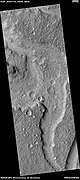 Channels, as seen by HiRISE under HiWish program
Other Mars quadrangles
Interactive Mars map
See also
References
- ↑ Davies, M.E.; Batson, R.M.; Wu, S.S.C. “Geodesy and Cartography” in Kieffer, H.H.; Jakosky, B.M.; Snyder, C.W.; Matthews, M.S., Eds. Mars. University of Arizona Press: Tucson, 1992.
- ↑ Blunck, J. 1982. Mars and its Satellites. Exposition Press. Smithtown, N.Y.
- ↑ Ellison, Doug (16 January 2015). "re Beagle 2 location on Mars => "Using HiView on image ESP_039308_1915_COLOR.JP2 I get 90.4295E 11.5265N"". Twitter & JPL. Retrieved 19 January 2015.
- ↑ Grecicius, Tony; Dunbar, Brian (16 January 2015). "Components of Beagle 2 Flight System on Mars". NASA. Retrieved 18 January 2015.
- ↑ Webster, Guy (16 January 2015). "'Lost' 2003 Mars Lander Found by Mars Reconnaissance Orbiter". NASA. Retrieved 16 January 2015.
- ↑ Associated Press (16 January 2015). "Mars Orbiter Spots Beagle 2, European Lander Missing Since 2003". The New York Times. Retrieved 17 January 2015.
- ↑ Amos, Jonathan (16 January 2015). "Lost Beagle2 probe found 'intact' on Mars". BBC. Retrieved 16 January 2015.
- ↑ http://www.nasa.gov/mission_pages/phoenix/news/phoenix-20080531.html
- ↑ http://www.nasa.gov/centers/ames/news/releases/2008/08_108AR_prt.html
- ↑ http://sci.esa.int/science-e/www/object/index.cfm?fobjectid=31026
- ↑ Hugh H. Kieffer (1992). Mars. University of Arizona Press. ISBN 978-0-8165-1257-7. Retrieved 7 March 2011.
- ↑ Cohen, B., et al. 2017. Taking the pulse of Mars via dating of a plume-fed volcano. Nature Communications. 8, 640.
- ↑ http://themis.asu.edu/zoom-20020603a
- 1 2 Morton, Oliver (2002). Mapping Mars: Science, Imagination, and the Birth of a World. New York: Picador USA. p. 98. ISBN 0-312-24551-3.
- ↑ "Online Atlas of Mars". Ralphaeschliman.com. Retrieved December 16, 2012.
- ↑ "PIA03467: The MGS MOC Wide Angle Map of Mars". Photojournal. NASA / Jet Propulsion Laboratory. February 16, 2002. Retrieved December 16, 2012.
- ↑ "Online Atlas of Mars". Ralphaeschliman.com. Retrieved December 16, 2012.
- ↑ "PIA03467: The MGS MOC Wide Angle Map of Mars". Photojournal. NASA / Jet Propulsion Laboratory. February 16, 2002. Retrieved December 16, 2012.
External links
| Wikimedia Commons has media related to Amenthes quadrangle. |
| ||||||||||||||||||||||||||||||||||||||||||||||||||||||||||||||||||||||||||||||||||||||||||||||||||||||||||||||||||||||||||||||||||||||||||||||||
| Geography | |||||||||
|---|---|---|---|---|---|---|---|---|---|
| Astronomy |
| ||||||||
| Exploration |
| ||||||||
| Related | |||||||||
| |||||||||