Athabasca River
| Athabasca River | |
.jpg) Athabasca River in Jasper National Park | |
| Country | Canada |
|---|---|
| Province | Alberta |
| Source | Columbia Icefield |
| - location | Jasper National Park |
| - elevation | 1,520 m (4,987 ft) (foot of glacier) |
| - coordinates | 52°10′4″N 117°25′50″W / 52.16778°N 117.43056°W |
| Mouth | Lake Athabasca |
| - elevation | 205 m (673 ft) |
| - coordinates | 58°37′35″N 110°50′5″W / 58.62639°N 110.83472°WCoordinates: 58°37′35″N 110°50′5″W / 58.62639°N 110.83472°W |
| Length | 1,231 km (765 mi) [1] |
| Basin | 95,300 km2 (36,796 sq mi) [1] |
| Discharge | for Athabasca Delta |
| - average | 783 m3/s (27,650 cu ft/s) [2] |
| - max | 4,790 m3/s (169,160 cu ft/s) |
| - min | 75.0 m3/s (2,650 cu ft/s) |
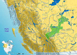 Athabasca River watershed in western Canada | |
| [3][4] | |
The Athabasca River (French: rivière Athabasca) originates from the Columbia Glacier of the Columbia Icefield in Jasper National Park in Alberta, Canada. The impressive and scenic Athabasca Falls is located upstream about 30 km (19 mi) from the Jasper townsite.
Origin of name
The name Athabasca comes from the Woods Cree word aðapaskāw, which means "[where] there are plants one after another",[5] likely a reference to the spotty vegetation along the river.
History
Sekani, Shuswap, Kootenay, Salish, Stoney and Cree tribes hunted and fished along the river prior to the European colonization. From about 1778, the Athabasca River, the Clearwater River, which enters the Athabasca River from the east at Fort McMurray, and the Methye Portage were part of the main fur trade route from the Mackenzie River to the Great Lakes. See Canadian Canoe Routes (early).
David Thompson and Thomas the Iroquois travelled through Athabasca Pass in 1811. In 1862, the Athabasca Springs area was crossed during the Cariboo Goldrush by the Overlander Party.
The northern segment of the Athabasca River became part of a major shipping network in 1921 when the Alberta and Great Waterways Railway reached Waterways near Fort McMurray, making it the northernmost point on the North American railroad grid at that time. Cargo for destinations farther north was shipped to Waterways and transferred to barges, after which fleets of tugboats took them up the river to destinations in the Athabasca and Mackenzie River watersheds. Barge traffic declined after 1964 when Hay River, on Great Slave Lake in the Northwest Territories, became the northern terminus of the rail grid.[6][7][8]
Heritage
This river was designated a Canadian Heritage River for its importance to the fur trade and the construction of railways and roads opening up the Canadian West, as well as for its natural heritage.[9]
Course
The Athabasca River originates in Jasper National Park, in an unnamed lake at the toe of the Athabasca Glacier within the Columbia Icefield, between Mount Columbia, Snow Dome, and the Winston Churchill Range, at an elevation of approximately 1,600 metres (5,200 ft).
The river flows along icefields and through gorges, offering wildlife habitat on its shores and adjacent marshes. Throughout its course, it flows through or adjacent to numerous national and provincial parks, including Jasper National Park, Fort Assiniboine Sandhills Wildland Provincial Park, Hubert Lake Wildland Provincial Park, La Biche River Wildland Provincial Park, Grand Rapids Wildland Provincial Park, Richardson River Dunes Wildland Provincial Park, and Wood Buffalo National Park. Its course is marked by rapids, impeding navigation southwest of Fort McMurray.[10]
The Athabasca River travels 1,231 km (765 mi) before draining into the Peace-Athabasca Delta near Lake Athabasca south of Fort Chipewyan. From there, its waters flow north as Rivière des Rochers, then joining the Peace River to form the Slave River that empties into Great Slave Lake and discharges through the Mackenzie River system into the Arctic Ocean. The cumulative drainage area is 95,300 km2 (36,800 sq mi).[11]
Numerous communities are located on the banks of the Athabasca River, including Jasper, Brule, Entrance, Hinton, Whitecourt, Fort Assiniboine, Smith, Athabasca, Fort McMurray, and Fort McKay.
Tributaries
|
|
|
Effects of coal and oil extraction
An independent study has concluded that the Athabasca River contains elevated levels of pollution downstream of the Athabasca oil sands. Testing has shown this portion of the river contains mercury, lead and 11 other toxic elements.[12]
Coal mine spill
On October 31, 2013, one of Obed Mountain coal mine's pits failed, and from between 600 million to a billion liters of slurry poured into the Plante and Apetowun Creeks.[13] The plume of waste products then joined the Athabasca River, travelling downstream for a month before settling in Lake Athabasca near Fort Chipewyan, over 500 km (310 mi) away.[13]
Oil spills
Owing to its proximity to the Athabasca Oil Sands, the river has seen significant amounts of energy infrastructure constructed along its course. On June 6, 1970, a pipeline operated by Great Canadian Oil Sands, the precursor to Suncor and the earliest commercial extraction operation, ruptured near the banks of the river. The total spill volume was estimated by Great Canadian Oil Sands at approximately 1,190 barrels of oil.[14][15]
Legacy
The Canadian Heraldic Authority named the position of Athabaska Herald after the river.
Gallery
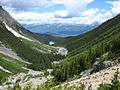 Athabasca River Valley seen from the Geraldine Lakes
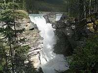 Flowing through the Athabasca Falls
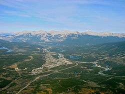 Passing by Jasper
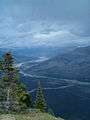 Athabasca River valley from the Pallisades fire lookout
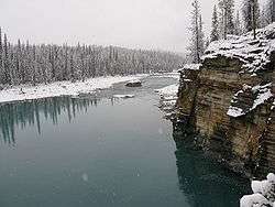
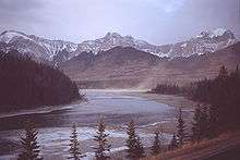 Athabasca River at the mouth of Brûlé Lake
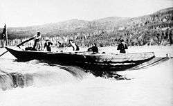
.jpg) Dr. Karl Clark and guide Romeo Eymundson on the bank of the Athabasca River.
Dr. Karl Clark and guide Romeo Eymundson on the bank of the Athabasca River.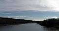 Upstream from Whitecourt
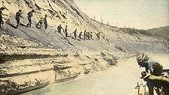 Bituminous sand banks north of Fort McMurray
See also
References
- 1 2 Atlas of Canada. "Canadian Rivers". Archived from the original on 2 February 2007. Retrieved 2007-01-16.
- ↑ Benke and Cushing, p. 845
- ↑ "Natural Resources Canada-Canadian Geographical Names (Athabasca River)". Retrieved 2014-08-29.
- ↑ "Atlas of Canada Toporama". Retrieved 2014-08-29.
- ↑ Bright, William (2004). Native American Place Names of the United States. Norman: University of Oklahoma Press, pg. 52
- ↑ "Atlas of Alberta Railways: The Alberta and Great Waterways Railway". University of Alberta. Retrieved 21 October 2017.
- ↑ "Fort McMurray tourism". Archived from the original on 2012-11-29.
- ↑
"Radium King en route: Eldorado Subsidiary's Ship Leave for West by Train". Montreal Gazette. 1937-04-15. p. 20. Retrieved 2012-05-31.
Both ships were built for the Northern Transportation Company, a subsidiary of Eldorado Gold Mines, Limited, and will ply the Mackenzie and Athabaska rivers, 1,600 miles north of Edmonton.
- ↑ Canadian Heritage River System. "Athabasca River". Archived from the original on 8 October 2006. Retrieved 2006-11-12.
- ↑ Encyclopædia Britannica (2006). "Athabasca River". Archived from the original on 31 August 2006. Retrieved 2006-09-12.
- ↑ Environment Alberta. "River Basins in Alberta". Archived from the original on 16 January 2007. Retrieved 2007-01-16.
- ↑ "Elevated levels of toxins found in Athabasca River". The Globe and Mail. August 23, 2012.
- 1 2 Wohlberg, Meagan (October 21, 2015). "Two Years Later, Charges Laid in Massive Alberta Coal Mine Spill". Vice News. Retrieved 17 February 2016.
- ↑ Province of Alberta, Alberta Government Committee Report on Great Canadian Oil Sands Oil Spill to Athabasca River June 6, 1970, Edmonton: Alberta Government, 1970. Page 3.
- ↑ "Lake Athabasca oil slick broken by wind". The Leader-Post. June 17, 1970. Retrieved July 18, 2014.
External links
- http://www.environment.alberta.ca/apps/OSEM/ Athabasca River Conditions and Use, Government of Alberta
- http://www.ramp-alberta.org/river.aspx Alberta Environmental Monitoring, Evaluation and Reporting Agency, RAMP (Regional Aquatics Monitoring Program), Athabasca River Basin
- http://www.chrs.ca/Rivers/Athabasca/Athabasca-F_e.php Canadian Heritage Rivers System (CHRS), Athabasca River
- http://arbri.athabascau.ca/About-the-Athabasca-River-basin/Index.php About the Athabasca River Basin, Athabasca River Basin Research Institute
- Kelly, EN; Schindler, DW; Hodson, PV; Short, JW; Radmanovich, R; Nielsen, CC (September 2010). "Oil sands development contributes elements toxic at low concentrations to the Athabasca River and its tributaries". Proc. Natl. Acad. Sci. U.S.A. 107: 16178–83. doi:10.1073/pnas.1008754107. PMC 2941314. PMID 20805486.
| Wikimedia Commons has media related to Athabasca River. |

| Rivers |
|
|---|---|
| Nominated | |
| |