Candor Chasma
 | |
| Coordinates | 6°36′S 70°54′W / 6.6°S 70.9°WCoordinates: 6°36′S 70°54′W / 6.6°S 70.9°W |
|---|---|
| Length | 773.238 |
Candor Chasma is one of the largest canyons in the Valles Marineris canyon system on Mars. The feature is geographically divided into two halves: East and West Candor Chasmas, respectively. It is unclear how the canyon originally formed; one theory is that it was expanded and deepened by tectonic processes similar to a graben, while another suggests that it was formed by subsurface water erosion similar to a karst.[1] MRO discovered sulfates, hydrated sulfates, and iron oxides in Candor Chasma.[2]
Features
Inside the chasma (canyon) are lesser features including mensae (mesas or tablelands) such as Ceti Mensa and Candor Mensa in the west, it has the southern and the middle portions of Baetis Mensa and in the east are Chrysas Mensa, Nia Mensa and Juventae. Chaotic terrains include Candor Chaos to the south and Nia Chaos to the east. Labes include Candor and Ceti in the west. Other features inside the chasma (canyon) that are named Candor include Candor Colles in the southwest and Candor Sulci and Candor Labes to the west.
Other nearby features

North is the smaller Ophir Chasma and south is Melas Chasma.
Candor Chasma connects with Tithoniae Catenae to the west which connects with the larger Tithonium Chasma. Nearby Candor Chasma are Ceti Chasma to the north-northeast and east is Ophir Catenae. Further east are Hydrae Chasma, Cavus and Chaos. Northwest of the canyon is the crater Perrotin and east is the smaller Pital.
Gallery
One of the pictures below shows branched channels. Many places on Mars show channels of different sizes. Many of these channels probably carried water, at least for a time. The climate of Mars may have been such in the past that water ran on its surface. It has been known for some time that Mars undergoes many large changes in its tilt or obliquity because its two small moons lack the gravity to stabilize it, as our moon stabilizes Earth; at times the tilt of Mars has even been greater than 80 degrees[3][4]
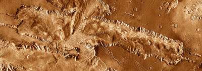
 Tectonic fractures in Candor Chasma as seen by HiRISE
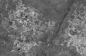 Channels in Candor plateau, as seen by HiRISE. Location is Coprates quadrangle. Click on image to see many small, branched channels which are strong evidence for sustained precipitation.
See also
References
- ↑ ESA - Mars Express - Walls of Candor Chasma
- ↑ Murchie, S. et al. 2009. A synthesis of Martian aqueous mineralogy after 1 Mars year of observations from the Mars Reconnaissance Orbiter. Journal of Geophysical Research: 114.
- ↑ name= Touma J. and J. Wisdom. 1993. The Chaotic Obliquity of Mars. Science 259, 1294-1297.
- ↑ Laskar, J., A. Correia, M. Gastineau, F. Joutel, B. Levrard, and P. Robutel. 2004. Long term evolution and chaotic diffusion of the insolation quantities of Mars. Icarus 170, 343-364.
External links
- HiRISE observation of tectonic fractures
- Virtual flyover of Candor Chasma at an altitude of 100 meters by Adrian Lark and Mars3D.com; see album for more
- High resolution flyover video by Seán Doran of layered terrain in southwest Candor Chasma, and more videos of Ceti Mensa, based on NASA digital terrain models; see album for more
- Flyover video of Ceti Mensa and west Candor Chasma by Carter Emmart; see album for more
- NASA Astronomy Picture of the Day: In Chandor Chasmata on Mars (31 May 2001)
- NASA Astronomy Picture of the Day: Candor and Ophir Chasmata (13 February 2003)
- NASA Astronomy Picture of the Day: Melas, Candor and Ophir: Valleys of Mariner (18 February 2005)