Lyot (Martian crater)
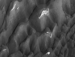 Lyot Crater Dunes, as seen by HiRISE. Click on image to see light toned deposits and dust devil tracks. | |
| Planet | Mars |
|---|---|
| Region | Ismenius Lacus quadrangle |
| Coordinates | 50°48′N 330°42′W / 50.8°N 330.7°WCoordinates: 50°48′N 330°42′W / 50.8°N 330.7°W |
| Diameter | 236 km |
| Eponym | Bernard Lyot, French astronomer (1897–1952) |
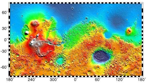
Lyot is a large crater in the Vastitas Borealis region of Mars, located at 50.8° north latitude and 330.7° west longitude within the Ismenius Lacus quadrangle. It is 236 km in diameter and was named after Bernard Lyot, a French astronomer (1897–1952).[1] The name was approved in 1973 by the International Astronomical Union (IAU) Working Group for Planetary System Nomenclature (WGPSN).[2]
Lyot stands out on the flat plains of Vastitas Borealis, which is generally flat and smooth with few large craters.[3] Lyot is the deepest point in Mars's northern hemisphere.[4] South are the Protonilus Mensae and further southeast are Protonilus Mensae. Also west is the smaller Micoud and east-southeast is Moreux. Lyot also features a central peak in the middle.
Research published in June 2009 describes evidence for liquid water in Lyot in the past.[5]
Many channels have been found near Lyot Crater. Research, published in 2017, concluded that the channels were made from water released when the hot ejecta landed on a layer of ice that was 20 to 300 meters thick. Calculations suggest that the ejecta would have had a temperature of at least 250 degrees Fahrenheit. The valleys seem to start from beneath the ejecta near the outer edge of the ejecta. One evidence for this idea is that there are few secondary craters nearby. Few secondary craters were formed because most landed on ice and did not affect the ground below. The ice accumulated in the area when the climate was different. The tilt or obliquity of the axis changes frequently. During periods of greater tilt, ice from the poles is redistributed to the mid-latitudes. The existence of these channels is unusual because although Mars used to have water in rivers, lakes, and an ocean, these features have been dated to the Noachian and Hesperian periods—4 to 3 billion years ago.[6][7][8]
Former rivers
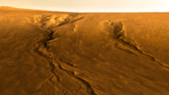
Images from Mars Reconnaissance Orbiter show valleys carved by rivers on the floor of Lyot Crater. Scientists are excited because the rivers seem to have formed more recently than others on Mars; water could have flowed in them only 1.25 million years ago. The source of the water is believed to have been ice from nearby glaciers. The river valleys are over 250 meters wide and tens of kilometers long.[9]
 Wide view of channels in Lyot Crater, as seen by HiRISE unser HiWish program
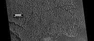 Close view of channels in Lyot Crater, as seen by HiRISE under HiWish program
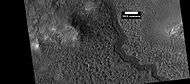 Close view of channels in Lyot Crater, as seen by HiRISE under HiWish program
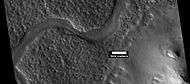 Curved channel in Lyot Crater, as seen by HiRISE under HiWish program
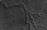 Channels in Lyot as seen by HiRISE
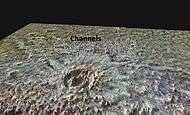 Lyot crater with elevations exaggerated showing distribution of channels caused by hot ejecta melting ice.
Dust devil tracks
Many areas on Mars, including Lyot, experience the passage of giant dust devils. A thin coating of fine bright dust covers most of the Martian surface. When a dust devil goes by it blows away the coating and exposes the underlying dark surface. These dust devils have been seen from the ground and high overhead from orbit.
Gallery
 Gullies on Central Uplift of Lyot Crater, image reprocessed from HiRISE data.
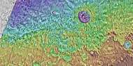 MOLA map of Lyot and other nearby craters. Colors indicate elevations.
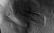 Lyot Crater Gullies, as seen by HiRISE.
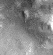 Lyot Crater Channel, as seen by CTX. Water-carved channels have been spotted in Lyot Crater; the curved line may be one. Click on image for a better view.
Interactive Mars map
See also
References
- ↑ http://www.google.com/mars/
- ↑ http://plantarynames.wr.usgs.gov Archived 2013-08-01 at the Wayback Machine.
- ↑ U.S. department of the Interior U.S. Geological Survey, Topographic Map of the Eastern Region of Mars M 15M 0/270 2AT, 1991
- ↑ http://space.com/scienceastronomy/090514--mars-rivers.html
- ↑ Dickson, J. L., Fassett, C. I., Head, J. W., Amazonian-aged fluvial valley systems in a climatic microenvironment on Mars: Melting of ice deposits on the interior of Lyot Crater, GRL, vol. 36, 2009 http://adsabs.harvard.edu/abs/2009GeoRL..3608201D
- ↑ Weiss, David K. "Extensive Amazonian-aged fluvial channels on Mars: Evaluating the role of Lyot crater in their formation". Geophysical Research Letters. 44: 5336–5344. Bibcode:2017GeoRL..44.5336W. doi:10.1002/2017GL073821.
- ↑ Weiss, D.; et al. (2017). "Extensive Amazonian-aged fluvial channels on Mars: Evaluating the role of Lyot crater in their formation". Geophysical Research Letters. 44: 5336–5344. Bibcode:2017GeoRL..44.5336W. doi:10.1002/2017GL073821.
- ↑ http://spaceref.com/mars/hot-rocks-led-to-relatively-recent-water-carved-valleys-on-mars.html
- ↑ http://www.space.com/scienceastronomy/090514-mars-rivers.html
External links
| Wikimedia Commons has media related to Lyot (Martian crater). |