Airy-0
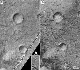 Three images of Airy-0 taken by, from A to C, Mariner 9, Viking 1 and Mars Global Surveyor. Airy-0 is the larger crater towards the top center in each frame. | |
| Planet | Mars |
|---|---|
| Region | Inside Airy Crater |
| Coordinates | 5°06′S 0°00′E / 5.1°S 0°ECoordinates: 5°06′S 0°00′E / 5.1°S 0°E |
| Diameter | 0.5 kilometres (0.31 mi) |
| Eponym | Sir George Biddell Airy |
Airy-0 is a crater on Mars whose location defined the position of the prime meridian of that planet. It is about 0.5 kilometres (0.31 mi) across and lies within the larger crater Airy in the region Sinus Meridiani. The IAU Working Group on Cartographic Coordinates and Rotational Elements has now recommended setting the longitude of the Viking 1 lander (47°.95137 west) as the standard. This definition maintains the position of the center of Airy-0 at 0° longitude, within the tolerance of current cartographic uncertainties.[1]
Merton Davies tied this crater into an extensive geodetic control network of the planet Mars based on Mariner 9 and earlier photographs.[2] [3] The Mariner 9 Geodesy/Cartography Group proposed that the prime meridian of Mars be defined by the center of Airy-0, which was selected by Harold Masursky, Gerard de Vaucouleurs, and Merton Davies at a Group meeting on 14 August 1972.[4]
It was named in honor of the British Astronomer Royal Sir George Biddell Airy (1801-1892), who in 1850 built the transit circle telescope at Greenwich. The location of that telescope was subsequently chosen to define the location of Earth's prime meridian.

References
- ↑ Archinal, B.A.; Acton, C.H.; A’Hearn, M.F.; Conrad, A.; et al. (2018), "Report of the IAU Working Group on Cartographic Coordinates and Rotational Elements: 2015", Celestial Mechanics and Dynamical Astronomy, 130 (22), doi:10.1007/s10569-017-9805-5,
The origin of the longitude system for Mars is now defined by assigning a longitude of 47°.95137 west to the Viking 1 lander…. The longitude uncertainty within which landed resources can be determined by radiometric tracking is now … significantly smaller than the uncertainty of determining the center of the ∼500 m diameter Airy-0, the time has come to transition the orientation of the longitude system from being based on Airy-0 to the much smaller Viking 1 lander, for which there are extensive radiometric tracking data.
- ↑ "The Martian Prime Meridian -- Longitude "Zero"" (MGS MOC Release No. MOC2-273). Malin Space Science Systems. 31 January 2001. Retrieved 31 March 2018.
- ↑ Morton, Oliver (2002). Mapping Mars: Science, Imagination, and the Birth of a World. New York: Picador USA. pp. 22–23. ISBN 0-312-24551-3.
- ↑ de Vaucouleurs, Gerard; Davies, Merton E.; Sturms, Francis M., Jr. (1973), "Mariner 9 Areographic Coordinate System", Journal of Geophysical Research, 78 (20): 4395–4404, doi:10.1029/JB078i020p04395