Isidis Planitia
 Topography of Isidis Planitia | |
| Planet | Mars |
|---|---|
| Region | North of Hellas Planitia, east of Syrtis Major Planum |
| Coordinates | 12°54′N 87°00′E / 12.9°N 87.0°ECoordinates: 12°54′N 87°00′E / 12.9°N 87.0°E |
| Diameter | 1,500 km (930 mi) |
| Eponym | Isis is the Egyptian goddess of heaven and fertility. |
Isidis Planitia is a plain located inside a giant impact basin on Mars, centered at 12°54′N 87°00′E / 12.9°N 87.0°E; Isidis Planitia is partly in the Syrtis Major quadrangle and partly in the Amenthes quadrangle. It is the third biggest obvious impact structure on the planet after the Hellas and Argyre basins – it is about 1,500 km (930 mi) in diameter.
Isidis was likely the last major basin to be formed on Mars, having formed approximately 3.9 billion years ago during the Noachian Period.[1] Due to dust coverage, it typically appears bright in telescopic views, and was mapped as a classical albedo feature, Isidis Regio, visible by telescope in the pre-spacecraft era.
A study reported in Icarus, described the complex geologic history of parts of Isidis, especially areas near the Deuteronilus contact. This contact is the supposed edge of a vast Martian ocean. The researchers found evidence of a Late Hesperian/Early Amazonian Sea in the area. The sea would have quickly froze over. Eskers formed under the ice.[2]
Just to the west of Isidis is Syrtis Major Planum, a low-relief shield volcano that is a prominent dark albedo feature of Mars, which formed after the basin.[3]
Around the Isidis basin magnesium carbonate was found by MRO. This mineral indicates that water was present and that it was not acidic, pH conditions more favorable for the evolution of life.[4]
The name "Isidis Planitia" follows the earlier name Isidis Regio ("Isis' Region"). Isis is the Egyptian goddess of heaven and fertility.
Gallery
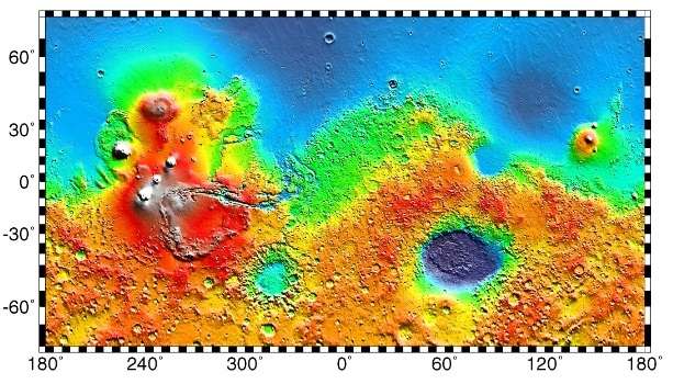
 MOLA map showing boundaries of Isidis Planitia and other regions
 MOLA colorized topographic map showing Isidis Planitia (right) and the adjacent low-relief shield volcano Syrtis Major Planum (left).
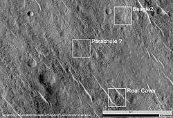
Beagle 2
The Beagle 2 lander was about to land in the eastern part of Isidis Planitia in December 2003, when contact with the craft was lost. In January 2015, NASA reported the Beagle 2 had been found on the surface in Isidis Planitia (location is about 11°31′35″N 90°25′46″E / 11.5265°N 90.4295°E).[5][6] High-resolution images captured by the Mars Reconnaissance Orbiter identified the lost probe, which appears to be intact.[7][8][9] (see discovery images here)


Interactive Mars map
See also
References
- ↑ Ritzer, J.; Hauck, S. (June 2009), "Lithospheric structure and tectonics at Isidis Planitia, Mars", Icarus, 201 (2): 528–539, Bibcode:2009Icar..201..528R, doi:10.1016/j.icarus.2009.01.025
- ↑ Erkelinga, G., D. Reissa, H. Hiesingera, M.A. Ivanovb, E. Hauberc, H. Bernhardta. Landscape formation at the Deuteronilus contact in southern Isidis Planitia, Mars: Implications for an Isidis Sea? Icarus:242, 329–35
- ↑ Hiesinger, H.; Head, J. W. (publications) (2004-01-08), "The Syrtis Major volcanic province, Mars: Synthesis from Mars Global Surveyor data" (PDF), Journal of Geophysical Research: Planets, 109 (E1): E01004, Bibcode:2004JGRE..10901004H, doi:10.1029/2003JE002143, E01004
- ↑ Murchie, S. L.; Mustard, J. F.; Ehlmann, B. L.; Milliken, R. E.; Bishop, J. L.; McKeown, N. K.; Noe Dobrea, E. Z.; Seelos, F. P.; Buczkowski, D. L.; Wiseman, S. M.; Arvidson, R. E.; Wray, J. J.; Swayze, G.; Clark, R. N.; Des Marais, D. J.; McEwen, A. S.; Bibring, J.-P. (February 2009). "A synthesis of Martian aqueous mineralogy after 1 Mars year of observations from the Mars Reconnaissance Orbiter". Journal of Geophysical Research: Planets. 114 (E2). Bibcode:2009JGRE..114.0D06M. doi:10.1029/2009JE003342. ISSN 0148-0227.
- ↑ Ellison, Doug (16 January 2015). "re Beagle 2 location on Mars => "Using HiView on image ESP_039308_1915_COLOR.JP2 I get 90.4295E 11.5265N"". Twitter & JPL. Retrieved 19 January 2015.
- ↑ Grecicius, Tony; Dunbar, Brian (16 January 2015). "Components of Beagle 2 Flight System on Mars". NASA. Retrieved 18 January 2015.
- 1 2 Webster, Guy (16 January 2015). "'Lost' 2003 Mars Lander Found by Mars Reconnaissance Orbiter". NASA. Retrieved 16 January 2015.
- ↑ Associated Press (16 January 2015). "Mars Orbiter Spots Beagle 2, European Lander Missing Since 2003". New York Times. Retrieved 17 January 2015.
- ↑ Amos, Jonathan (16 January 2015). "Lost Beagle2 probe found 'intact' on Mars". BBC. Retrieved 16 January 2015.
External links