Ulta
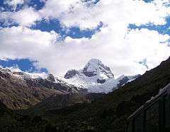
Ulta[1][2][3] is a mountain in the Cordillera Blanca in the Andes of Peru, about 5,875 metres (19,275 ft) high[1] (although Peruvian IGN map cites an elevation of 5,782 metres (18,970 ft)).[2][3] It is in the region of Ancash.
| Ulta | |
|---|---|
 Ulta | |
| Highest point | |
| Elevation | 5,875 m (19,275 ft) |
| Coordinates | 9°08′58.55″S 77°31′21.88″W |
| Geography | |
 Ulta Peru | |
| Location | Ancash, Peru |
| Parent range | Andes, Cordillera Blanca |
References
- Alpenvereinskarte 0/3a. Cordillera Blanca Nord (Peru). 1:100 000. Oesterreichischer Alpenverein. 2005. ISBN 3-928777-57-2.
- Peru 1:100 000, Carhuás (19-h). IGN (Instituto Geográfico Nacional - Perú).
- Biggar, John (2005). The Andes: A Guide for Climbers. Andes. p. 76. ISBN 9780953608720.
This article is issued from Wikipedia. The text is licensed under Creative Commons - Attribution - Sharealike. Additional terms may apply for the media files.