Lambton County
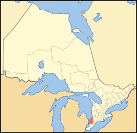
Lambton County is a county in Southwestern Ontario, Canada. It is bordered on the north by Lake Huron, which is drained by the St. Clair River, the county's western border and part of the Canada-United States border. To the south is Lake Saint Clair and Chatham-Kent, another county in Ontario. Lambton County's northeastern border follows the Ausable River and Parkhill Creek north until it reaches Lake Huron at the beach community of Grand Bend. The county seat is in the Town of Plympton-Wyoming.
Lambton County | |
|---|---|
County (upper-tier) | |
| County of Lambton | |
 Location of Lambton County | |
| Coordinates: 42°54′N 82°06′W | |
| Country | |
| Province | |
| Formed | 1849 |
| County seat | Wyoming[1] |
| Municipalities | List
|
| Area | |
| • Land | 3,002.25 km2 (1,159.18 sq mi) |
| Population (2016)[2] | |
| • Total | 123,399 |
| • Density | 43.8/km2 (113/sq mi) |
| Demonym(s) | Lambtoneer |
| Time zone | UTC-5 (EST) |
| • Summer (DST) | UTC-4 (EDT) |
| Website | www.lambtononline.ca/ |
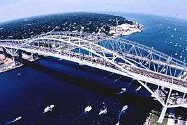
The largest city in Lambton County is Sarnia,[3] which is located at the mouth of the St. Clair River. The two Blue Water Bridges cross the river at Sarnia, connecting it to Port Huron, Michigan. The bridges are one of the busiest border crossings between the two countries. The river is also traversed by two passenger ferries further south, and a rail tunnel, also at Sarnia, runs underneath it. The CN rail tunnel accommodates double stacked rail cars. Along with Sarnia, the population centres in Lambton County are: Corunna, Petrolia, Grand Bend, Wyoming, Forest, and Watford.
Lambton County started as a part of the District of Hesse. The district of Hesse included British territories west of Long Point (practically all of western Ontario). The district was later divided and renamed using English district names (Essex, Suffolk, Kent, etc.). Lambton was part of Kent county. In 1849 districts were abolished and the County of Lambton was formed. Lambton and Kent first shared the capital city of Sandwich (since renamed as Windsor, Ontario). In 1852 the partnership was dissolved and Lambton become a full county. It is named in honour of John Lambton, 1st Earl of Durham, who visited the area in the late 1830s.[4]
Subdivisions
Lambton County consists of 11 municipalities (in order of population):
- City of Sarnia
- Township of St. Clair
- Municipality of Lambton Shores
- Town of Plympton–Wyoming
- Town of Petrolia
- Township of Warwick
- Township of Enniskillen
- Township of Brooke-Alvinston
- Village of Point Edward
- Township of Dawn-Euphemia
- Village of Oil Springs
Independent First Nation reserves
Independent of the County, but located within the Lambton census division, are three First Nations reserves:
- Chippewas of Kettle and Stony Point First Nation, in the Kettle Point area
- Aamjiwnaang First Nation, located near many of the refineries in Sarnia's Chemical Valley
- Walpole Island, near Wallaceburg
Demographics
Historic population:
- 2016: 123,399 (5-year growth rate: -1.0%)[2]
- 2011: 124,623 (5-year growth rate: 0.0%)
- 2006: 124,600 (5-year growth rate: 0.8%)
- 2001: 123,611 (5-year growth rate: -2.5%)
- 1996: 126,829
The demographics below are for the Lambton census division, which combines Lambton County and three First Nations reserves.
| Canada census – Lambton County community profile | |||
|---|---|---|---|
| 2016 | 2011 | 2006 | |
| Population: | 126,638 (0.3% from 2011) | 126,199 (-1.6% from 2006) | 128,204 (1.0% from 2001) |
| Land area: | 3,002.25 km2 (1,159.18 sq mi) | 3,002.07 km2 (1,159.11 sq mi) | 3,001.70 km2 (1,158.96 sq mi) |
| Population density: | 42.2/km2 (109/sq mi) | 42.0/km2 (109/sq mi) | 42.7/km2 (111/sq mi) |
| Median age: | 43.9 (M: 42.8, F: 44.8) | 42.8 (M: 41.8, F: 43.6) | |
| Total private dwellings: | 54,480 | 58,243 | 56,919 |
| Median household income: | |||
| Notes: Excludes census data for one or more incompletely enumerated Indian reserves – References: 2016[5] 2011[6] 2006[7] earlier[8] | |||
Economy
Total employment for Lambton County is 66,370. Of those, 9,760 (14.7%) are employed in manufacturing; 7,545 (11.4%) in retail trade; 5,080 (7.7%) in accommodation and food services; and 3,155 (4.8%) are employed in agriculture.
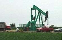
Petrochemical and refining is the largest manufacturing sector in Lambton County's economy. Established during World War II, Sarnia and the area along the St. Clair River is home to a major processing centre for oil from Alberta.
In late 2010 and early 2011 a number of companies announced plans to provide ethane from the Marcellus Shale in the USA to Lambton County industries, providing a potential new feedstock for the production of ethylene in Lambton County.
Lambton County is the site of North America's first drilled commercial oil well at Oil Springs in 1858.
Tourism is another important industry in Lambton County, especially along the lake and river. The community of Grand Bend and the Pinery Provincial Park are especially popular tourist destinations, attracting thousands of people each week throughout the summer to their long, uninterrupted beaches. The part of Lambton County along Lake Huron known as Lambton Shores depends almost entirely upon the seasonal industries of tourism and agriculture for its well-being. There are also popular conservation areas along the St. Clair River, and a conservation area named Rock Glen Falls near Arkona along the Ausauble River internationally known for its Devonian period fossils.
Lambton County has 2,346 farms with a total of 592,793 acres. The largest single use of farmland in Lambton is crop production, with 85% of total farmland reported as land in crops. Over the last 20 years soybeans, wheat, and grain corn have accounted for over 80% of total area crop production in Lambton. The fourth and fifth leading crops are sugar beets and hay. Oats, barley and mixed grains are also produced. Top animal production includes dairy, beef, hog, and poultry.[9]
Infrastructure
Highways


Emergency services
The County of Lambton Emergency Medical Services (EMS) provides land ambulance services to the residents of Lambton County. The County of Lambton EMS has stations in Brigden, Corunna, Forest, Grand Bend, Petrolia, Thedford, Watford, and two stations in Sarnia. Lambton EMS has ten ambulances and employs approximately 150 full- and part-time Primary Care Paramedics.[10]
Policing is provided by the Ontario Provincial Police (OPP), which has detachments in Grand Bend, Forest, Petrolia, Corunna, and Point Edward. The area of Kettle & Stony Point which is one of three native reservations in Lambton County, is policed by the Anishnabek Police Service (APS) but dispatched by the OPP. Walpole Island, another first nations reservation has its own police service, the Walpole Island Police Service. The remaining first nations reservation, Aamjiwnaang First Nation, which falls geographically within the City of Sarnia, is covered by the Sarnia Police Service.
Communities
- Alvinston
- Arkona
- Brigden
- Brights Grove
- Corunna
- Courtright
- Forest
- Grand Bend
- Osborne
- Petrolia
- Port Franks
- Port Lambton
- Sarnia
- Sombra
- Thedford
- Walpole Island
- Watford
- Wyoming
See also
- List of municipalities in Ontario
- List of Ontario Census Divisions
- List of townships in Ontario
References
- "Contact Us". The Corporation of the County of Lambton. Retrieved August 6, 2019.
- "Census Profile, 2016 Census - Lambton, County (Census division), Ontario and Ontario (Province)". Canada 2016 Census. Statistics Canada. Retrieved 9 July 2017.
- "City of Sarnia - Overview". Retrieved 9 July 2017.
- "The Man Who Gave Lambton Its Name". LambtonCounty.com. Retrieved 10 November 2018.
- "2016 Community Profiles". 2016 Canadian Census. Statistics Canada. February 21, 2017. Retrieved 2017-07-09.
- "2011 Community Profiles". 2011 Canadian Census. Statistics Canada. July 5, 2013. Retrieved 2012-03-28.
- "2006 Community Profiles". 2006 Canadian Census. Statistics Canada. March 30, 2011. Retrieved 2012-03-28.
- "2001 Community Profiles". 2001 Canadian Census. Statistics Canada. February 17, 2012.
- "Agriculture". Sarnia-Lambton Economic Partnership. Retrieved 10 November 2018.
- "Emergency Medical Services". Corporation of the County of Lambton. Retrieved 9 July 2017.
External links
| Wikimedia Commons has media related to Lambton County, Ontario. |
- Lambton County - The Corporation of the County of Lambton.
- Ontario Visual Heritage Project: Sarnia-Lambton
- Historic bridges in Lambton County
- Lambton County History
- Grand Bend Strip community newspaper - serving north Lambton County (Grand Bend and Port Franks).
Places adjacent to Lambton County | |
|---|---|
| Regions | |
|---|---|
| Counties | |
| Districts | |
| Regional municipalities | |
| Single-tier municipalities | |
| Separated municipalities | |
| |