59th Street–Columbus Circle station
59th Street–Columbus Circle is a New York City Subway station complex shared by the IRT Broadway–Seventh Avenue Line and the IND Eighth Avenue Line. It is the eighth-busiest station complex in the system.[5] It is located at Columbus Circle in Manhattan, where 59th Street, Broadway and Eighth Avenue intersect, and serves Central Park, the Upper West Side, Hell's Kitchen, and Midtown Manhattan. The station is served by the:
- 1, A, and D trains at all times
- C train at all times except late nights
- B train during weekdays until 11:00 p.m.
- 2 train during late nights
59 Street–Columbus Circle | |||||||||||||
|---|---|---|---|---|---|---|---|---|---|---|---|---|---|
 Station entrance north of Columbus Circle | |||||||||||||
| Station statistics | |||||||||||||
| Address | Intersection of West 59th Street, Eighth Avenue & Broadway New York, NY 10023 | ||||||||||||
| Borough | Manhattan | ||||||||||||
| Locale | Columbus Circle, Midtown Manhattan | ||||||||||||
| Coordinates | 40.767997°N 73.981934°W | ||||||||||||
| Division | A (IRT), B (IND) | ||||||||||||
| Line | IND Eighth Avenue Line IRT Broadway–Seventh Avenue Line | ||||||||||||
| Services | 1 2 A B C D | ||||||||||||
| Transit connections | |||||||||||||
| Levels | 2 | ||||||||||||
| Other information | |||||||||||||
| Opened | July 1, 1948[1] | ||||||||||||
| Station code | 614[2] | ||||||||||||
| Accessible | |||||||||||||
| Wireless service | |||||||||||||
| Traffic | |||||||||||||
| Passengers (2019) | 23,040,650[4] | ||||||||||||
| Rank | 8 out of 424[4] | ||||||||||||
| |||||||||||||
| |||||||||||||
| |||||||||||||


Station layout
| G | Street level | Exits/entrances |
| B1 | Mezzanine | Fare control, station agent, MetroCard vending machines Shops, to exits |
| Side platform | ||
| Northbound local | ← ← | |
| Northbound express | ← | |
| Southbound express | | |
| Southbound local | | |
| Side platform | ||
| B2 | IND mezzanine | Transfers between lines and platforms |
| B3 | Northbound local | ← ← ← |
| Island platform | ||
| Northbound express | ← ← | |
| Island platform, not in service, used as passageway between IRT Broadway–Seventh Avenue Line platforms | ||
| Southbound express | | |
| Island platform | ||
| Southbound local | | |
Entrances and exits

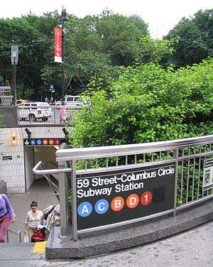
This station complex has many entrances/exits from the streets. The one at the north end of Columbus Circle leads to the Trump International Hotel and Tower. It has a double wide staircase going down to an intermediate level before another double-wide staircase goes down to fare control, where a now unused token booth and turnstile bank lead to the IND mezzanine as well as the north end of the northbound IRT platform. There is also one elevator from the back of the staircase that goes down to fare control.[6]
Two staircases from the northwest corner of Broadway and West 60th Street go down to an unstaffed fare control area, where three full height turnstiles and a short staircase provide direct access to the north end of the southbound IRT platform. Another staircase at the southern island of the aforementioned intersection go down to a bank of turnstiles leading to the center of the same platform.[6]
The Time Warner Center at the northwest corner of West 58th Street and Eighth Avenue has a set of elevators, escalators, and staircases going down to fare control, where a token booth and turnstile bank provide entrance/exit to the station. A single staircase goes down to each IND platform at their extreme south end while a passageway leads to the southbound IRT platform. The mezzanine also has a staircase going up to the northeast corner of West 58th Street and Eighth Avenue. There is a passageway leading to another staircase that goes up to the northwest corner of West 57th Street and Eighth Avenue. This staircase is built within the Hearst Tower.[6] A complex of restaurants and shops called "Turnstyle" opened in this passageway in April 2016.[7]
The south end of the northbound IRT platform has a same-level unstaffed fare control area containing full height turnstiles and two staircases going up to the south corners of West 59th Street and Broadway.[6]
In October 1992, at a public hearing, New York City Transit proposed closing street staircase S6 to the northwest corner 61st Street and Central Park West and reopening street staircase S2 at 60th Street and Central Park West, located to the east of the circular stair, in order to expand the Transit Police District Command to accommodate more officers and increase the efficiency of the operation. The circular staircase was expected to be reconstructed to provide more direct access The 61st Street exit was operated part-time, closing at nights, consisted of a high exit turnstile and was used by 2400 daily passengers. It was located in a remote unmonitored portion of the station, making safety an added consideration for its closure. Four staircases to the two platforms that led to the passageway leading to the exit were removed.[8][9]
IRT Broadway–Seventh Avenue Line platforms
59 Street–Columbus Circle | |||||||||
|---|---|---|---|---|---|---|---|---|---|
 Uptown platform | |||||||||
| Station statistics | |||||||||
| Division | A (IRT) | ||||||||
| Line | IRT Broadway–Seventh Avenue Line | ||||||||
| Services | 1 2 | ||||||||
| Structure | Underground | ||||||||
| Platforms | 2 side platforms | ||||||||
| Tracks | 4 | ||||||||
| Other information | |||||||||
| Opened | October 27, 1904[10] | ||||||||
| Station code | 315[2] | ||||||||
| Accessible | |||||||||
| Wireless service | |||||||||
| Opposite-direction transfer available | Yes | ||||||||
| Station succession | |||||||||
| Next north | 66th Street–Lincoln Center: 1 | ||||||||
| Next | 66th Street–Lincoln Center: 1 | ||||||||
| Next south | 50th Street: 1 | ||||||||
| Next | Times Square–42nd Street: 1 | ||||||||
| |||||||||
59th Street – Columbus Circle (IRT) | |||||||||
New York City Landmark No. 1096 | |||||||||
| MPS | New York City Subway System MPS | ||||||||
| NRHP reference No. | 04001015[11] | ||||||||
| NYCL No. | 1096 | ||||||||
| Significant dates | |||||||||
| Added to NRHP | September 17, 2004 | ||||||||
| Designated NYCL | November 24, 1981[12] | ||||||||
59th Street–Columbus Circle on the IRT Broadway–Seventh Avenue Line has four tracks and two side platforms.[13]
History
Operation of the first subway began on October 27, 1904, with the opening of the original 28 stations of the New York City Subway from City Hall to 145th Street on the West Side Branch including the 59th Street station.[14]:162–191[15]
Despite being a major transfer point to the IND Eighth Avenue Line, the station was constructed as a local stop prior to the IND's construction in 1932. During the 1950s, the New York City Transit Authority considered converting the station to an express stop by rerouting the local tracks to the outside of the platforms.[16] This would have coincided with 72nd Street becoming a local stop by fencing off or walling up the express side of the island platforms there. The conversion of the station to an express station was planned to serve the under construction New York Coliseum.[16]
When the station opened, there was an underpass between the downtown and uptown platforms. In 1991, it was closed and the staircase entrances covered over. Today, passengers use the IND mezzanine and platforms to transfer between directions. Both platforms have two fare controls which are on the same level, one of which connects to the mezzanine leading to the IND platforms.
Image gallery
 Name in mosaics
 Original cartouche featuring Columbus's ship the Santa Maria
 Detailed view of the ceiling
 The uptown platform in 1978
IND Eighth Avenue Line platforms
59 Street–Columbus Circle | |||||||||||||
|---|---|---|---|---|---|---|---|---|---|---|---|---|---|
 | |||||||||||||
| Station statistics | |||||||||||||
| Division | B (IND) | ||||||||||||
| Line | IND Eighth Avenue Line | ||||||||||||
| Services | A B C D | ||||||||||||
| Structure | Underground | ||||||||||||
| Platforms | 3 island platforms (2 in passenger service) cross-platform interchange | ||||||||||||
| Tracks | 4 | ||||||||||||
| Other information | |||||||||||||
| Opened | September 10, 1932[17] | ||||||||||||
| Station code | 161[2] | ||||||||||||
| Accessible | |||||||||||||
| Wireless service | |||||||||||||
| Opposite-direction transfer available | Yes | ||||||||||||
| Station succession | |||||||||||||
| Next north | 125th Street (express): A 72nd Street (local): A | ||||||||||||
| Next | 125th Street: A | ||||||||||||
| Next south | Seventh Avenue (6th): B 50th Street (8th local): A 42nd Street–Port Authority Bus Terminal (8th express): A | ||||||||||||
| Next | 50th Street (via 8th local): A 47th–50th Streets–Rockefeller Center (via 6th): B 42nd Street–Port Authority Bus Terminal (via 8th express): A | ||||||||||||
| |||||||||||||
59th Street–Columbus Circle on the IND Eighth Avenue Line, which opened on September 10, 1932, is a large express station. There are four tracks and three island platforms with the outer two in revenue service.
South of the station, trains can either continue on Eighth Avenue or diverge east to the Seventh Avenue station via the IND Sixth Avenue Line. North of the station are crossovers in both directions, and the northbound tracks cross over the southbound tracks to form a two-level configuration to 103rd Street. The next express station to the north, 125th Street, is 3.35 miles (5.391 km) away with seven local stations in between. This is the longest distance between two express stops in the system.
At the middle of each open platform, there are two staircases and one elevator that connect with the northbound platform of IRT Broadway–Seventh Avenue Line. There is also one staircase from each platform at the north end leading to the same area. A single staircase at the extreme south end connects to the southbound IRT platform. There are two newsstands, one each at the center of both platforms.
This station formerly had a 1992 artwork called Hello Columbus, made by various New York City artists and public school students. Sol LeWitt created tile work on the stairway from the IND platforms to the uptown IRT platform entitled Whirls and Twirls, installed in 2009.[8] Large white "59"s are placed over the blue stripes–similar to the "42"s at 42nd Street–Port Authority.
History


When the Eighth Avenue Line was being built, the station was originally planned to be located at 57th Street, with entrances extending up to 61st Street. This station, along with the IRT station, was designed as a major transit hub under Columbus Circle.[18] The station opened on September 10, 1932, as part of the city-operated Independent Subway System (IND)'s initial segment, the Eighth Avenue Line between Chambers Street and 207th Street.[17]
The center platform was originally built along with the other platforms, but was first used in passenger service in 1959. It served the purpose of a Spanish solution, allowing passengers to exit both sides of subway cars as the express trains would open the doors on both sides. Newer subway cars' door controls made it more difficult to open doors on both sides of the train simultaneously; thus this solution became impractical and the platform was closed on November 8, 1973. In 2007–2010, it was converted to a crossunder between the IRT side platforms. Large metal fences have been erected to keep people away from the edges.
Nearby points of interest
- Church of St. Paul the Apostle[6]
- Museum of Arts & Design[6]
- New York Institute of Technology[6]
- Professional Children's School[6]
- John Jay College of Criminal Justice[6]
- Fordham University[6]
References
- "Transfer Points Under Higher Fare". The New York Times. June 30, 1948. p. 19.
- "Station Developers' Information". Metropolitan Transportation Authority. Retrieved June 13, 2017.
- "NYC Subway Wireless – Active Stations". Transit Wireless Wifi. Retrieved November 13, 2019.
- "Facts and Figures: Annual Subway Ridership 2014–2019". Metropolitan Transportation Authority. 2020. Retrieved May 26, 2020.
- "MTA Neighborhood Maps: Midtown West" (PDF). mta.info. Metropolitan Transportation Authority. 2015. Retrieved December 11, 2015.
- Kral, Georgia (April 19, 2016). "Inside TurnStyle, the food and retail hub under Columbus Circle". am New York. Retrieved November 28, 2017.
- Review of the A and C Lines (PDF) (Report). Metropolitan Transportation Authority. December 11, 2015. Archived from the original (PDF) on February 3, 2020. Retrieved January 19, 2016.
-
- NYC Transit Committee Agenda September 1994. New York City Transit. September 16, 1994. pp. D.70.
- NYC Transit Committee Agenda September 1994. New York City Transit. September 16, 1994. pp. D.71.
- NYC Transit Committee Agenda September 1994. New York City Transit. September 16, 1994. pp. D.72.
- NYC Transit Committee Agenda September 1994. New York City Transit. September 16, 1994. pp. D.73.
- NYC Transit Committee Agenda September 1994. New York City Transit. September 16, 1994. pp. D.74.
- NYC Transit Committee Agenda September 1994. New York City Transit. September 16, 1994. pp. D.75.
- "Our Subway Open: 150,000 Try It; Mayor McClellan Runs the First Official Train". The New York Times. October 28, 1904. p. 1. ISSN 0362-4331. Retrieved April 21, 2020.
- "NPS Focus". National Register of Historic Places. National Park Service. Retrieved November 6, 2011.
- "Interborough Rapid Transit System, Underground Interior" (PDF). New York City Landmarks Preservation Commission. November 24, 1981. Retrieved November 19, 2019.
- Dougherty, Peter (2006) [2002]. Tracks of the New York City Subway 2006 (3rd ed.). Dougherty. OCLC 49777633 – via Google Books.
- Walker, James Blaine (1918). Fifty Years of Rapid Transit — 1864 to 1917. New York, N.Y.: Law Printing. Retrieved November 6, 2016.
- "Subway Opening To-day With Simple Ceremony – Exercises at One O'Clock – Public to be Admitted at Seven – John Hay May Be Present – Expected to Represent the Federal Government – President Roosevelt Sends Letter of Regret" (PDF). The New York Times. October 27, 1904. ISSN 0362-4331. Retrieved May 28, 2017.
- Authority, New York City Transit (1953). Report.
- "List of the 28 Stations on the New 8th Av. Line". The New York Times. September 10, 1932. p. 6. ISSN 0362-4331. Retrieved April 21, 2020.
- "PLAN HUGE CENTRE OF SUBWAY TRAFFIC; Transit Lines Will Build Dual Station at Columbus Circle Four Blocks in Length. 16 ENTRANCES PROPOSED Growth of Section From 1905 to 1926 Is Indicated by Rise of 7,167,592 Fares". The New York Times. April 24, 1927. Retrieved October 6, 2018.
Further reading
- Stookey, Lee (1994). Subway ceramics : a history and iconography of mosaic and bas relief signs and plaques in the New York City subway system. Brattleboro, Vt: L. Stookey. ISBN 978-0-9635486-1-0. OCLC 31901471.
External links
| Wikimedia Commons has media related to 59th Street – Columbus Circle (New York City Subway). |
NYC Subway.org:
- nycsubway.org – IRT West Side Line: 59th Street/Columbus Circle
- nycsubway.org – IND 8th Avenue: 59th Street/Columbus Circle
- nycsubway.org – Whirls and Twirls Artwork by Sol Lewitt (2007)
- nycsubway.org – Hello Columbus Artwork by the NYC Artists & Public School Students (1992)
Miscellaneous:
- Station Reporter – Columbus Circle/59th Street Complex
- TheSubwayNut – 59th Street IND station
- TheSubwayNut – 59th Street IRT station
- Forgotten NY – Original 28 - NYC's First 28 Subway Stations
- MTA's Arts For Transit – 59th Street–Columbus Circle
- Abandoned Stations - 59 St platform
Google Maps Street View:
- Entrance to Trump International Hotel & Tower at 60th Street
- Columbus Circle & Central Park South entrance to Broadway-Seventh Avenue Line
- Eighth Avenue & 58th Street entrance to Eighth Avenue Line
- Time Warner Center entrance
- Eighth Avenue & 57th Street entrance to Eighth Avenue Line
- Broadway & 60th Street entrance to Broadway-Seventh Avenue Line
- Elevator entrance at Columbus Circle and Eighth Avenue
- IRT platforms
- IND platforms
- Turnstyle shop
| Broadway– Seventh Ave. Line |
| ||||
|---|---|---|---|---|---|
| Eighth Ave. Line |
| ||||
| |||||
| Landmarks |
| 
.jpg) | ||||||
|---|---|---|---|---|---|---|---|---|
| Events | ||||||||
| Transport infrastructure |
| |||||||
| Notable figures | ||||||||
| Notable animals | ||||||||
| Miscellaneous | ||||||||

| Topics |  | |
|---|---|---|
| Lists by county |
| |
| Lists by city | ||
| Other lists | ||
| ||