National Register of Historic Places listings in Manhattan on islands
This is intended to be a complete list of historic properties and districts listed on the National Register of Historic Places located on islands other than Manhattan Island but still in New York County, New York. For all properties and districts in the borough of Manhattan, see National Register of Historic Places listings in New York County, New York. The locations of National Register properties and districts (at least for all showing latitude and longitude coordinates below) may be seen in an online map by clicking on "Map of all coordinates".[1]
- This National Park Service list is complete through NPS recent listings posted June 26, 2020.[2]
| Albany (Albany) – Allegany – Bronx – Broome – Cattaraugus – Cayuga – Chautauqua – Chemung – Chenango – Clinton – Columbia – Cortland – Delaware – Dutchess (Poughkeepsie, Rhinebeck) – Erie (Buffalo) – Essex – Franklin – Fulton – Genesee – Greene – Hamilton – Herkimer – Jefferson – Kings – Lewis – Livingston – Madison – Monroe (Rochester) – Montgomery – Nassau – New York (Below 14th Street, 14th to 59th Streets, 59th to 110th Streets, Above 110th Street, Islands) – Niagara – Oneida – Onondaga – Ontario – Orange – Orleans – Oswego – Otsego – Putnam – Queens – Rensselaer – Richmond – Rockland – St. Lawrence – Saratoga – Schenectady – Schoharie – Schuyler – Seneca – Steuben – Suffolk – Sullivan – Tioga – Tompkins – Ulster – Warren – Washington – Wayne – Westchester (Northern, Southern, New Rochelle, Peekskill, Yonkers) – Wyoming – Yates |
Listings on islands considered part of New York County
| [3] | Name on the Register | Image | Date listed[4] | Location | City or town | Description |
|---|---|---|---|---|---|---|
| 1 | Admiral's House | 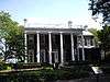 Admiral's House |
July 24, 1972 (#72000860) |
Nolan Park 40°41′25″N 74°00′50″W |
Governors Island | Used by the commanding officers of the Army and Coast Guard units. |
| 2 | Blackwell House | .jpg) Blackwell House |
February 25, 1972 (#72000862) |
501 Main Street, Roosevelt Island (formerly Welfare Island) 40°45′38″N 73°57′05″W |
Roosevelt Island | Built in 1796 by a descendant of the first English owner of the island |
| 3 | Block House |  Block House |
July 24, 1972 (#72000863) |
Nolan Park on Barry Road 40°41′20″N 74°00′51″W |
Governors Island | A small military prison on Governors Island. |
| 4 | Castle Williams |  Castle Williams |
July 31, 1972 (#72000864) |
Hay Road and Andes Road 40°41′34″N 74°01′11″W |
Governors Island | A circular 19th century fortification of red sandstone on the northwest point of Governors Island, part of a system of forts to protect New York City from naval attack. Now part of Governors Island National Monument. |
| 5 | Chapel of the Good Shepherd | 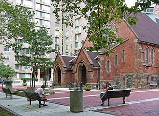 Chapel of the Good Shepherd |
March 16, 1972 (#72000865) |
543 Main Street 40°45′42″N 73°57′02″W |
Roosevelt Island | A historic Episcopal church designed by architect Frederick Clarke Withers, now known as the Good Shepherd Community Ecumenical Center |
| 6 | City Hospital | .jpg) City Hospital |
March 16, 1972 (#72000868) |
Between Road 3 and South Loop Road 40°45′11″N 73°57′31″W |
Roosevelt Island | Built in 1861 by James Renwick, Jr. to replace the earlier Penitentiary hospital. Demolished in 1994. |
| 7 | Fort Jay |  Fort Jay |
March 27, 1974 (#74001268) |
Quadrangle Road 40°41′29″N 74°00′59″W |
Governors Island | A 1794 coastal star fort, built to defend New York Harbor. Now part of Governors Island National Monument. |
| 8 | Governor's House | .jpg) Governor's House |
April 26, 1973 (#73001217) |
Building 2, Andes Road 40°41′27″N 74°00′48″W |
Governors Island | A historic house on Governors Island. |
| 9 | Governors Island | 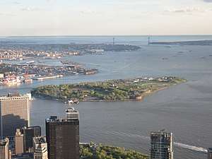 Governors Island |
February 4, 1985 (#85002435) |
Governors Island 40°41′26″N 74°01′00″W |
Governors Island | A 172-acre (70 ha) island in New York Harbor which has been expanded over time. Used by various military forces over time, it is now used for a variety of purposes. |
| 10 | Lighthouse | .jpg) Lighthouse |
March 16, 1972 (#72000876) |
North end of Roosevelt Island 40°46′22″N 73°56′26″W |
Roosevelt Island | An 1872 lighthouse located at the northeast tip of Roosevelt Island in the East River. |
| 11 | The Octagon | 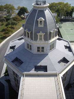 The Octagon |
March 16, 1972 (#72000880) |
888 Main Street 40°46′08″N 73°56′38″W |
Roosevelt Island | Originally serving as the main entrance to the New York City Lunatic Asylum, which opened in 1841, it was designed by Alexander Jackson Davis. |
| 12 | Smallpox Hospital | Smallpox Hospital |
March 16, 1972 (#72000881) |
E Road 40°45′06″N 73°57′36″W |
Roosevelt Island | Originally designed by architect James Renwick Jr., the 100-bed hospital opened in 1856, when the area was known as Blackwell's Island. Its ruins have been stabilized and preserved. |
| 13 | Statue of Liberty Enlightening the World | 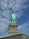 Statue of Liberty Enlightening the World |
September 14, 2017 (#100000829) |
Liberty Island, New York Harbor 40°41′21″N 74°02′40″W |
Liberty Island | The iconic statue named Liberty Enlightening the World |
| 14 | Statue of Liberty National Monument, Ellis Island and Liberty Island |  Statue of Liberty National Monument, Ellis Island and Liberty Island |
October 15, 1966 (#66000058) |
Liberty Island and Ellis Island, New York Harbor 40°41′38″N 74°02′37″W |
Liberty Island and Ellis Island | A National Monument that includes, Liberty Enlightening the World, commonly known as the Statue of Liberty, situated on Liberty Island, and the former immigration station at Ellis Island, including the Ellis Island Immigrant Hospital. |
| 15 | Strecker Memorial Laboratory | .jpg) Strecker Memorial Laboratory |
March 16, 1972 (#72000886) |
E Road 40°45′09″N 73°57′31″W |
Roosevelt Island | Built in 1892 to serve as a laboratory for City Hospital, it was "the first institution in the nation for pathological and bacteriological research." The building was designed by architects Frederick Clarke Withers and Walter Dickson in the Romanesque Revival style. |
See also
| Wikimedia Commons has media related to National Register of Historic Places in Manhattan. |
- County: National Register of Historic Places listings in New York County, New York
- State: National Register of Historic Places listings in New York
- Municipal: List of New York City Designated Landmarks in Manhattan on Islands
References
- The latitude and longitude information provided in this table was derived originally from the National Register Information System, which has been found to be fairly accurate for about 99% of listings. Some locations in this table may have been corrected to current GPS standards.
- "National Register of Historic Places: Weekly List Actions". National Park Service, United States Department of the Interior. Retrieved on June 26, 2020.
- Numbers represent an ordering by significant words. Various colorings, defined here, differentiate National Historic Landmarks and historic districts from other NRHP buildings, structures, sites or objects.
- The eight-digit number below each date is the number assigned to each location in the National Register Information System database, which can be viewed by clicking the number.
| Topics |  | |
|---|---|---|
| Lists by county |
| |
| Lists by city | ||
| Other lists | ||
| ||
This article is issued from Wikipedia. The text is licensed under Creative Commons - Attribution - Sharealike. Additional terms may apply for the media files.