National Register of Historic Places listings in Otsego County, New York
List of the National Register of Historic Places listings in Otsego County, New York
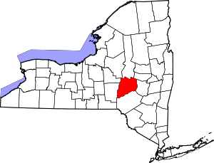
Location of Otsego County in New York
This is intended to be a complete list of properties and districts listed on the National Register of Historic Places in Otsego County, New York. The locations of National Register properties and districts (at least for all showing latitude and longitude coordinates below) may be seen in a map by clicking on "Map of all coordinates".[1] One property, Hyde Hall, is further designated a National Historic Landmark of the United States.
- This National Park Service list is complete through NPS recent listings posted June 19, 2020.[2]
| Albany (Albany) – Allegany – Bronx – Broome – Cattaraugus – Cayuga – Chautauqua – Chemung – Chenango – Clinton – Columbia – Cortland – Delaware – Dutchess (Poughkeepsie, Rhinebeck) – Erie (Buffalo) – Essex – Franklin – Fulton – Genesee – Greene – Hamilton – Herkimer – Jefferson – Kings – Lewis – Livingston – Madison – Monroe (Rochester) – Montgomery – Nassau – New York (Below 14th Street, 14th to 59th Streets, 59th to 110th Streets, Above 110th Street, Islands) – Niagara – Oneida – Onondaga – Ontario – Orange – Orleans – Oswego – Otsego – Putnam – Queens – Rensselaer – Richmond – Rockland – St. Lawrence – Saratoga – Schenectady – Schoharie – Schuyler – Seneca – Steuben – Suffolk – Sullivan – Tioga – Tompkins – Ulster – Warren – Washington – Wayne – Westchester (Northern, Southern, New Rochelle, Peekskill, Yonkers) – Wyoming – Yates |
Listings county-wide
| [3] | Name on the Register | Image | Date listed[4] | Location | City or town | Description |
|---|---|---|---|---|---|---|
| 1 | All Saints Chapel and Morris Family Burial Ground | November 24, 1997 (#97001455) |
State Route 51, 3 mi (4.8 km) south of Morris 42°30′33″N 75°17′19″W |
Morris | ||
| 2 | Baker Octagon Barn | September 29, 1984 (#84002887) |
State Route 28 42°49′25″N 75°00′56″W |
Richfield Springs | ||
| 3 | Bassett Family House | August 11, 2004 (#04000823) |
2399 Main St. 42°34′49″N 75°03′31″W |
Mt. Vision | ||
| 4 | Beardslee Farm | June 30, 2000 (#00000748) |
State Route 80 at Cty Rd. 18 42°37′34″N 75°19′14″W |
Pittsfield | ||
| 5 | Bresee Hall | 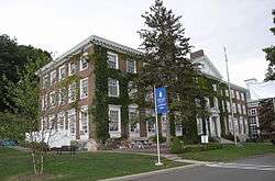 Bresee Hall |
April 12, 1984 (#84002892) |
Hardwick Dr. 42°27′31″N 75°04′20″W |
Oneonta | |
| 6 | Chapin Memorial Church | 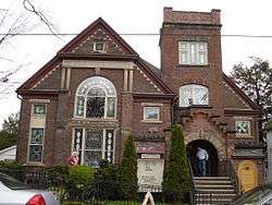 Chapin Memorial Church |
September 12, 2002 (#02001049) |
12 Ford Ave. 42°42′24″N 74°58′36″W |
Oneonta | |
| 7 | Cherry Valley Village Historic District | 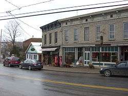 Cherry Valley Village Historic District |
April 28, 1988 (#88000472) |
Roughly bounded by Alden St. and Montgomery St., Maple Ave. and Elm St., and Main St. 42°47′48″N 74°45′09″W |
Cherry Valley | Boundary increase of 9,105 acres (36.85 km2) added as Lindesay Patent Rural Historic District in 1995 (NRHP Reference#: 95001024). |
| 8 | Church Street Historic District | June 4, 1997 (#97000532) |
Roughly bounded by Church, Sylvan, Gould, and Warren Sts. 42°51′21″N 74°59′02″W |
Richfield Springs | ||
| 9 | Cooperstown Historic District |  Cooperstown Historic District |
November 18, 1980 (#80002742) |
State Route 28, State Route 80, and Main St. 42°42′07″N 74°55′32″W |
Cooperstown | Boundary increase to include Fenimore Farm Stone Agricultural Buildings in 1997 (NRHP Reference#: 97000937). |
| 10 | The Cornfield | September 12, 2002 (#02001047) |
655 Cty Rd. 26 42°27′21″N 75°03′42″W |
Fly Creek | ||
| 11 | East Main Street Historic District | 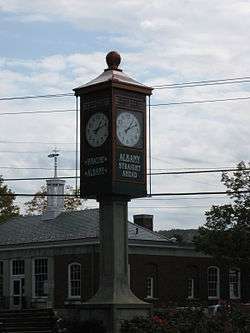 East Main Street Historic District |
November 7, 1995 (#95001282) |
Roughly, E. Main St. from Church St. to the Richfield Springs reservoirs 42°51′08″N 74°58′33″W |
Richfield Springs | |
| 12 | East Springfield Union School | 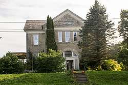 East Springfield Union School |
April 26, 1996 (#96000483) |
Approximately 0.5 mi (0.80 km) east of the junction of US 20 and Co. Rd. 31 42°49′49″N 74°48′45″W |
East Springfield | |
| 13 | Fairchild Mansion | 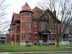 Fairchild Mansion |
February 12, 1974 (#74001294) |
318 Main St. 42°27′21″N 75°03′34″W |
Oneonta | |
| 14 | Warren Ferris House | March 8, 2016 (#16000063) |
7637 NY 80 42°49′39″N 74°52′54″W |
Springfield Center | Exemplary 1894 Queen Anne house by local builder | |
| 15 | Fly Creek Grange No. 844 |  Fly Creek Grange No. 844 |
February 25, 2004 (#04000097) |
208 Cemetery Rd. 42°43′00″N 74°59′02″W |
Fly Creek | |
| 16 | Fly Creek Historic District |  Fly Creek Historic District |
November 8, 2006 (#06001004) |
State Route 28, State Route 80, County Road 26, Cemetery Rd., Goose St. Allison Rd., and Bissell Rd. 42°43′11″N 74°58′38″W |
Fly Creek | |
| 17 | Fly Creek Methodist Church | 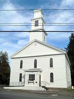 Fly Creek Methodist Church |
August 8, 1996 (#96000859) |
Co. Rt. 26, north of the junction with State Route 28 42°43′09″N 74°58′59″W |
Fly Creek | |
| 18 | Ford Block | 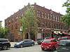 Ford Block |
September 7, 1984 (#84002893) |
188-202 Main St. 42°27′14″N 75°03′43″W |
Oneonta | |
| 19 | Fortin Site |  Fortin Site |
November 28, 1980 (#80002743) |
Address Restricted |
Oneonta | |
| 20 | Gilbertsville Historic District | May 17, 1974 (and 82001232 #74001293 and 82001232) |
Originally roughly bounded by Marion Ave., Cliff and Green Sts., Grover and Sylvan Sts.; later extended to approximate village borders 42°28′16″N 75°19′38″W |
Gilbertsville | Boundary increase in 1982 (NRHP Reference#: 82001232). | |
| 21 | Gilbertsville Water Works | May 18, 2011 (#11000290) |
Reservoir Rd. 42°29′37″N 75°23′23″W |
Gilbertsville vicinity | ||
| 22 | Glimmerglass Historic District |  Glimmerglass Historic District |
September 24, 1999 (#99001136) |
Otsego Lake and Environs 42°45′20″N 74°54′24″W |
Cooperstown | |
| 23 | Hartwick Historic District |  Hartwick Historic District |
August 20, 2013 (#13000610) |
Roughly along New York State Route 205, County Road 11, and Weeks Road 42°39′35″N 75°03′03″W |
Hartwick | |
| 24 | Hyde Hall | 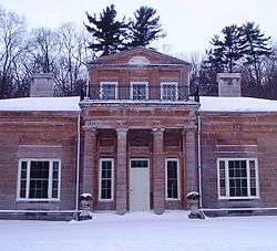 Hyde Hall |
October 7, 1971 (#71000555) |
South of Springfield Center in Glimmerglass State Park 42°47′38″N 74°52′25″W |
Springfield Center | |
| 25 | Hyde Hall Covered Bridge | 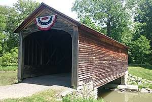 Hyde Hall Covered Bridge |
December 17, 1998 (#98001539) |
East Lake Rd., over Shadow Brook 42°47′25″N 74°51′50″W |
East Springfield | |
| 26 | Kenyon Residences |  Kenyon Residences |
February 26, 2004 (#04000093) |
60 and 62 Main St. 42°34′45″N 75°03′30″W |
Mt. Vision | |
| 27 | Lunn-Musser Octagon Barn | September 29, 1984 (#84002897) |
South of Garrattsville 42°37′39″N 75°09′26″W |
Garrattsville | ||
| 28 | Major's Inn and Gilbert Block | 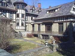 Major's Inn and Gilbert Block |
April 11, 1973 (#73001249) |
Both sides of Commercial St. near State Route 51 42°28′17″N 75°19′39″W |
Gilbertsville | |
| 29 | Andrew Mann Inn | 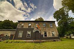 Andrew Mann Inn |
January 10, 1980 (#80002747) |
33 Riverside Rd. 42°19′14″N 75°23′28″W |
Unadilla | |
| 30 | Mathewson–Bice Farmhouse and Mathewson Family Cemetery | May 28, 2013 (#13000331) |
204 Bice Rd. 42°41′38″N 74°59′03″W |
Cooperstown vicinity | Late 18th-century farmhouse's design reflects owners' New England origins; family cemetery dates to 1813. | |
| 31 | Middlefield District No. 1 School | August 13, 1987 (#87001363) |
CR 35 42°41′23″N 74°49′46″W |
Cooperstown | ||
| 32 | Middlefield Hamlet Historic District | 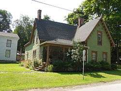 Middlefield Hamlet Historic District |
July 11, 1985 (#85001523) |
CR 35, Rezen, Whiteman, and Long Patent Rds. 42°41′14″N 74°50′29″W |
Middlefield | |
| 33 | Morris-Lull Farm | December 7, 2005 (#05001389) |
133 Peet Rd. 42°31′24″N 75°14′57″W |
Morris | ||
| 34 | Morris Village Historic District | February 20, 2013 (#13000031) |
Main, Lake, Broad, Grove & Church, 42°32′55″N 75°14′43″W |
Morris | Intact core of 19th-century village settled by refugees from Revolutionary France | |
| 35 | Municipal Building | 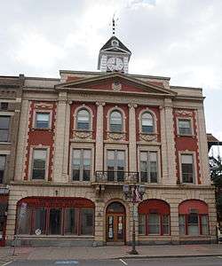 Municipal Building |
October 29, 1982 (#82001233) |
238-242 Main St. 42°27′16″N 75°03′41″W |
Oneonta | |
| 36 | Benjamin D. North House | July 11, 1985 (#85001499) |
State Route 166, The Plank Rd. 42°42′12″N 74°50′08″W |
Middlefield | ||
| 37 | Old Hartwick Village Cemetery | August 20, 2013 (#13000611) |
2862 County Road 11 42°39′34″N 75°03′13″W |
Hartwick vicinity | ||
| 38 | Old Post Office |  Old Post Office |
November 17, 1978 (#78001895) |
Main St. 42°27′17″N 75°03′38″W |
Oneonta | |
| 39 | Oneonta Armory | 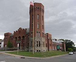 Oneonta Armory |
March 2, 1995 (#95000078) |
4 Academy St. 42°27′03″N 75°03′56″W |
Oneonta | |
| 40 | Oneonta Downtown Historic District | 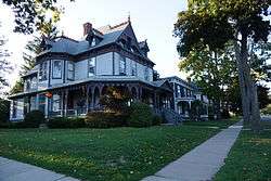 Oneonta Downtown Historic District |
December 4, 2003 (#03001245) |
Main, Chestnut, Dietz, Market, Elm, Water, Wall, S. Main Sts. 42°27′15″N 75°03′44″W |
Oneonta | |
| 41 | Oneonta Theatre | 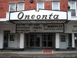 Oneonta Theatre |
May 22, 2002 (#02000555) |
47 Chestnut St. 42°27′09″N 75°04′23″W |
Oneonta | |
| 42 | Otsdawa Baptist Church | March 6, 2002 (#02000143) |
Cty Rd. 8 42°29′11″N 75°10′25″W |
Otsdawa | ||
| 43 | Otsdawa Creek Site | Otsdawa Creek Site |
July 22, 1980 (#80002746) |
Address Restricted |
Otego | |
| 44 | Otsego County Courthouse | 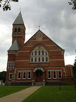 Otsego County Courthouse |
June 20, 1972 (#72000902) |
193 Main St. 42°42′03″N 74°55′48″W |
Cooperstown | |
| 45 | Roseboom Historic District | 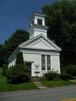 Roseboom Historic District |
November 19, 1998 (#98001394) |
Roughly along State Route 166, State Route 165, Beaver, John Deer and Gage Rds. 42°44′21″N 74°46′16″W |
Roseboom | |
| 46 | Russ-Johnsen Site | Russ-Johnsen Site |
July 22, 1980 (#80002748) |
Address Restricted |
Unadilla | |
| 47 | Rutherford House | December 3, 2019 (#100004733) |
26 East St. 42°41′52″N 75°14′32″W |
Edmeston | Intact 1868 Italianate villa built for local doctor; later used as hotel | |
| 48 | St. Mary's Episcopal Church Complex | March 17, 2015 (#15000094) |
7690 NY 80 42°49′45″N 74°52′44″W |
Springfield Center | Fin de siècle church buildings in unusual combination of Shingle and Gothic Revival styles. | |
| 49 | South Worcester Historic District |  South Worcester Historic District |
November 5, 1992 (#92001563) |
Junction of County Route 40 and County Route 39 and west along Route 40 42°31′01″N 74°45′25″W |
South Worcester | |
| 50 | Springfield Center Elementary School | August 24, 2011 (#11000601) |
129 County Road 29A 42°49′56″N 74°51′46″W |
Springfield Center | ||
| 51 | Stonehouse Farm | November 19, 1980 (#80002744) |
East of Oneonta on State Route 7 42°28′14″N 75°00′08″W |
Oneonta | ||
| 52 | Sunnyside | March 10, 1988 (#88000211) |
72 E. Main St. 42°51′07″N 74°58′42″W |
Richfield Springs | ||
| 53 | Swart-Wilcox House | 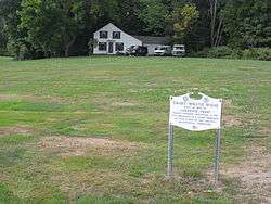 Swart-Wilcox House |
May 24, 1990 (#90000817) |
Junction of Wilcox Ave. and Henry St. 42°26′38″N 75°04′15″W |
Oneonta | |
| 54 | The Tepee | 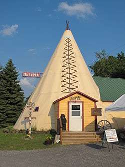 The Tepee |
August 18, 2011 (#11000543) |
7632 US 20 42°48′28″N 74°41′04″W |
Cherry Valley vicinity | |
| 55 | Tianderah | November 2, 1978 (#78001894) |
Off State Route 51 42°27′50″N 75°18′54″W |
Gilbertsville | ||
| 56 | Tunnicliff-Jordan House | September 24, 2010 (#10000796) |
68–72 Main Street 42°51′09″N 74°58′38″W |
Richfield Springs | ||
| 57 | Twentieth Century Steam Riding Gallery No. 409 | January 16, 1998 (#97001618) |
Race St. 42°32′48″N 74°49′37″W |
Schenevus | ||
| 58 | Unadilla Forks School | August 28, 1998 (#98001117) |
113 State Route 18A 42°50′35″N 75°14′13″W |
Unadilla Forks | ||
| 59 | Unadilla Village Historic District |  Unadilla Village Historic District |
September 4, 1992 (#92001079) |
Roughly, Main St. from Hopkins St. to Butternut Rd. and Bridge St. from Main to Watson St. 42°19′24″N 75°18′32″W |
Unadilla | |
| 60 | Unadilla Waterworks | September 4, 1992 (#92001080) |
Junction of Kilkenny Rd. and Clifton St. and junction of Martin Brook Rd. and Rod & Gun Club Rd. 42°20′22″N 75°19′03″W |
Unadilla | ||
| 61 | US Post Office-Cooperstown | 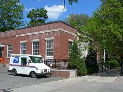 US Post Office-Cooperstown |
November 17, 1988 (#88002473) |
28-40 Main St. 42°42′01″N 74°55′24″W |
Cooperstown | |
| 62 | US Post Office-Richfield Springs | 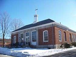 US Post Office-Richfield Springs |
May 11, 1989 (#88002422) |
152 Main St.[5] 42°51′11″N 74°59′04″W |
Richfield Springs | |
| 63 | Lemuel F. Vibber House | June 21, 2016 (#16000393) |
302 Butternut Rd. 42°50′33″N 74°58′30″W |
Richfield vicinity | Early 19th-century residence is only remnant of early industrial hamlet of Federal Corner | |
| 64 | Walnut Street Historic District | Walnut Street Historic District |
July 30, 1980 (#80002745) |
Ford Ave., Walnut, Dietz, Elm and Maple Sts. 42°27′25″N 75°03′42″W |
Oneonta | |
| 65 | West Burlington Memorial Church | January 16, 2001 (#00001661) |
State Route 80 42°42′25″N 75°11′16″W |
West Burlington | ||
| 66 | West Main Street-West James Street Historic District | 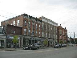 West Main Street-West James Street Historic District |
March 17, 1994 (#94000257) |
Roughly, along W. Main, W. James, Elm and Center Sts. and Taylor Ave. 42°51′12″N 74°59′19″W |
Richfield Springs | |
| 67 | The White House | September 4, 2012 (#12000598) |
108 White House Rd. 42°41′14″N 75°03′18″W |
Hartwick | ||
| 68 | George I. Wilber House | 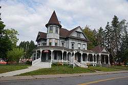 George I. Wilber House |
November 15, 2000 (#00001381) |
11 Ford Ave. 42°27′19″N 75°03′43″W |
Oneonta | |
| 69 | Women's Community Club of South Valley | February 1, 1999 (#98001617) |
472 Kirshman Hill Rd. 42°42′21″N 74°42′40″W |
South Valley | ||
| 70 | Worcester Historic District | 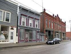 Worcester Historic District |
June 10, 1975 (#75001221) |
Both sides of Main St. (State Route 7) between Decatur and Cook Sts. 42°35′31″N 74°45′00″W |
Worcester | |
| 71 | Roswell Wright House | 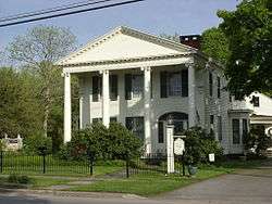 Roswell Wright House |
September 1, 1988 (#88001271) |
25 Main St. 42°19′32″N 75°18′38″W |
Unadilla | |
| 72 | Zion Episcopal Church Complex and Harmony Cemetery | 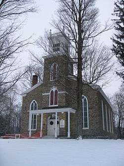 Zion Episcopal Church Complex and Harmony Cemetery |
November 24, 1997 (#97001456) |
East of Morris, State Route 51 42°32′56″N 75°14′35″W |
Morris |
Former listing
| [3] | Name on the Register | Image | Date listed | Date removed | Location | City or town | Summary |
|---|---|---|---|---|---|---|---|
| 1 | Oneonta State Normal School | 1977 (#77001582) | 1977 | State St. |
Oneonta | Listing is for the Old Main building, which was demolished in 1977. |
See also
| Wikimedia Commons has media related to National Register of Historic Places in Otsego County, New York. |
References
- The latitude and longitude information provided in this table was derived originally from the National Register Information System, which has been found to be fairly accurate for about 99% of listings. Some locations in this table may have been corrected to current GPS standards.
- "National Register of Historic Places: Weekly List Actions". National Park Service, United States Department of the Interior. Retrieved on June 19, 2020.
- Numbers represent an ordering by significant words. Various colorings, defined here, differentiate National Historic Landmarks and historic districts from other NRHP buildings, structures, sites or objects.
- The eight-digit number below each date is the number assigned to each location in the National Register Information System database, which can be viewed by clicking the number.
- Address based on USPS website. Accessed April 1, 2016.
| Topics |  | |
|---|---|---|
| Lists by county |
| |
| Lists by city | ||
| Other lists | ||
| ||
This article is issued from Wikipedia. The text is licensed under Creative Commons - Attribution - Sharealike. Additional terms may apply for the media files.