Seventh Avenue station (BMT Brighton Line)
Seventh Avenue is a station on the BMT Brighton Line of the New York City Subway, located at the intersection of Seventh Avenue, Park Place and Flatbush Avenue in Park Slope and Prospect Heights, Brooklyn. The station is served by the Q train at all times and by the B train on weekdays only.
7 Avenue | |||||||||
|---|---|---|---|---|---|---|---|---|---|
 | |||||||||
| Station statistics | |||||||||
| Address | Seventh Avenue, Park Place & Flatbush Avenue Brooklyn, NY 11217 | ||||||||
| Borough | Brooklyn | ||||||||
| Locale | Park Slope, Prospect Heights | ||||||||
| Coordinates | 40.679352°N 73.973694°W | ||||||||
| Division | B (BMT) | ||||||||
| Line | BMT Brighton Line | ||||||||
| Services | B Q | ||||||||
| Transit connections | |||||||||
| Structure | Underground | ||||||||
| Platforms | 2 side platforms | ||||||||
| Tracks | 2 | ||||||||
| Other information | |||||||||
| Opened | August 1, 1920[1] | ||||||||
| Station code | 041[2] | ||||||||
| Wireless service | |||||||||
| Opposite-direction transfer available | Yes | ||||||||
| Traffic | |||||||||
| Passengers (2019) | 3,103,599[4] | ||||||||
| Rank | 162 out of 424[4] | ||||||||
| Station succession | |||||||||
| Next north | Atlantic Avenue–Barclays Center: B | ||||||||
| Next south | Prospect Park: B | ||||||||
| |||||||||
| |||||||||
| |||||||||


%26groups%3D_1b1d3cf58d8eb2bee734010ee216688b9fe330f4.svg)
History
Although on the BMT Brighton Line, Seventh Avenue was built almost fifty years after the main segment of the line from Prospect Park to Brighton Beach opened in 1878. Prior to its opening, trains on the line used what is now the Franklin Avenue Shuttle and a connection to the elevated BMT Fulton Street Line on their way to the line's terminus at Fulton Ferry in Brooklyn or Park Row in Manhattan.[5]
The station is a product of the Dual Contracts, a 1913 group of contracts that provided for the construction of BMT (as well as IRT) underground lines in Manhattan and Queens. The first of these was the BMT Broadway Line which ran from its northern terminus at Times Square–42nd Street to its southern end at Whitehall Street in 1918. The Montague Street Tunnel, which linked Whitehall Street to Prospect Park station and would be the location for Seventh Avenue, opened on August 1, 1920, and moved trains from the elevated Franklin Avenue Line to the new underground line.[1]
During the 1964–1965 fiscal year, the platforms at Seventh Avenue, along with those at six other stations on the Brighton Line, were lengthened to 615 feet (187 m) to accommodate a ten-car train of 60 feet (18 m)-long IND cars, or a nine-car train of 67 feet (20 m)-long BMT cars.[6]
Station layout
| G | Street level | Exit/entrance |
| M | Mezzanine | Fare control, station agent |
| P Platform level |
IRT Northbound local | ← |
| Side platform | ||
| Northbound | ← ← | |
| Southbound | | |
| Side platform | ||
| IRT Southbound local | | |
| IRT Express Tracks[7] | Northbound express | ← |
| Southbound express | | |
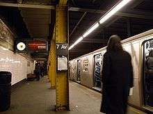
The Seventh Avenue station has two tracks and two side platforms.[8] Each platform has two closed staircases that lead to a closed portion of the mezzanine above the platforms. Just north of the station, next to the southbound track, an opening in the tunnel allows a view of the southbound local track of the IRT Eastern Parkway Line. At this point in the complex Flatbush Avenue tunnel, the IRT local tracks are to the outside of the Brighton line tracks, while the IRT express tracks run at a lower level, below the station, with emergency exits furnished from same on both platforms at this station.[7]
This is one of two stations on the B train named "Seventh Avenue"; the other is Seventh Avenue–53rd Street on the IND Sixth Avenue Line in Manhattan.
Exits
This station has two entrances and exits. One stair goes up to the south sidewalk of Park Place east of Flatbush Avenue, while the other stair goes to the south sidewalk of Flatbush Avenue southeast of Park Place.[9]
References
- "New Subways Add Seven More Miles to BRT on Aug 1". Brooklyn Daily Eagle. July 25, 1920. Retrieved August 19, 2016 – via newspapers.com.
- "Station Developers' Information". Metropolitan Transportation Authority. Retrieved June 13, 2017.
- "NYC Subway Wireless – Active Stations". Transit Wireless Wifi. Retrieved November 13, 2019.
- "Facts and Figures: Annual Subway Ridership 2014–2019". Metropolitan Transportation Authority. 2020. Retrieved May 26, 2020.
- 1912 BMT network map NYCSubway Retrieved 2009-07-20
- Annual Report 1964–1965. New York City Transit Authority. 1965.
- Dual Contracts construction map
- Dougherty, Peter (2006) [2002]. Tracks of the New York City Subway 2006 (3rd ed.). Dougherty. OCLC 49777633 – via Google Books.
- "MTA Neighborhood Maps: Park Slope/Prospect Park" (PDF). mta.info. Metropolitan Transportation Authority. 2015. Retrieved 2 August 2015.
External links
- nycsubway.org – BMT Brighton Line: 7th Avenue
- Station Reporter — B Train
- Station Reporter — Q Train
- The Subway Nut — 7th Avenue Pictures
- Park Place & Carlton Avenue entrance north of Flatbush Avenue from Google Maps Street View
- Entrance near Seventh Avenue from Google Maps Street View
- Platform from Google Maps Street View
| Brighton Line |
|
|---|---|
| |