City Hall station (BMT Broadway Line)
City Hall is a local station on the BMT Broadway Line of the New York City Subway in Tribeca and Civic Center, Manhattan. It is served by the R train at all times except late nights, when the N train takes over service. The W train also serves this station on weekdays.
City Hall | |||||||||||
|---|---|---|---|---|---|---|---|---|---|---|---|
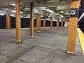
 The renovated platform; the wall on the right is for maintenance closets | |||||||||||
| Station statistics | |||||||||||
| Address | Murray Street & Broadway New York, NY 10007 | ||||||||||
| Borough | Manhattan | ||||||||||
| Locale | Civic Center, Tribeca | ||||||||||
| Coordinates | 40.71324°N 74.007082°W | ||||||||||
| Division | B (BMT) | ||||||||||
| Line | BMT Broadway Line | ||||||||||
| Services | N R W | ||||||||||
| Transit connections | |||||||||||
| Structure | Underground | ||||||||||
| Levels | 2 (lower level not for passenger service) | ||||||||||
| Platforms | 2 island platforms (1 on upper level, 1 on lower level) | ||||||||||
| Tracks | 5 (2 on upper level, 3 on lower level) | ||||||||||
| Other information | |||||||||||
| Opened | January 5, 1918[1] | ||||||||||
| Station code | 020[2] | ||||||||||
| Wireless service | |||||||||||
| Opposite-direction transfer available | Yes | ||||||||||
| Traffic | |||||||||||
| Passengers (2019) | 1,710,380[4] | ||||||||||
| Rank | 273 out of 424[4] | ||||||||||
| Station succession | |||||||||||
| Next north | Canal Street: N | ||||||||||
| Next south | Cortlandt Street: N | ||||||||||
| |||||||||||
| |||||||||||
| |||||||||||


%26groups%3D_5ed18441b7e97f30eaa23c3a2d1e74022a6354fe.svg)
History
The Brooklyn Rapid Transit Company's, later Brooklyn–Manhattan Transit Corporation (BMT)'s, Broadway Line was built as four tracks south to City Hall, where the local tracks were to terminate on the upper level, and the express tracks were to use the lower level, curving through Vesey Street into Church Street. However, the final plan had the express tracks splitting at Canal Street and passing under the northbound local track to the Manhattan Bridge. The tracks via Canal Street and the Manhattan Bridge were supposed to be a crosstown line continuing further west, but the Broadway Line connection allowed through operation from the BMT Fourth Avenue Line in Brooklyn to go into operation more than a year earlier than would otherwise have been possible.[5] The tunnel south of City Hall was rebuilt to bring the upper local tracks down to the lower level north of Vesey Street, and the lower level at City Hall was never used for passenger service, instead being used for train storage.[6][7][8]
The Broadway Line, initially comprising a short section north of Canal Street, was extended south to Rector Street on January 5, 1918, including the City Hall station. Local service henceforth ran between Times Square and Rector Street.[9]
Station layout
| G | Street level | Exit/entrance | ||
| B1 Upper platforms |
Northbound | ← ← ← | ||
| Island platform | ||||
| ||||
| Island platform | ||||
| Southbound | | |||
| B2 | Mezzanine | Storage area | ||
| B3 Lower platforms |
Track B4 | No regular service | ||
| Uncompleted island platform, not in service | ||||
| Track BM | No regular service | |||
| Island platform, not in service | ||||
| Track B3 | No regular service | |||
Upper level
There are two tracks and a very wide island platform. The northbound track is located under City Hall Park, while the southbound track is under the east side of Broadway.
There is an active tower at the north end, with a window that lets any waiting passengers observe Transit Authority goings-on. The platform tapers off toward the southern end, where the northbound and southbound portions join. The station's configuration, and the wide-open staircases to the sky above, is responsible for another distinguishing feature: the number of birds that fly into and around the station.
This station was overhauled in the late 1970s, changing the station's structure and overall appearance. It replaced the original wall tiles, old signs, and incandescent lighting with more modern wall tiles, signs and fluorescent lights, as well as fixing staircases and platform edges.
Before the new City Hall master tower was built, there was a provision at the north end of the upper level for a diamond crossover (which has existed since the construction of this station, when the upper level platform was to be a terminal) which is now occupied by a relay room. At the south end of the station, the uptown track curves away from the wall; this dates from the original construction when the upper level was converted from a terminal, with presumably a straight line, to a through station with a single two-track tunnel.[10]
Immediately south of this station, the line utilizes a sharp reverse curve, first turning west under Vesey Street, then turning south under Church Street toward Cortlandt Street.[11]
Exits
The fare control area is located in the center of the platform and fenced off from the rest of the platform area, has exits on either end. At the north end, two exits lead to the east side of Broadway at Warren Street, and at the south end, one exit leads to the east side of Broadway at Murray Street. Passengers enter from the sidewalk adjacent to City Hall Park directly onto the wide island platform on the upper level.[12]
An exit at the south end of the platform led to the Woolworth Building, but this was closed in 1982 due to concerns over crime.[13]
Lower level
The City Hall station is a bi-level station, with an unused two-island platform, three-track lower level reachable from a single staircase from about the center of the in-use upper platform. The staircase leads to the western platform; the eastern platform was never finished and does not have a usable stairway. The middle track in the lower level station was to be used for short turns from either direction depending on the service pattern, with a layout much like that at Whitehall Street–South Ferry station further south.[7]
It was initially intended that the local trains were to terminate on the upper level, while the express trains using the lower level would continue on through lower Manhattan and then through the Montague Street Tunnel. However, plans were changed before construction ended. As a result, the lower level of the station is unused (except for non-rush hour storage of trains), as are the stub-end center express tracks at Canal Street on its upper level (the connections to which were instead "temporarily" rerouted to the Manhattan Bridge for service across that bridge). Another effect of this change is that the southern end of the upper level station slopes downward. This is a result of platform lengthening and rerouting the upper level downward toward the south, rather than letting the lower level stay at the same elevation and continue south through lower Manhattan. The lower level floor continues south of the station until it disappears under the increasingly low ceiling under the ramps carrying the upper level downgrade.[14] The lower level was never used for passenger service or even finished with tiles and signage. Only the western platform was fully completed; the shorter eastern platform was never finished.[7]
The lower level is only long enough to store 480-foot-long (150 m) 8-car trains, with cars of 60 feet (18 m) lengths, like the platforms in the BMT Eastern Division. Only two of the three tracks are usable: the westernmost and the center tracks, which are used to store trains. The easternmost track on the lower level is unusable as it has no third rail; it was removed at an unknown date.[15]
Lower Manhattan transit | ||||||||||||||||||||||||||||||||||||||||||||||||||||||||||||||||||||||||||||||||||||||||||||||||||
|---|---|---|---|---|---|---|---|---|---|---|---|---|---|---|---|---|---|---|---|---|---|---|---|---|---|---|---|---|---|---|---|---|---|---|---|---|---|---|---|---|---|---|---|---|---|---|---|---|---|---|---|---|---|---|---|---|---|---|---|---|---|---|---|---|---|---|---|---|---|---|---|---|---|---|---|---|---|---|---|---|---|---|---|---|---|---|---|---|---|---|---|---|---|---|---|---|---|---|
| ||||||||||||||||||||||||||||||||||||||||||||||||||||||||||||||||||||||||||||||||||||||||||||||||||
In popular culture
In Chuck Hogan and Guillermo del Toro's novel The Strain, it is by trekking through the disused City Hall station's lower levels that Dr. Goodweather, Setrakian and Fet find their way towards the Master's lair.[16] Though not mentioned by name, the station also appears in episode 11 of the TV series' first season.
Gallery
 Murray Street stair (Note:
 Southern end of platform
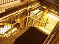 Staircase to the lower level
References
- The New York Times, Open New Subway to Times Square, January 6, 1918
- "Station Developers' Information". Metropolitan Transportation Authority. Retrieved June 13, 2017.
- "NYC Subway Wireless – Active Stations". Transit Wireless Wifi. Retrieved November 13, 2019.
- "Facts and Figures: Annual Subway Ridership 2014–2019". Metropolitan Transportation Authority. 2020. Retrieved May 26, 2020.
- Report of the Public Service Commission for the First District of the State of New York. The Public Service Commission for the First District of the State of New York. 1918. p. 74.
- Report of the Public Service Commission of The First District of the State Of New York For The Year Ending December 31, 1915. New York State Public Service Commission. January 1, 1916.
- Joseph Brennan, Abandoned Stations: City Hall (BMT) lower level, accessed March 21, 2007
- Cudahy, Brian J. (January 1, 1995). Under the Sidewalks of New York: The Story of the Greatest Subway System in the World. Fordham University Press. p. 132. ISBN 978-0-8232-1618-5.
- "Open New Subway To Times Square; Brooklyn Directly Connected with Wholesale and Shopping Districts of New York. Nickel Zone Is Extended. First Train in Broadway Tube Makes Run from Rector Street in 17 Minutes. Cost About $20,000,000 Rapid Transit from Downtown to Hotel and Theatre Sections Expected to Affect Surface Lines. Increases Five-Cent Zone. First Trip to Times Square. Benefits to Brooklyn" (PDF). The New York Times. January 6, 1918. ISSN 0362-4331. Retrieved November 5, 2016.
- http://images.nycsubway.org/i1000/img_1228.jpg
- Dougherty, Peter (2020). Tracks of the New York City Subway 2020 (16th ed.). Dougherty. OCLC 1056711733.
- "MTA Neighborhood Maps: Lower Manhattan" (PDF). mta.info. Metropolitan Transportation Authority. 2015. Retrieved August 21, 2015.
- Buder, Leonard (June 26, 1983). "Coping with Crime in Office Buildings". The New York Times. ISSN 0362-4331. Retrieved January 23, 2019.
- http://ltvsquad.com/2014/06/16/tomb-of-the-unnamed-repent-tunnel/
- http://www.nycsubway.org/perl/show?31845
- Chuck Hogan & Guillermo del Toro, The Strain. ISBN 006-1-5582-3-0. 2009, pp. 360—385
Further reading
- Stookey, Lee (1994). Subway ceramics : a history and iconography of mosaic and bas relief signs and plaques in the New York City subway system. Brattleboro, Vt: L. Stookey. ISBN 978-0-9635486-1-0. OCLC 31901471.
External links
| Wikimedia Commons has media related to City Hall (BMT Broadway Line). |
- nycsubway.org – BMT Broadway Subway: City Hall
- Station Reporter — N Train
- Station Reporter — R Train
- Abandoned Stations — City Hall (BMT) lower level
- Broadway and Murray Street entrance from Google Maps Street View
- Broadway and Warren Street entrance from Google Maps Street View
- Platform from Google Maps Street View
| Government buildings |
|  | |||||
|---|---|---|---|---|---|---|---|
| Non-government buildings |
| ||||||
| Other spaces | |||||||
| Education | |||||||
| Transport |
| ||||||
See also: Manhattan Community Board 1 | |||||||