National Register of Historic Places listings in Tioga County, New York
List of the National Register of Historic Places listings in Tioga County, New York
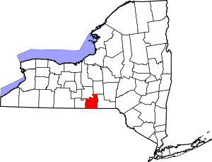
Location of Tioga County in New York
This is intended to be a complete list of properties and districts listed on the National Register of Historic Places in Tioga County, New York. The locations of National Register properties and districts (at least for all showing latitude and longitude coordinates below) may be seen in a map by clicking on "Map of all coordinates".[1]
- This National Park Service list is complete through NPS recent listings posted June 19, 2020.[2]
| Albany (Albany) – Allegany – Bronx – Broome – Cattaraugus – Cayuga – Chautauqua – Chemung – Chenango – Clinton – Columbia – Cortland – Delaware – Dutchess (Poughkeepsie, Rhinebeck) – Erie (Buffalo) – Essex – Franklin – Fulton – Genesee – Greene – Hamilton – Herkimer – Jefferson – Kings – Lewis – Livingston – Madison – Monroe (Rochester) – Montgomery – Nassau – New York (Below 14th Street, 14th to 59th Streets, 59th to 110th Streets, Above 110th Street, Islands) – Niagara – Oneida – Onondaga – Ontario – Orange – Orleans – Oswego – Otsego – Putnam – Queens – Rensselaer – Richmond – Rockland – St. Lawrence – Saratoga – Schenectady – Schoharie – Schuyler – Seneca – Steuben – Suffolk – Sullivan – Tioga – Tompkins – Ulster – Warren – Washington – Wayne – Westchester (Northern, Southern, New Rochelle, Peekskill, Yonkers) – Wyoming – Yates |
Listings county-wide
| [3] | Name on the Register | Image | Date listed[4] | Location | City or town | Description |
|---|---|---|---|---|---|---|
| 1 | Lyman P. Akins House | July 2, 1984 (#84003067) |
W. Creek Rd. 42°18′53″N 76°14′56″W |
Berkshire | ||
| 2 | Robert Akins House | July 2, 1984 (#84003069) |
Main St. 42°18′07″N 76°11′17″W |
Berkshire | ||
| 3 | J. Ball House | July 2, 1984 (#84003072) |
NY 38 42°17′53″N 76°11′10″W |
Berkshire | ||
| 4 | Levi Ball House | 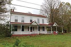 Levi Ball House |
July 2, 1984 (#84003075) |
NY 38 42°19′31″N 76°10′56″W |
Berkshire | |
| 5 | Stephen Ball House | July 2, 1984 (#84003077) |
Main St. 42°18′04″N 76°11′15″W |
Berkshire | ||
| 6 | James C. Beecher House | 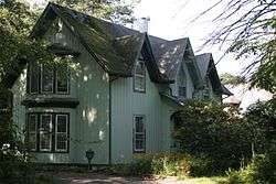 James C. Beecher House |
July 27, 2012 (#12000482) |
560 5th Ave. 42°06′16″N 76°14′46″W |
Owego | |
| 7 | Belcher Family Homestead and Farm | 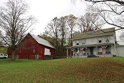 Belcher Family Homestead and Farm |
July 2, 1984 (#84003082) |
NY 38 42°17′02″N 76°11′18″W |
Berkshire | |
| 8 | Belcher-Holden Farm |  Belcher-Holden Farm |
December 15, 1997 (#97001486) |
5825 NY 38 42°11′28″N 76°12′17″W |
Newark Valley | |
| 9 | Bement-Billings House |  Bement-Billings House |
February 19, 1990 (#90000002) |
NY 38, N of Newark Valley 42°14′10″N 76°10′45″W |
Newark Valley | |
| 10 | Berkshire Village Historic District | 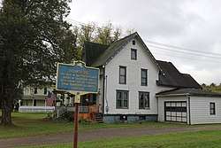 Berkshire Village Historic District |
July 2, 1984 (#84003086) |
Main St. and Leonard Ave. 42°18′22″N 76°11′14″W |
Berkshire | |
| 11 | Blewer Farm | 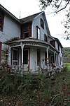 Blewer Farm |
March 16, 1998 (#98000166) |
184 and 226 Blewer-Mead Rd. 42°11′50″N 76°13′50″W |
Newark Valley | |
| 12 | Calvin A. Buffington House | July 2, 1984 (#84003089) |
Depot St. and Railroad Ave. 42°18′15″N 76°11′05″W |
Berkshire | ||
| 13 | Daniel Chamberlain House | 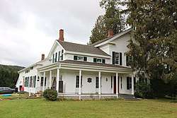 Daniel Chamberlain House |
December 15, 1997 (#97001489) |
627 Brown Rd. 42°16′22″N 76°10′28″W |
Newark Valley | |
| 14 | Morris Clinton House | 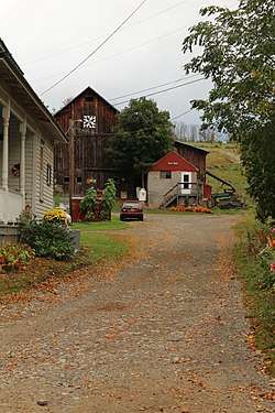 Morris Clinton House |
March 16, 1998 (#98000162) |
225 Zimmer Rd. 42°12′41″N 76°10′49″W |
Newark Valley | |
| 15 | Nathaniel Bishop Collins House | July 2, 1984 (#84003096) |
NY 38 42°18′40″N 76°11′04″W |
Berkshire | ||
| 16 | East Berkshire United Methodist Church | July 2, 1984 (#84003098) |
E. Berkshire Rd. 42°18′24″N 76°08′42″W |
Berkshire | ||
| 17 | Evergreen Cemetery | 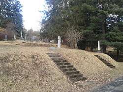 Evergreen Cemetery |
April 1, 2002 (#02000305) |
East Ave., bet. Erie St. and Prospect St. 42°06′26″N 76°15′55″W |
Owego | |
| 18 | Farrand-Pierson House | 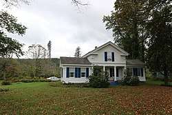 Farrand-Pierson House |
December 15, 1997 (#97001490) |
441 Brown Rd. 42°16′10″N 76°10′27″W |
Newark Valley | |
| 19 | First Congregational Church | 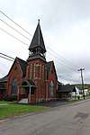 First Congregational Church |
July 2, 1984 (#84003101) |
Main St. 42°18′06″N 76°11′18″W |
Berkshire | |
| 20 | First Methodist Episcopal Church of Tioga Center |  First Methodist Episcopal Church of Tioga Center |
April 1, 2002 (#02000304) |
NY 17C 42°05′02″N 76°20′53″W |
Tioga Center | |
| 21 | First Presbyterian Church | 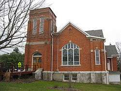 First Presbyterian Church |
December 7, 2005 (#05001392) |
75-77 N. Main St. 42°12′50″N 76°29′33″W |
Spencer | |
| 22 | Lebbeus Ford House | July 2, 1984 (#84003104) |
Jewett Hill Rd. 42°18′40″N 76°11′37″W |
Berkshire | ||
| 23 | Glenwood Cemetery and Mausoleum | March 8, 2016 (#16000064) |
113 Moore St. 42°00′29″N 76°33′03″W |
Waverly | Large 1895 hillside cemetery with 1923 marble mausoleum | |
| 24 | Grace Episcopal Church | August 2, 2000 (#00000878) |
445 Park Ave. 42°00′13″N 76°32′22″W |
Waverly | ||
| 25 | Halsey Valley Grand Army of the Republic Meeting Hall | 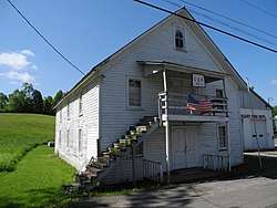 Halsey Valley Grand Army of the Republic Meeting Hall |
January 23, 2003 (#02001646) |
Hamilton Valley Rd. 42°08′27″N 76°26′28″W |
Spencer | |
| 26 | Hiawatha Farm |  Hiawatha Farm |
May 20, 1998 (#98000551) |
2293 NY 17C 42°05′30″N 76°12′46″W |
Owego | |
| 27 | Hope Cemetery and Mausoleum | 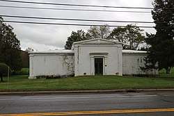 Hope Cemetery and Mausoleum |
March 16, 1998 (#98000164) |
Main St., at the town limits 42°12′39″N 76°11′25″W |
Newark Valley | |
| 28 | Knapp House | 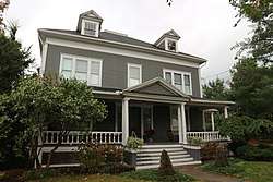 Knapp House |
March 16, 1998 (#98000159) |
10 Rock St. 42°13′24″N 76°11′00″W |
Newark Valley | |
| 29 | Lipe Farm | 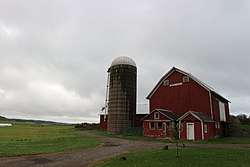 Lipe Farm |
March 16, 1998 (#98000160) |
3462 Sherry Lipe Rd. 42°11′56″N 76°09′56″W |
Newark Valley | |
| 30 | Maple Lawn Farm | 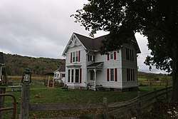 Maple Lawn Farm |
December 15, 1997 (#97001487) |
10981 NY 38 42°15′39″N 76°11′00″W |
Newark Valley | |
| 31 | John W. McCarty House | 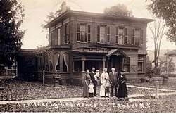 John W. McCarty House |
March 12, 2001 (#01000249) |
118 Main St. 42°13′52″N 76°20′27″W |
Candor | |
| 32 | Newark Valley Municipal Building and Tappan-Spaulding Memorial Library | 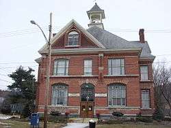 Newark Valley Municipal Building and Tappan-Spaulding Memorial Library |
November 1, 2006 (#06000971) |
9 Park St. and 8 Rock St. 42°13′25″N 76°11′02″W |
Newark Valley | |
| 33 | Nichols High School | 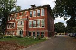 Nichols High School |
May 16, 1996 (#96000553) |
84 Cady Ave. 42°01′14″N 76°21′54″W |
Nichols | |
| 34 | Nowland House | 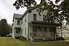 Nowland House |
December 15, 1997 (#97001488) |
88 S. Main St. 42°13′10″N 76°11′14″W |
Newark Valley | |
| 35 | Owego Central Historic District | 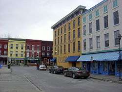 Owego Central Historic District |
December 3, 1980 ((original) 98000353 (increase) #80002780 (original) 98000353 (increase)) |
North Ave., Park, Main, Lake, Court, and Fronts Sts. 42°06′06″N 76°15′40″W |
Owego | |
| 36 | Platt-Cady Mansion | 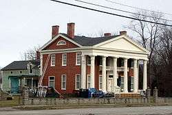 Platt-Cady Mansion |
August 13, 1976 (#76001286) |
18 River St. 42°01′19″N 76°22′00″W |
Nichols | |
| 37 | Gilbert E. Purple House | 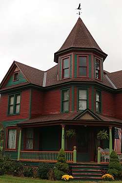 Gilbert E. Purple House |
September 15, 2004 (#04000992) |
34 Maple Ave. 42°13′36″N 76°11′20″W |
Newark Valley | |
| 38 | Riverside Cemetery | January 15, 2014 (#13001093) |
Marshland Rd. 42°05′08″N 76°09′34″W |
Apalachin vicinity | Final resting place of many early settlers of region | |
| 39 | Deodatus Royce House | July 2, 1984 (#84003109) |
NY 38 42°19′26″N 76°11′02″W |
Berkshire | ||
| 40 | J. B. Royce House and Farm Complex | July 2, 1984 (#84003111) |
NY 38 42°19′42″N 76°10′46″W |
Berkshire | ||
| 41 | St. Paul's Church | 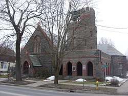 St. Paul's Church |
October 16, 1997 (#97001204) |
117 Main St. 42°06′09″N 76°15′55″W |
Owego | |
| 42 | John Settle Farm | 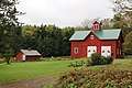 John Settle Farm |
March 16, 1998 (#98000161) |
1054 Settle Rd. 42°12′31″N 76°07′44″W |
Newark Valley | |
| 43 | Silk Street Bridge | 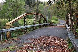 Silk Street Bridge |
April 30, 1998 (#98000430) |
Silk St., over E Branch of Owego Cr. 42°13′03″N 76°11′38″W |
Newark Valley | |
| 44 | Sutton-Chapman-Howland House | 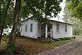 Sutton-Chapman-Howland House |
December 15, 1997 (#97001492) |
55 Main St. 42°16′22″N 76°10′28″W |
Newark Valley | |
| 45 | Tioga Centre General Store | 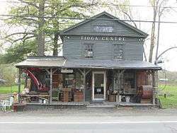 Tioga Centre General Store |
January 15, 2003 (#02001709) |
3019 NY 17C 42°03′25″N 76°20′53″W |
Tioga Center | |
| 46 | Tioga County Courthouse | 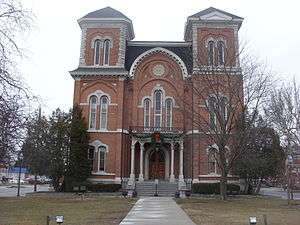 Tioga County Courthouse |
December 26, 1972 (#72000915) |
Village Park 42°06′09″N 76°15′45″W |
Owego | |
| 47 | US Post Office-Owego |  US Post Office-Owego |
May 11, 1989 (#88002391) |
6 Lake St. 42°06′10″N 76°15′41″W |
Owego | |
| 48 | US Post Office-Waverly |  US Post Office-Waverly |
May 11, 1989 (#88002444) |
434-348 Waverly St. 42°00′07″N 76°32′26″W |
Waverly | |
| 49 | Vesper Cliff | 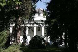 Vesper Cliff |
July 29, 2005 (#05000746) |
Outside Village of Owego, W bank of Owego Creek, off NY 17 42°05′54″N 76°16′45″W |
Owego | |
| 50 | Wade Farm | 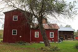 Wade Farm |
December 15, 1997 (#97001491) |
5579 NY 38 42°11′17″N 76°12′34″W |
Newark Valley | |
| 51 | Waits Methodist Episcopal Church and Cemetery | 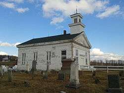 Waits Methodist Episcopal Church and Cemetery |
November 20, 2000 (#00001290) |
Waite Rd. 42°00′27″N 76°16′08″W |
Owego | |
| 52 | Waverly Junior and Senior High School | November 7, 1997 (#97001389) |
443 Pennsylvania Ave. 42°00′14″N 76°32′18″W |
Waverly | ||
| 53 | Waverly Village Hall |  Waverly Village Hall |
July 5, 2003 (#03000600) |
358-360 Broad St. 42°00′03″N 76°32′22″W |
Waverly | |
| 54 | West Newark Congregational Church and Cemetery | 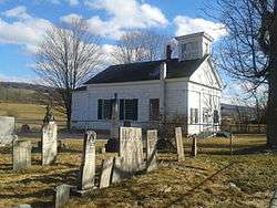 West Newark Congregational Church and Cemetery |
March 16, 1998 (#98000165) |
Jct. of W. Creek Rd. and W. Newark Cross Rd. 42°14′32″N 76°14′09″W |
Newark Valley | |
| 55 | West Newark School House | March 16, 1998 (#98000163) |
Jct. of W. Creek Rd. and W. Newark Cross Rd. 42°14′30″N 76°14′12″W |
Newark Valley |
See also
| Wikimedia Commons has media related to National Register of Historic Places in Tioga County, New York. |
References
- The latitude and longitude information provided in this table was derived originally from the National Register Information System, which has been found to be fairly accurate for about 99% of listings. Some locations in this table may have been corrected to current GPS standards.
- "National Register of Historic Places: Weekly List Actions". National Park Service, United States Department of the Interior. Retrieved on June 19, 2020.
- Numbers represent an ordering by significant words. Various colorings, defined here, differentiate National Historic Landmarks and historic districts from other NRHP buildings, structures, sites or objects.
- The eight-digit number below each date is the number assigned to each location in the National Register Information System database, which can be viewed by clicking the number.
| Topics |  | |
|---|---|---|
| Lists by county |
| |
| Lists by city | ||
| Other lists | ||
| ||
This article is issued from Wikipedia. The text is licensed under Creative Commons - Attribution - Sharealike. Additional terms may apply for the media files.