National Register of Historic Places listings in Chenango County, New York
List of the National Register of Historic Places listings in Chenango County, New York
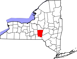
Location of Chenango County in New York
This is intended to be a complete list of properties and districts listed on the National Register of Historic Places in Chenango County, New York. The locations of National Register properties and districts for which the latitude and longitude coordinates are included below, may be seen in a map.[1]
- This National Park Service list is complete through NPS recent listings posted June 26, 2020.[2]
| Albany (Albany) – Allegany – Bronx – Broome – Cattaraugus – Cayuga – Chautauqua – Chemung – Chenango – Clinton – Columbia – Cortland – Delaware – Dutchess (Poughkeepsie, Rhinebeck) – Erie (Buffalo) – Essex – Franklin – Fulton – Genesee – Greene – Hamilton – Herkimer – Jefferson – Kings – Lewis – Livingston – Madison – Monroe (Rochester) – Montgomery – Nassau – New York (Below 14th Street, 14th to 59th Streets, 59th to 110th Streets, Above 110th Street, Islands) – Niagara – Oneida – Onondaga – Ontario – Orange – Orleans – Oswego – Otsego – Putnam – Queens – Rensselaer – Richmond – Rockland – St. Lawrence – Saratoga – Schenectady – Schoharie – Schuyler – Seneca – Steuben – Suffolk – Sullivan – Tioga – Tompkins – Ulster – Warren – Washington – Wayne – Westchester (Northern, Southern, New Rochelle, Peekskill, Yonkers) – Wyoming – Yates |
Current listings
| [3] | Name on the Register | Image | Date listed[4] | Location | City or town | Description |
|---|---|---|---|---|---|---|
| 1 | Bainbridge Historic District | 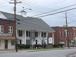 Bainbridge Historic District |
November 9, 1982 (#82001095) |
E. Main, Juliand, N. Main, Pearl, S. Main, and W. Main Sts., Park Pl. and Railroad Ave. 42°17′41″N 75°28′46″W |
Bainbridge | |
| 2 | Bates Round Barn | 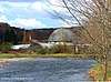 Bates Round Barn |
September 29, 1984 (#84002071) |
NY 12 42°18′10″N 75°48′07″W |
Greene | |
| 3 | Theodore Burr House |  Theodore Burr House |
September 11, 1981 (#81000402) |
Fort Hill Sq. 42°26′27″N 75°35′48″W |
Oxford | |
| 4 | Calvary Episcopal Church | February 20, 1998 (#98000130) |
North St., W of Moon Hill Rd. 42°29′58″N 75°46′05″W |
McDonough | ||
| 5 | Chenango County Courthouse District |  Chenango County Courthouse District |
June 10, 1975 (#75001178) |
Irregular pattern between Hayes and Mechanic Sts. and Maple Ave. and City Hall 42°31′53″N 75°31′27″W |
Norwich | |
| 6 | Clinton-Rosekrans Law Building |  Clinton-Rosekrans Law Building |
July 27, 1979 (#79001569) |
62 Genesee St 42°19′47″N 75°46′15″W |
Greene | |
| 7 | Columbus Community Church |  Columbus Community Church |
March 20, 1986 (#86000487) |
NY 80 42°41′01″N 75°22′24″W |
Columbus | |
| 8 | District School 2 | February 25, 2004 (#04000096) |
Cty Rte 27 42°18′53″N 75°35′54″W |
Coventryville | ||
| 9 | District School 4 | April 21, 2004 (#04000353) |
NY 235 42°18′53″N 75°38′22″W |
Coventry | ||
| 10 | Earlville Historic District | 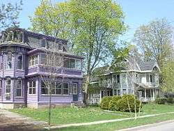 Earlville Historic District |
October 29, 1982 (#82001096) |
Fayette and N., S., E., and W. Main Sts. 42°44′25″N 75°32′42″W |
Earlville | |
| 11 | Eaton Family Residence-Jewish Center of Norwich | 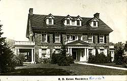 Eaton Family Residence-Jewish Center of Norwich |
June 4, 2009 (#09000375) |
72 S. Broad St. 42°31′38″N 75°31′24″W |
Norwich | |
| 12 | Earlville Opera House | 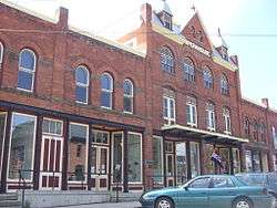 Earlville Opera House |
January 22, 1973 (#73001169) |
12-20 E. Main St. 42°44′22″N 75°32′41″W |
Earlville | |
| 13 | Emmanuel Episcopal Church Complex | 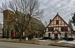 Emmanuel Episcopal Church Complex |
August 26, 2009 (#09000654) |
37 W. Main St. 42°31′50″N 75°31′38″W |
Norwich | 1874 Gothic Revival church by Isaac G. Perry, with 1915 parish house |
| 14 | Greene Historic District | 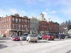 Greene Historic District |
September 9, 1982 (#82003350) |
Chenango, Genesee, and Jackson Sts. 42°19′44″N 75°46′18″W |
Greene | |
| 15 | Guilford Center Presbyterian Church | 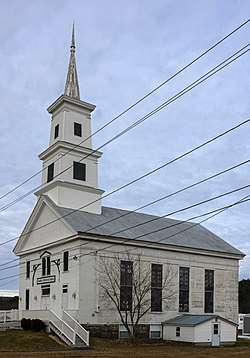 Guilford Center Presbyterian Church |
September 24, 2004 (#04001059) |
Cty Rd. 36 42°24′23″N 75°27′53″W |
Guilford Center | 1817 church now home to local historic society |
| 16 | Guilford Center Cemetery | 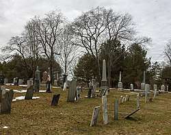 Guilford Center Cemetery |
October 5, 2005 (#05001129) |
Cty Rte. 36 42°24′29″N 75°27′57″W |
Guilford Center | Deceased buried here include many of Guilford's early settlers, including some Revolutionary War veterans, going back to 1809. |
| 17 | Charles C. Hovey House and Strong Leather Company Mill | December 6, 1996 (#96001426) |
53 W. Main St. and 10 Bixby St. 42°17′45″N 75°29′00″W |
Bainbridge | ||
| 18 | Jewell Family Homestead | 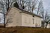 Jewell Family Homestead |
January 31, 2017 (#100000611) |
120 Furnace Hill Rd. 42°24′29″N 75°29′34″W |
Guilford | 1824 house built by New Hampshire family is well-preserved example of New England-style center-hall plan structure from that era. |
| 19 | Loomis Family Farm |  Loomis Family Farm |
June 13, 2014 (#14000329) |
414 S. Tyner Rd. 42°25′27″N 75°39′58″W |
Oxford | |
| 20 | Main Street Historic District |  Main Street Historic District |
June 30, 1983 (#83001662) |
169-191 and 158-180 Main St. 42°13′41″N 75°31′36″W |
Afton | |
| 21 | Holden B. Mathewson House | 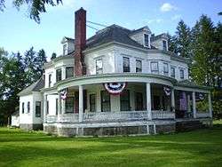 Holden B. Mathewson House |
October 23, 2009 (#09000860) |
1567 NY 26 42°13′41″N 75°31′36″W |
South Otselic | |
| 22 | Methodist-Episcopal Church of Norwich | 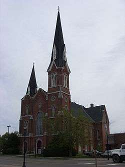 Methodist-Episcopal Church of Norwich |
August 28, 2003 (#03000846) |
74 N. Broad St. 42°32′01″N 75°31′26″W |
Norwich | |
| 23 | Horace O. Moss House | 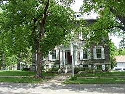 Horace O. Moss House |
May 17, 1974 (#74001224) |
45 S. Main St. 42°37′16″N 75°19′55″W |
New Berlin | |
| 24 | New Berlin Historic District | 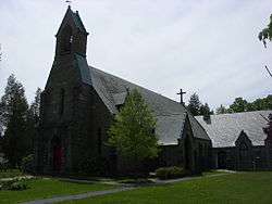 New Berlin Historic District |
August 12, 1982 (#82005025) |
Roughly along Main, West and Genesee Sts. 42°37′21″N 75°19′56″W |
New Berlin | |
| 25 | Newton Homestead | June 3, 1982 (#82003351) |
Ridge Rd. 42°39′04″N 75°47′08″W |
South Otselic | Octagon house built in 1860 | |
| 26 | North Broad Street Historic District | 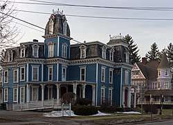 North Broad Street Historic District |
November 21, 1978 (#78001845) |
Broad St. 42°32′14″N 75°31′30″W |
Norwich | Three-block area of late 19th- and early 20th-century homes built by city's elite |
| 27 | North Guilford Cemetery | January 24, 2020 (#100004911) |
158 Whites Hill Rd. 42°27′10″N 75°28′34″W |
North Guilford | ||
| 28 | Norwich Pharmacal Company Warehouse |  Norwich Pharmacal Company Warehouse |
November 16, 2018 (#100003111) |
20 American Ave. 42°31′50″N 75°31′18″W |
Norwich | 1916 warehouse known locally as the Unguentine Building, for the ghost sign promoting the surgical antiseptic what is now Norwich Pharma Services introduced in 1893 |
| 29 | Oxford Village Historic District |  Oxford Village Historic District |
September 17, 1985 (#85002481) |
Roughly Washington Ave., State St., Chenango River, Merchant & Green Sts., Washington Park, Albany & Pleasant Sts. 42°26′27″N 75°35′40″W |
Oxford | |
| 30 | Phillips–Manning House | March 13, 2017 (#100000754) |
154 Nursery St. 42°19′03″N 75°38′17″W |
Coventry | 1840s Greek Revival house of two prominent families in town | |
| 31 | Rockdale Community Church | 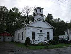 Rockdale Community Church |
October 5, 2005 (#05001128) |
NY 8 42°22′39″N 75°24′30″W |
Rockdale | |
| 32 | Rockwells Mills Historic District | August 30, 2010 (#10000610) |
NY 8 and Crandall Road 42°26′56″N 75°23′24″W |
Guilford | ||
| 33 | Sannick Family Farm | April 18, 2007 (#07000335) |
129 Jordan Ln. 42°23′27″N 75°36′59″W |
South Oxford | ||
| 34 | Sherburne High School | November 3, 1988 (#88002185) |
16 Chapel St. 42°40′33″N 75°29′39″W |
Sherburne | ||
| 35 | Sherburne Historic District | 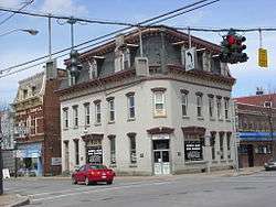 Sherburne Historic District |
October 29, 1982 (#82001097) |
N. and S. Main, E. and W. State, Classic, Summit and Church Sts. and Park Ave. 42°40′37″N 75°29′38″W |
Sherburne | |
| 36 | Smithville Valley Grange No. 1397 | 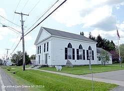 Smithville Valley Grange No. 1397 |
August 6, 1998 (#98001009) |
NY 41 42°23′57″N 75°48′33″W |
Smithville Flats | |
| 37 | Smyrna Elementary School | December 16, 1996 (#96001428) |
School St., SE of NY 80 42°41′10″N 75°34′12″W |
Smyrna | ||
| 38 | Smyrna Town Hall-Opera House | July 25, 2008 (#08000699) |
Academy Street 42°41′14″N 75°34′14″W |
Smyrna | ||
| 39 | South Otselic Historic District | 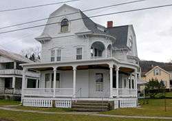 South Otselic Historic District |
September 8, 1983 (#83001663) |
Gladding, N. and S. Main Sts., Clarence Church and Plank Rds., and Potter Ave. 42°38′48″N 75°46′52″W |
South Otselic | |
| 40 | Upperville Meeting House | 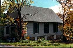 Upperville Meeting House |
April 1, 2002 (#02000307) |
NY 80 42°42′00″N 75°36′58″W |
Upperville | |
| 41 | US Post Office-Norwich | 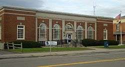 US Post Office-Norwich |
May 11, 1989 (#88002380) |
20-22 E. Main St. 42°31′51″N 75°31′20″W |
Norwich | 1932 building with elaborate classically-detailed stonework |
| 42 | US Post Office-Oxford | 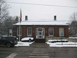 US Post Office-Oxford |
May 11, 1989 (#88002392) |
2 S. Washington Ave.[5] 42°26′32″N 75°35′56″W |
Oxford | |
| 43 | West Hill Cemetery | 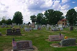 West Hill Cemetery |
January 18, 2006 (#05001534) |
NY 80 42°41′39″N 75°31′56″W |
Sherburne | |
| 44 | White Store Church and Evergreen Cemetery | February 10, 1995 (#95000047) |
Jct. of NY 8 and White Store Rd., 4 mi. S of South New Berlin 42°29′01″N 75°24′23″W |
Norwich | ||
| 45 | Hazard Willcox Jr. Farm | April 12, 2019 (#100003626) |
549 Co. Rd. 14 42°43′26″N 75°33′19″W |
Earlville | ||
| 46 | Young Round Barn | 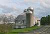 Young Round Barn |
September 29, 1984 (#84002072) |
NY 12 42°17′39″N 75°48′28″W |
Greene |
See also
| Wikimedia Commons has media related to National Register of Historic Places in Chenango County, New York. |
References
- The latitude and longitude information provided is primarily from the National Register Information System, and has been found to be fairly accurate for about 99% of listings. For 1%, the location info may be way off. We seek to correct the coordinate information wherever it is found to be erroneous. Please leave a note in the Discussion page for this article if you believe any specific location is incorrect.
- "National Register of Historic Places: Weekly List Actions". National Park Service, United States Department of the Interior. Retrieved on June 26, 2020.
- Numbers represent an ordering by significant words. Various colorings, defined here, differentiate National Historic Landmarks and historic districts from other NRHP buildings, structures, sites or objects.
- The eight-digit number below each date is the number assigned to each location in the National Register Information System database, which can be viewed by clicking the number.
- Address based on USPS website. Accessed March 29, 2016.
External links
A useful list of the above sites, with street addresses and other information, is available at Chenango County, New York, listing, at National Register of Historic Places.Com, a private site serving up public domain information on NRHPs.
| Topics |  | |
|---|---|---|
| Lists by county |
| |
| Lists by city | ||
| Other lists | ||
| ||
This article is issued from Wikipedia. The text is licensed under Creative Commons - Attribution - Sharealike. Additional terms may apply for the media files.