National Register of Historic Places listings in Sullivan County, New York
List of the National Register of Historic Places listings in Sullivan County, New York
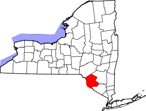
Location of Sullivan County in New York
This is intended to be a complete list of properties and districts listed on the National Register of Historic Places in Sullivan County, New York. The locations of National Register properties and districts showing latitude and longitude coordinates may be seen in a map by clicking on "Map of all coordinates".[1] The Delaware and Hudson Canal, which runs through this and other counties, is further designated a U.S. National Historic Landmark.
- This National Park Service list is complete through NPS recent listings posted June 19, 2020.[2]
| Albany (Albany) – Allegany – Bronx – Broome – Cattaraugus – Cayuga – Chautauqua – Chemung – Chenango – Clinton – Columbia – Cortland – Delaware – Dutchess (Poughkeepsie, Rhinebeck) – Erie (Buffalo) – Essex – Franklin – Fulton – Genesee – Greene – Hamilton – Herkimer – Jefferson – Kings – Lewis – Livingston – Madison – Monroe (Rochester) – Montgomery – Nassau – New York (Below 14th Street, 14th to 59th Streets, 59th to 110th Streets, Above 110th Street, Islands) – Niagara – Oneida – Onondaga – Ontario – Orange – Orleans – Oswego – Otsego – Putnam – Queens – Rensselaer – Richmond – Rockland – St. Lawrence – Saratoga – Schenectady – Schoharie – Schuyler – Seneca – Steuben – Suffolk – Sullivan – Tioga – Tompkins – Ulster – Warren – Washington – Wayne – Westchester (Northern, Southern, New Rochelle, Peekskill, Yonkers) – Wyoming – Yates |
Listings county-wide
| [3] | Name on the Register | Image | Date listed[4] | Location | City or town | Description |
|---|---|---|---|---|---|---|
| 1 | Anshei Glen Wild Synagogue | 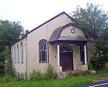 Anshei Glen Wild Synagogue |
January 15, 1999 (#98001618) |
Glen Wild Road 41°39′00″N 74°35′20″W |
Glen Wild | 1923 synagogue built and still owned by local family. Has never had its own rabbi. |
| 2 | Agudas Achim Synagogue |  Agudas Achim Synagogue |
November 19, 1998 (#98001404) |
Rock Ave. 41°54′03″N 74°49′28″W |
Livingston Manor | 1924 synagogue built at unusual angle, shows influence of local churches with lancet arch windows |
| 3 | Arlington Hotel | 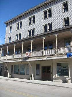 Arlington Hotel |
March 31, 1983 (#83001806) |
Main St. 41°36′30″N 75°03′40″W |
Narrowsburg | |
| 4 | B'nai Israel Synagogue |  B'nai Israel Synagogue |
January 15, 1999 (#98001620) |
NY 52 41°45′29″N 74°36′08″W |
Woodbourne | |
| 5 | Beaverkill Covered Bridge | 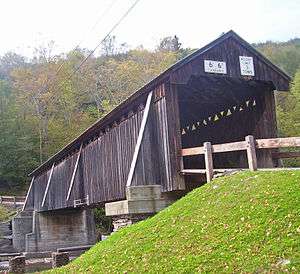 Beaverkill Covered Bridge |
October 3, 2007 (#07001038) |
CR 30 over Beaverkill Cr. 41°58′53″N 74°50′12″W |
Beaverkill | 1865 covered bridge was one of earliest crossings of river in remote, unsettled area of Catskills. Some uncertainty as to who actually built it. Unusual variant on Ithiel Town-patented design. |
| 6 | Bennett Family House | 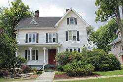 Bennett Family House |
December 28, 2001 (#01001400) |
11 Hamilton Ave. 41°39′20″N 74°40′58″W |
Monticello | |
| 7 | Bikur Cholim B'nai Israel Synagogue |  Bikur Cholim B'nai Israel Synagogue |
January 15, 1999 (#98001619) |
Old White Lake Turnpike at NY 55 41°42′54″N 74°47′59″W |
Swan Lake | |
| 8 | Bloomingburg Reformed Protestant Dutch Church |  Bloomingburg Reformed Protestant Dutch Church |
January 10, 1980 (#80002779) |
NY 17M 41°33′21″N 74°26′34″W |
Bloomingburg | 1821 church is local landmark and one of the oldest churches in the county. Currently being prepared for use as a historical museum. |
| 9 | Broadway Historic District |  Broadway Historic District |
January 30, 2020 (#100004915) |
Broadway, Liberty, Bank, North, Jones, Pleasant & St. John Sts. and Landfield Ave. 41°39′19″N 74°41′19″W |
Monticello | HIstoric core of county seat |
| 10 | C. Burton Hotel |  C. Burton Hotel |
March 16, 2005 (#05000171) |
450 Main St. 41°51′11″N 74°33′09″W |
Grahamsville | 1851 hotel is possibly the only surviving Greek Revival building in county with columns and a ballroom. |
| 11 | Ellery Calkins House |  Ellery Calkins House |
November 27, 1992 (#92001595) |
Co. Rd. 114, E of Delaware R. Bridge 41°42′27″N 75°03′50″W |
Cochecton | |
| 12 | Callicoon Downtown Historic District | 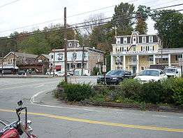 Callicoon Downtown Historic District |
June 21, 2016 (#16000390) |
Main Sts, Highview & Mitchell Aves., River & Hospital Rds., Bridge St., and NY 97 41°45′59″N 75°03′26″W |
Callicoon | Core of riverside community that grew up around 1848 railroad station |
| 13 | Callicoon Methodist Church and Parsonage | 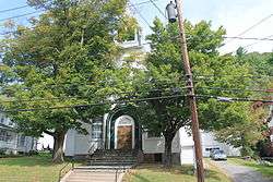 Callicoon Methodist Church and Parsonage |
November 4, 1993 (#93001134) |
Church St. (NY 97) S of jct. with Seminary Rd., Town of Delaware 41°46′00″N 75°03′20″W |
Callicoon | |
| 14 | Callicoon National Bank | 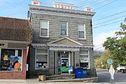 Callicoon National Bank |
February 18, 1994 (#94000048) |
133 Main St. 41°45′58″N 75°03′32″W |
Callicoon | |
| 15 | Center Theatre | 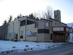 Center Theatre |
February 23, 2001 (#01000170) |
NY 52 41°45′30″N 74°36′08″W |
Woodbourne | |
| 16 | Chevro Ahavath Zion Synagogue | January 28, 1999 (#98001621) |
Cold Spring Rd. 41°36′42″N 74°40′38″W |
Monticello | ||
| 17 | Cochecton Center Methodist Episcopal Church | 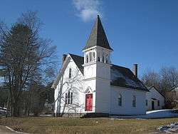 Cochecton Center Methodist Episcopal Church |
April 21, 2000 (#00000343) |
Skipperdine Rd. 41°39′21″N 74°59′05″W |
Cochecton Center | |
| 18 | Cochecton Presbyterian Church | 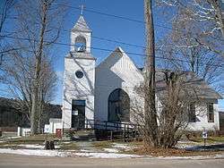 Cochecton Presbyterian Church |
November 27, 1992 (#92001597) |
Co. Rd. 114, E of Delaware R. Bridge 41°42′25″N 75°03′52″W |
Cochecton | |
| 19 | Cochecton Railroad Station | 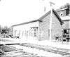 Cochecton Railroad Station |
March 16, 2005 (#05000172) |
NY 97 41°43′04″N 75°02′46″W |
Cochecton | |
| 20 | Delaware and Hudson Canal | 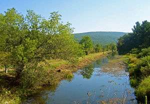 Delaware and Hudson Canal |
November 24, 1968 (#68000051) |
Delaware and Hudson Canal Coordinates missing |
Minisink | |
| 21 | Delaware Aqueduct | 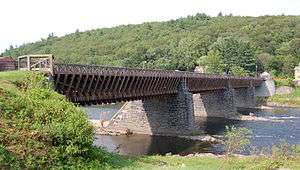 Delaware Aqueduct |
November 24, 1968 (#68000055) |
Between Minisink Ford, NY and Lackawaxen, PA 41°28′57″N 74°58′37″W |
Minisink Ford | Oldest wire suspension bridge in the U.S.; design precedent for Brooklyn Bridge; extends into Pike County, Pennsylvania |
| 22 | Drake-Curtis House |  Drake-Curtis House |
April 19, 1993 (#92001598) |
Co. Rd. 114, E of NY 97 41°42′32″N 75°03′06″W |
Cochecton | |
| 23 | Dundas Castle | 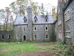 Dundas Castle |
March 21, 2001 (#01000245) |
Berry Brook Rd. 41°58′46″N 74°52′38″W |
Roscoe | (be sure to link in article to Dundas Castle in Edinburgh, Scotland) |
| 24 | Ferndale School | 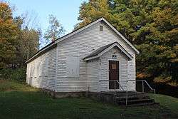 Ferndale School |
January 5, 2005 (#04001437) |
Upper Ferndale Rd. and Ferndale Loomis Rd. 41°46′36″N 74°44′29″W |
Ferndale | |
| 25 | First Methodist Episcopal Church of Parksville | 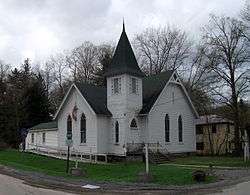 First Methodist Episcopal Church of Parksville |
May 30, 2001 (#01000575) |
10 Short Ave. 41°51′21″N 74°45′32″W |
Parksville | |
| 26 | Forestburgh Town Hall | _Town_Hall%2C_1929.jpg) Forestburgh Town Hall |
May 11, 2011 (#11000278) |
305 County Road 48 41°32′28″N 74°43′30″W |
Forestburgh vicinity | New listing; refnum 11000278 |
| 27 | German Presbyterian Church and Hortonville Cemetery | 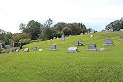 German Presbyterian Church and Hortonville Cemetery |
January 15, 2003 (#02001712) |
CR 121 and CR 131 41°46′21″N 75°01′42″W |
Hortonville | |
| 28 | Glen Wild Methodist Church | 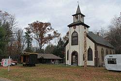 Glen Wild Methodist Church |
May 10, 1984 (#84003035) |
Old Glen Wild Rd. 41°39′58″N 74°35′18″W |
Glen Wild | |
| 29 | Grahamsville Historic District | 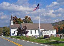 Grahamsville Historic District |
December 6, 1979 (#79001634) |
NY 55 41°50′48″N 74°32′19″W |
Grahamsville | Intact core of 19th-century Grahamsville, east of present hamlet's downtown, with buildings mostly intact |
| 30 | Greenfield Preparative Meeting House | November 29, 2010 (#10000956) |
NY 55 at Denman Mountain Road 41°51′16″N 74°33′16″W |
Grahamsville | New listing; refnum 10000956 | |
| 31 | Hankins District No. One Schoolhouse | February 4, 2000 (#00000054) |
Sullivan Cty Rd. 132 41°48′59″N 75°04′58″W |
Hankins | ||
| 32 | Hankins Stone Arch Bridge | 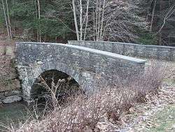 Hankins Stone Arch Bridge |
July 27, 2000 (#00000838) |
Sullivean Cty. Rd. 94, E. 41°48′59″N 75°05′31″W |
Hankins | |
| 33 | Hart House | January 18, 2006 (#05001535) |
50 Hamilton St. 41°35′14″N 74°22′50″W |
Burlingham | ||
| 34 | Hasbrouck House | September 13, 2019 (#100004419) |
282 Hasbrouck Road 41°47′33″N 74°37′02″W |
Woodbourne | 1810 stone house built by early settler now used as art center | |
| 35 | Hebrew Congregation of Mountaindale Synagogue | 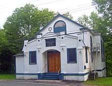 Hebrew Congregation of Mountaindale Synagogue |
May 30, 2001 (#01000578) |
NY 55 41°41′18″N 74°31′51″W |
Mountaindale | 1917 synagogue is only one in county with its own mikvah |
| 36 | Hessinger Store | June 2, 2000 (#00000584) |
Main St. (Co. Rd. 122) 41°50′10″N 74°56′51″W |
Callicoon Center | Demolished 2011[5] | |
| 37 | Jeffersonville School | 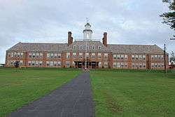 Jeffersonville School |
April 28, 1988 (#88000519) |
Terrace Ave. 41°46′48″N 74°56′25″W |
Jeffersonville | |
| 38 | Jewish Center of Lake Huntington | 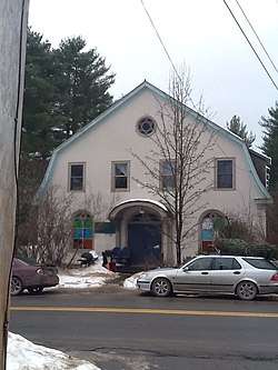 Jewish Center of Lake Huntington |
December 11, 2009 (#09001087) |
13 County Road 116 41°46′48″N 74°56′25″W |
Lake Huntington | New listing; refnum 09001087 |
| 39 | Jewish Community Center of White Sulphur Springs | 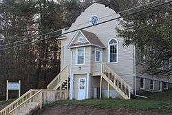 Jewish Community Center of White Sulphur Springs |
August 12, 1999 (#99000991) |
Briscoe Rd. 41°47′56″N 74°49′52″W |
White Sulphur Springs | |
| 40 | Kirk House | May 10, 1984 (#84003043) |
Kirk's Rd. 41°36′27″N 75°03′26″W |
Narrowsburg | ||
| 41 | Levitz Family Farm | January 24, 2002 (#01001497) |
395 Beaver Dam Rd. 41°47′51″N 74°32′00″W |
Grahamsville | ||
| 42 | Liberty Downtown Historic District | 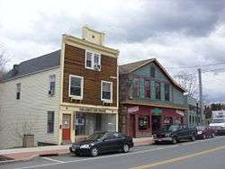 Liberty Downtown Historic District |
May 26, 2006 (#06000266) |
Main, Chestnut, Academy, School, Church, Maple, John, Edgar Sts., and Darbee Ln. 41°48′03″N 74°44′48″W |
Liberty | |
| 43 | Liberty Village Historic District |  Liberty Village Historic District |
April 11, 1978 (#78001921) |
N. Main, Academy, and Law Sts. 41°48′05″N 74°44′53″W |
Liberty | |
| 44 | Loch Sheldrake Synagogue | 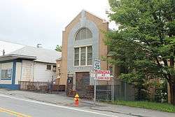 Loch Sheldrake Synagogue |
August 12, 1997 (#97000844) |
NY 52, N of jct. of NY 52 and Loch Sheldrake Rd. 41°46′15″N 74°39′29″W |
Loch Sheldrake | |
| 45 | Mamakating Park Historic District | 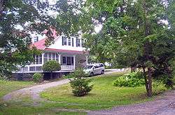 Mamakating Park Historic District |
November 19, 1998 (#98001393) |
Roughly along Park Rd, Columbian Rd., and Mamakating Ave. 41°36′45″N 74°32′12″W |
Wurtsboro | 1890s Catskill ridgetop resort community, never fully realized |
| 46 | Manion's General Store | 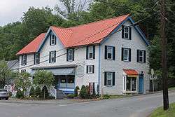 Manion's General Store |
April 15, 2004 (#04000285) |
52 Ferndale Rd. 41°46′26″N 74°44′22″W |
Ferndale | |
| 47 | Anthony Manny House | 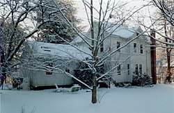 Anthony Manny House |
September 15, 2000 (#00000840) |
6 Hankins Rd. 41°48′53″N 75°05′15″W |
Hankins | |
| 48 | Masten-Quinn House |  Masten-Quinn House |
February 13, 2003 (#03000046) |
59 First St. 41°34′37″N 74°28′52″W |
Wurtsboro | 1820s house of early farmer who took advantage of D&H Canal route through his land. Farmed until mid-20th century. |
| 49 | Milanville-Skinners Falls Bridge |  Milanville-Skinners Falls Bridge |
November 14, 1988 (#88002167) |
Legislative Route 63027 over the Delaware River at Milanville 41°40′10″N 75°03′31″W |
Skinners Falls | Extends into Damascus Township in Wayne County, Pennsylvania |
| 50 | Minisink Battlefield |  Minisink Battlefield |
September 16, 1993 (#93000946) |
Minisink Battleground Road (Co. Rd. 168) N of Minisink Ford 41°29′15″N 74°58′19″W |
Minisink Ford | Location of the Battle of Minisink during the American Revolution |
| 51 | Munson Diner |  Munson Diner |
April 12, 2006 (#06000256) |
Lake St. (NY 55) 41°47′47″N 74°44′46″W |
Liberty | |
| 52 | Narrowsburg Methodist Church |  Narrowsburg Methodist Church |
February 4, 2000 (#00000053) |
Lake St. 41°36′18″N 75°03′45″W |
Narrowsburg | |
| 53 | Ohave Shalom Synagogue |  Ohave Shalom Synagogue |
November 22, 2000 (#00001412) |
Mauric Rose St. 41°42′38″N 74°34′23″W |
Woodridge | 1930 synagogue combines urban and Eastern European design traditions. Interior paintings are unique in county |
| 54 | Old Cochecton Cemetery | 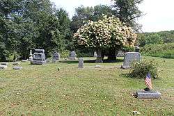 Old Cochecton Cemetery |
November 27, 1992 (#92001593) |
W of NY 97, N of jct. with Co. Rd. 114 41°42′40″N 75°02′58″W |
Cochecton | |
| 55 | Page House | November 27, 1992 (#92001601) |
59 C. Meyer Rd. 41°41′01″N 75°02′53″W |
Cochecton | ||
| 56 | Parsonage Road Historic District | 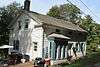 Parsonage Road Historic District |
November 27, 1992 (#92001600) |
Parsonage Rd. 41°42′31″N 75°03′40″W |
Cochecton | |
| 57 | Pond Eddy Bridge | 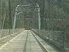 Pond Eddy Bridge |
November 14, 1988 (#88002170) |
LR 51013 over the Delaware River 41°26′21″N 74°49′13″W |
Lumberland | Extends into Pike County, Pennsylvania |
| 58 | Reilly's Store |  Reilly's Store |
November 27, 1992 (#92001594) |
Co. Rd. 114, W of jct. with NY 97 41°42′30″N 75°03′45″W |
Cochecton | |
| 59 | Rialto Theatre |  Rialto Theatre |
February 2, 2001 (#01000043) |
Broadway 41°39′20″N 74°41′17″W |
Monticello | |
| 60 | Riverside Cemetery | November 18, 1993 (#93001226) |
NY 97 SE of jct. with Church St. 41°50′50″N 75°07′36″W |
Long Eddy | ||
| 61 | Rivoli Theatre | 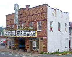 Rivoli Theatre |
January 26, 2001 (#00001691) |
Jct. of NY 42 and Laurel Ave. 41°41′56″N 74°38′15″W |
South Fallsburg | 1923 theater, renovated in Art Deco style in 1937. Preserved nearly intact and still used by local theater group |
| 62 | Rockland Mill Complex | August 23, 1984 (#84003062) |
Palen Pl. 41°56′56″N 74°54′52″W |
Rockland | ||
| 63 | Roscoe Presbyterian Church and Westfield Flats Cemetery | 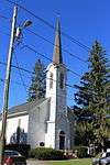 Roscoe Presbyterian Church and Westfield Flats Cemetery |
June 8, 2001 (#01000574) |
Old NY 17 41°55′56″N 74°54′47″W |
Roscoe | |
| 64 | St. James Church and Rectory | 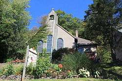 St. James Church and Rectory |
November 4, 1993 (#93001135) |
NY 17B N side, E of jct. with NY 97, Town of Delaware 41°45′54″N 75°03′11″W |
Callicoon | |
| 65 | St. John's Episcopal Church and Rectory |  St. John's Episcopal Church and Rectory |
November 21, 2002 (#02001359) |
15 St. John's St. 41°39′12″N 74°41′12″W |
Monticello | |
| 66 | St. Joseph's Seminary | 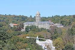 St. Joseph's Seminary |
July 8, 1993 (#93000582) |
Seminary Rd. W side 41°46′12″N 75°03′29″W |
Callicoon | |
| 67 | St. Paul's Evangelical Lutheran Church | 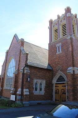 St. Paul's Evangelical Lutheran Church |
August 15, 1997 (#97000845) |
24 Chestnut St. 41°47′56″N 74°44′50″W |
Liberty | |
| 68 | Shelburne Playhouse | April 15, 2004 (#04000284) |
Upper Ferndale Rd. 41°46′38″N 74°44′25″W |
Ferndale | ||
| 69 | Silver Lake Dam |  Silver Lake Dam |
June 2, 2000 (#00000585) |
Silver Lake Rd. 41°42′06″N 74°33′03″W |
Woodridge | 1840s dam built to regulate Sandburg Creek for summit section of D&H Canal created Silver Lake, later recreational resource. |
| 70 | South Fallsburg Hebrew Association Synagogue | 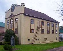 South Fallsburg Hebrew Association Synagogue |
November 22, 2000 (#00001410) |
North St. 41°42′25″N 74°37′51″W |
South Fallsburg | Originally built in 1902, is one of oldest synagogues in county. Has full sukkah in basement. |
| 71 | Spring House | 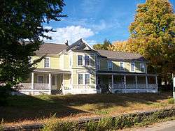 Spring House |
December 2, 2009 (#09000970) |
54 River Rd. 41°28′41″N 74°55′07″W |
Barryville | New listing; refnum 09000970 |
| 72 | Stone Arch Bridge | 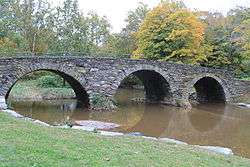 Stone Arch Bridge |
December 12, 1976 (#76001285) |
N of Kenoza Lake on NY 52 41°44′53″N 74°57′15″W |
Kenoza Lake | |
| 73 | Tefereth Israel Anshei Parksville Synagogue | 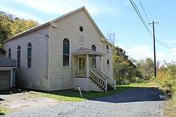 Tefereth Israel Anshei Parksville Synagogue |
August 12, 1999 (#99000990) |
Dead End St. 41°51′28″N 74°45′45″W |
Parksville | |
| 74 | Ten Mile River Baptist Church | 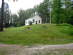 Ten Mile River Baptist Church |
May 9, 1997 (#97000422) |
NY 97, jct. with Cochecton Trnpk. 41°33′36″N 75°01′00″W |
Tusten | |
| 75 | Town and Country Building | 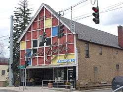 Town and Country Building |
September 24, 2004 (#04001061) |
1 N Main St. 41°47′59″N 74°44′45″W |
Liberty | |
| 76 | Tusten Stone Arch Bridge | .jpg) Tusten Stone Arch Bridge |
July 27, 2000 (#00000839) |
Tusten Rd. at Ten Mile River 41°33′22″N 75°01′10″W |
Tusten | |
| 77 | Valleau Tavern | 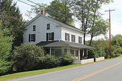 Valleau Tavern |
November 27, 1992 (#92001599) |
Jct. of Co. Rd. 114 and NY 97 41°42′37″N 75°03′16″W |
Cochecton | |
| 78 | Woodbourne Reformed Church Complex | 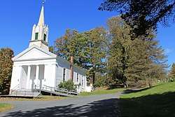 Woodbourne Reformed Church Complex |
November 7, 2003 (#03001120) |
NY 42 41°45′42″N 74°36′00″W |
Woodbourne | |
| 79 | Woodstock Music Festival Site | 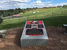 Woodstock Music Festival Site |
February 28, 2017 (#100000684) |
Generally West Shore, Best, and Perry roads 41°42′05″N 74°52′49″W |
Bethel | Farmland used for 1969 Woodstock music festival, a touchstone event of late 1960s counterculture |
References
- The latitude and longitude information provided in this table was derived originally from the National Register Information System, which has been found to be fairly accurate for about 99% of listings. Some locations in this table may have been corrected to current GPS standards.
- "National Register of Historic Places: Weekly List Actions". National Park Service, United States Department of the Interior. Retrieved on June 19, 2020.
- Numbers represent an ordering by significant words. Various colorings, defined here, differentiate National Historic Landmarks and historic districts from other NRHP buildings, structures, sites or objects.
- The eight-digit number below each date is the number assigned to each location in the National Register Information System database, which can be viewed by clicking the number.
- Whitman, Victor (9 April 2011). "Historic building to be demolished". Times Herald-Record. Retrieved 10 July 2017.
The demolition crews are there right now
| Topics |  | |
|---|---|---|
| Lists by county |
| |
| Lists by city | ||
| Other lists | ||
| ||
| Wikimedia Commons has media related to National Register of Historic Places in Sullivan County, New York. |
This article is issued from Wikipedia. The text is licensed under Creative Commons - Attribution - Sharealike. Additional terms may apply for the media files.