National Register of Historic Places listings in southern Westchester County, New York
This is a list of the National Register of Historic Places listings in southern Westchester County, New York, excluding the cities of New Rochelle and Yonkers, which have separate lists of their own.
This is intended to be a complete list of the properties and districts on the National Register of Historic Places in the southern half of Westchester County, New York, United States. The following communities comprise this region:
- Town of Eastchester, including the villages of Bronxville and Tuckahoe, and the hamlet of Crestwood
- Town of Greenburgh, excluding Tarrytown but including the villages of Ardsley, Dobbs Ferry, Elmsford, Hastings-on-Hudson, and Irvington, and the hamlets of Edgemont and Hartsdale
- Village and town of Harrison
- Town of Mamaroneck, including the villages of Larchmont and Mamaroneck
- City of Mount Vernon
- Town of Pelham, which is the villages of Pelham and Pelham Manor
- City of Rye
- Town of Rye, including the villages of Port Chester and Rye Brook
- Village and town of Scarsdale
- City of White Plains
Latitude and longitude coordinates are provided for many National Register properties and districts; these locations may be seen together in Google Maps.[1]
Of the 233 properties and districts listed on the National Register in the county, 88, including six National Historic Landmarks (NHLs), are on this list. Two, the Bronx River Parkway and Old Croton Aqueduct, the latter an NHL, are linear listings included on both this list and the northern Westchester list.
- This National Park Service list is complete through NPS recent listings posted June 19, 2020.[2]
| Albany (Albany) – Allegany – Bronx – Broome – Cattaraugus – Cayuga – Chautauqua – Chemung – Chenango – Clinton – Columbia – Cortland – Delaware – Dutchess (Poughkeepsie, Rhinebeck) – Erie (Buffalo) – Essex – Franklin – Fulton – Genesee – Greene – Hamilton – Herkimer – Jefferson – Kings – Lewis – Livingston – Madison – Monroe (Rochester) – Montgomery – Nassau – New York (Below 14th Street, 14th to 59th Streets, 59th to 110th Streets, Above 110th Street, Islands) – Niagara – Oneida – Onondaga – Ontario – Orange – Orleans – Oswego – Otsego – Putnam – Queens – Rensselaer – Richmond – Rockland – St. Lawrence – Saratoga – Schenectady – Schoharie – Schuyler – Seneca – Steuben – Suffolk – Sullivan – Tioga – Tompkins – Ulster – Warren – Washington – Wayne – Westchester (Northern, Southern, New Rochelle, Peekskill, Yonkers) – Wyoming – Yates |
Current listings
| [3] | Name on the Register | Image | Date listed[4] | Location | City or town | Description |
|---|---|---|---|---|---|---|
| 1 | African Cemetery |  African Cemetery |
October 3, 2003 (#03000999) |
North St. 40°58′34″N 73°42′12″W |
Rye | Historic segregated cemetery, established in 1860 and used until 1964, including burial of veterans from the Civil War through World War II; located within Greenwood Union Cemetery. |
| 2 | Armour-Stiner House | 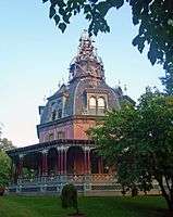 Armour-Stiner House |
December 18, 1975 (#75001238) |
45 W. Clinton Ave. 41°01′51″N 73°52′16″W |
Irvington | Possibly the only domed octagon house in the world |
| 3 | Bar Building | 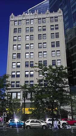 Bar Building |
May 17, 2007 (#07000331) |
199 Main St. 41°01′57″N 73°46′05″W |
White Plains | |
| 4 | Bird Homestead |  Bird Homestead |
February 22, 2010 (#10000032) |
600 Milton Rd. 40°57′34″N 73°41′21″W |
Rye | Original Greek Revival home built in 1835 with several farm buildings of the Bird family |
| 5 | Bolton Priory | 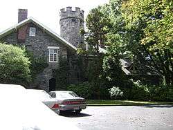 Bolton Priory |
June 28, 1974 (#74001320) |
7 Priory Lane 40°53′13″N 73°47′45″W |
Pelham Manor | |
| 6 | Evangeline Booth House |  Evangeline Booth House |
February 22, 2011 (#11000040) |
101 N. Central Ave. 41°01′12″N 73°47′50″W |
Hartsdale | |
| 7 | Boston Post Road Historic District | 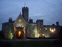 Boston Post Road Historic District |
October 29, 1982 (#82001275) |
Roughly bounded by Boston Post Rd. and Milton Harbor 40°57′17″N 73°42′01″W |
Rye | The only National Historic Landmark District in Westchester County. Includes the childhood home of Founding Father John Jay, and a nature preserve. |
| 8 | Bronx River Parkway Reservation |  Bronx River Parkway Reservation |
January 11, 1991 (#90002143) |
Bronx River Pkwy. from jct. with Sprain Brook Rd. to and including Kensico Dam Plaza 41°00′59″N 73°47′47″W |
Valhalla and Bronxville | |
| 9 | Bronxville Women's Club | 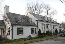 Bronxville Women's Club |
October 3, 2007 (#07001041) |
135 Midland Ave. 40°56′30″N 73°49′35″W |
Bronxville | |
| 10 | Bush-Lyon Homestead | 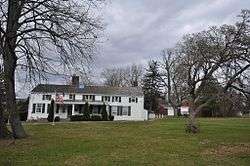 Bush-Lyon Homestead |
April 22, 1982 (#82003412) |
John Lyon Park, King St. 41°00′48″N 73°40′03″W |
Port Chester | |
| 11 | Capitol Theater |  Capitol Theater |
June 7, 1984 (#84003426) |
147-151 Westchester Ave. 41°00′06″N 73°39′56″W |
Port Chester | |
| 12 | Church of St. Barnabas |  Church of St. Barnabas |
March 24, 2000 (#00000241) |
15 N Broadway 41°02′23″N 73°51′57″W |
Irvington | 1853 stone Gothic Revival church has included Washington Irving, Philip Schuyler and Jay Gould as members |
| 13 | Church of St. Joseph of Arimathea |  Church of St. Joseph of Arimathea |
January 11, 2002 (#01001439) |
2172 Saw Mill River Rd. 41°02′37″N 73°49′46″W |
Greenburgh | |
| 14 | Jasper F. Cropsey House and Studio | .tif.jpg) Jasper F. Cropsey House and Studio |
May 17, 1973 (#73001287) |
49 Washington Ave. 40°59′35″N 73°52′55″W |
Hastings-on-Hudson | |
| 15 | Old Croton Aqueduct | 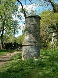 Old Croton Aqueduct |
December 2, 1974 (#74001324) |
Runs N from Yonkers to New Croton Dam 41°00′52″N 73°53′14″W |
Various | First long-distance aqueduct built to provide water from upstate to New York City. An engineering marvel in its time now used as a linear park |
| 16 | John William Draper House | 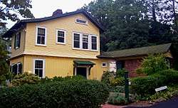 John William Draper House |
May 15, 1975 (#75001237) |
407 Broadway 40°59′29″N 73°52′47″W |
Hastings-on-Hudson | Home of astrophotography pioneer John William Draper, who in the 1840s took the first recognizable photo of the moon through a telescope at his observatory here. |
| 17 | East Irvington School | 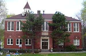 East Irvington School |
October 6, 1983 (#83004216) |
Taxter Rd. 41°02′46″N 73°51′21″W |
East Irvington | Late 19th-century school built for children of growing Irish immigrant population; now apartments. |
| 18 | Edgewood House |  Edgewood House |
June 26, 1986 (#86001388) |
908 Edgewood Ave. 40°53′41″N 73°49′13″W |
Pelham Manor | |
| 19 | Elmsford Reformed Church and Cemetery |  Elmsford Reformed Church and Cemetery |
September 15, 1983 (#83001828) |
30 S. Central Ave. 41°03′14″N 73°49′15″W |
Elmsford | Congregation organized in 1790; church building erected three years later is oldest building in village and oldest church in continuous use in county |
| 20 | Estherwood and Carriage House | 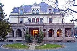 Estherwood and Carriage House |
November 20, 1979 (#79001646) |
Clinton Ave. 41°00′46″N 73°52′21″W |
Dobbs Ferry | Late 19th-century mansion and estate of industrial tycoon James Jenning McComb; now part of The Masters School, which he helped endow. |
| 21 | First United Methodist Church |  First United Methodist Church |
January 7, 2000 (#99001656) |
226 E. Lincoln Ave. 40°55′06″N 73°49′47″W |
Mount Vernon | |
| 22 | Leo Friedlander Studio | 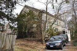 Leo Friedlander Studio |
July 29, 1982 (#82003416) |
825 W. Hartsdale Rd. 41°02′35″N 73°48′34″W |
Greenburgh | |
| 23 | Good Counsel Complex |  Good Counsel Complex |
April 25, 1997 (#97000358) |
52 N. Broadway 41°02′21″N 73°45′52″W |
White Plains | |
| 24 | Percy Grainger Home and Studio | 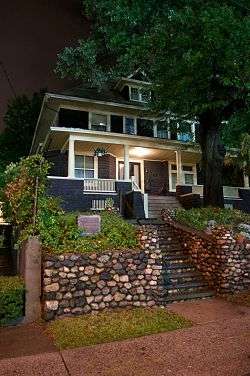 Percy Grainger Home and Studio |
April 8, 1993 (#93000234) |
7 Cromwell Pl. 41°01′38″N 73°46′02″W |
White Plains | |
| 25 | Hadden-Margolis House | 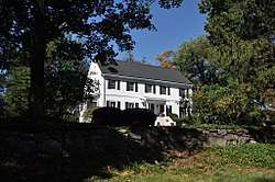 Hadden-Margolis House |
March 7, 2008 (#08000146) |
61 Winfield Ln. 40°58′19″N 73°44′16″W |
Harrison | |
| 26 | Hartsdale Pet Cemetery | 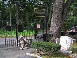 Hartsdale Pet Cemetery |
August 17, 2012 (#12000535) |
75 N. Central Park Ave. 41°01′17″N 73°47′49″W |
Hartsdale | |
| 27 | Hartsdale Railroad Station | 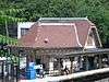 Hartsdale Railroad Station |
July 14, 2011 (#11000453) |
1 E. Hartsdale Ave. 41°00′40″N 73°47′45″W |
Hartsdale | 1915 railroad station building |
| 28 | Hastings Prototype House |  Hastings Prototype House |
December 19, 1991 (#91001873) |
546 Farragut Pkwy. 40°59′04″N 73°52′17″W |
Hastings-on-Hudson | 1936 Moderne house, built by local developer, was meant to be pattern for a housing development in Florida that was never built. Architect's only work in this style. |
| 29 | Widow Haviland's Tavern |  Widow Haviland's Tavern |
April 16, 1974 (#74001322) |
Purchase St. 40°58′55″N 73°41′05″W |
Rye | |
| 30 | Caleb Hyatt House | 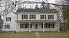 Caleb Hyatt House |
January 22, 1973 (#73001291) |
937 White Plains Post Rd. 40°58′54″N 73°48′00″W |
Scarsdale | |
| 31 | Hyatt-Livingston House | _(14574250168).jpg) Hyatt-Livingston House |
October 5, 1972 (#72000917) |
152 Broadway 41°00′32″N 73°52′45″W |
Dobbs Ferry | Burned down in 1974 |
| 32 | Irvington Historic District | 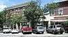 Irvington Historic District |
January 15, 2014 (#13001095) |
N. & S. Astor, Broadway, Buckhout, Cottenet, Dearman, Dutcher, Eckar & Ferris Sts., Bridge St., E. & W. Home Pl. 41°02′21″N 73°52′20″W |
Irvington | Historic core of small riverside suburb; See map |
| 33 | Irvington Town Hall | 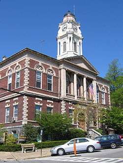 Irvington Town Hall |
November 1, 1984 (#84000205) |
85 Main St. 41°02′25″N 73°52′06″W |
Irvington | Built in 1902, early use of Colonial Revival in a civic building. Upper floors have an auditorium for performances and community gatherings, was home to public library until 2000. |
| 34 | Timothy Knapp House and Milton Cemetery | 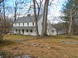 Timothy Knapp House and Milton Cemetery |
June 14, 1982 (#82003413) |
265 Rye Beach Ave. and Milton Rd. 40°57′53″N 73°41′12″W |
Rye | Built between 1667 and 1670 by Timothy Knapp |
| 35 | Lawrence Park Historic District |  Lawrence Park Historic District |
January 23, 1980 (#80002788) |
Roughly bounded by Side Hill, Prescott, Kensington, Garden and Chestnut Ave., Maidens Ln., and Valley and Pondfield Rds. 40°56′27″N 73°50′19″W |
Bronxville | |
| 36 | Life Savers Building | 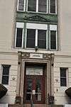 Life Savers Building |
July 11, 1985 (#85001496) |
N. Main St. 41°00′20″N 73°39′52″W |
Port Chester | Now a condominium complex |
| 37 | Lord and Burnham Building |  Lord and Burnham Building |
February 12, 1999 (#99000193) |
2 Main St. 41°02′22″N 73°52′23″W |
Irvington | 1870 building, home to eponymous maker of conservatories and greenhouses that supplied local estates, is now the village's library after lengthy restoration. |
| 38 | Mamaroneck Methodist Church | 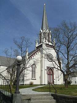 Mamaroneck Methodist Church |
October 2, 1992 (#92001304) |
514 Boston Post Rd. 40°57′05″N 73°43′48″W |
Mamaroneck | |
| 39 | Manor Club | 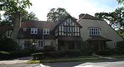 Manor Club |
May 12, 2014 (#14000207) |
1023 Esplanade 40°53′30″N 73°48′14″W |
Pelham Manor | |
| 40 | Mapleton | 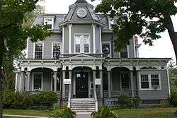 Mapleton |
September 28, 1976 (#76001295) |
52 N. Broadway 41°02′18″N 73°45′54″W |
White Plains | |
| 41 | Marble Schoolhouse |  Marble Schoolhouse |
July 6, 2005 (#05000663) |
388 California Rd. 40°55′53″N 73°48′41″W |
Eastchester | |
| 42 | Masterton-Dusenberry House |  Masterton-Dusenberry House |
April 16, 1980 (#80002789) |
90 White Plains Rd. 40°56′13″N 73°49′06″W |
Bronxville | |
| 43 | McVickar House |  McVickar House |
January 14, 2004 (#03001398) |
131 Main St. 41°02′20″N 73°51′57″W |
Irvington | 1853 Greek Revival house is second oldest on village's Main Street |
| 44 | New York, Westchester & Boston Railway Highbrook Avenue Bridge |  New York, Westchester & Boston Railway Highbrook Avenue Bridge |
August 2, 2016 (#16000487) |
Highbrook Ave. between Lincoln & Harmon Aves 40°54′50″N 73°48′17″W |
Pelham | Early example of a reinforced concrete arch bridge, dating to 1911 |
| 45 | Nuits |  Nuits |
April 13, 1977 (#77000986) |
Hudson Rd. and Clifton Pl. 41°01′29″N 73°52′31″W |
Ardsley-on-Hudson | 1852 Italian villa-style house was early work by Detlef Lienau; later home to Cyrus West Field and John Jacob Astor III. Only extant example of Lienau's early residential work. |
| 46 | Odell House |  Odell House |
March 28, 1973 (#73001286) |
425 Ridge Rd. 41°01′10″N 73°49′04″W |
Greenburgh | |
| 47 | Pelham Picture House |  Pelham Picture House |
May 28, 2010 (#10000305) |
175 Wolf's Lane 40°54′26″N 73°48′41″W |
Pelham | |
| 48 | Pelhamdale |  Pelhamdale |
November 4, 1982 (#82001276) |
45 Iden Ave. 40°54′03″N 73°48′55″W |
Pelham Manor | |
| 49 | Peoples National Bank and Trust Company Building | 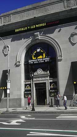 Peoples National Bank and Trust Company Building |
September 14, 2000 (#00001119) |
31 Mamaroneck Ave. 41°01′54″N 73°46′00″W |
White Plains | |
| 50 | Playland Amusement Park | 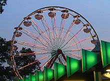 Playland Amusement Park |
July 4, 1980 (#80004529) |
Playland Pkwy. and Forest Ave. 40°58′08″N 73°40′17″W |
Rye | An early example of an amusement park designed for visitors by car as opposed to public transit; Art Deco stylings on attractions widely copied |
| 51 | Presbyterian Rest for Convalescents |  Presbyterian Rest for Convalescents |
April 27, 2011 (#11000230) |
69 N. Broadway 41°02′19″N 73°46′03″W |
White Plains | |
| 52 | Jacob Purdy House | 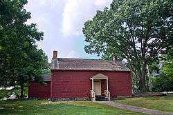 Jacob Purdy House |
August 31, 1979 (#79001651) |
60 Park Ave. 41°02′12″N 73°46′26″W |
White Plains | |
| 53 | Putnam and Mellor Engine and Hose Company Firehouse | 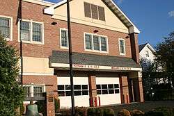 Putnam and Mellor Engine and Hose Company Firehouse |
September 15, 1983 (#83001831) |
46 S. Main St. 40°59′58″N 73°39′55″W |
Port Chester | Torn down in 2007 |
| 54 | Reid Hall, Manhattanville College |  Reid Hall, Manhattanville College |
March 22, 1974 (#74001321) |
Manhattanville College, Purchase St. 41°01′56″N 73°42′58″W |
Purchase | |
| 55 | Romer-Van Tassel House |  Romer-Van Tassel House |
November 25, 1994 (#94001373) |
2121 Saw Mill River Rd. 41°02′39″N 73°49′40″W |
Greenburgh | |
| 56 | Rye Meeting House |  Rye Meeting House |
January 14, 2011 (#10001134) |
624 Milton Rd. 40°57′31″N 73°41′20″W |
Rye | Original one room school house built in the 1830s, used as a chapel and later as a Quaker meeting house. Built in the Gothic Revival style. |
| 57 | Rye Town Park-Bathing Complex and Oakland Beach |  Rye Town Park-Bathing Complex and Oakland Beach |
April 18, 2003 (#03000252) |
Forrest Ave., bet. Rye Beach and Dearborn Ave. 40°57′39″N 73°40′45″W |
Rye | |
| 58 | St. Paul's Church National Historic Site |  St. Paul's Church National Historic Site |
October 15, 1966 (#66000580) |
Eastchester 40°53′36″N 73°49′33″W |
Mount Vernon | |
| 59 | St. Peter's Episcopal Church | 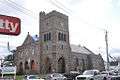 St. Peter's Episcopal Church |
April 12, 2006 (#06000260) |
19 Smith St. 41°00′14″N 73°40′01″W |
Port Chester | |
| 60 | St. Thomas' Episcopal Church Complex | 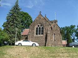 St. Thomas' Episcopal Church Complex |
August 12, 2003 (#03000242) |
158-168 W. Boston Post Rd. 40°56′53″N 73°44′07″W |
Mamaroneck | |
| 61 | Scarsdale Railroad Station | .jpg) Scarsdale Railroad Station |
July 27, 2000 (#00000837) |
Popham Rd. at Bronx River Pkwy. 40°59′22″N 73°48′32″W |
Scarsdale | |
| 62 | Scarsdale Woman's Club | 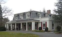 Scarsdale Woman's Club |
February 29, 2008 (#08000110) |
37 Drake Rd. 40°59′14″N 73°47′36″W |
Scarsdale | |
| 63 | Skinny House | 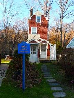 Skinny House |
May 18, 2015 (#15000235) |
175 Grand St. 40°57′17″N 73°44′33″W |
Mamaroneck | Depression-era house built by African-American architect on small parcel |
| 64 | Soundview Manor |  Soundview Manor |
November 25, 2009 (#09000957) |
283 Soundview Ave. 41°00′15″N 73°45′55″W |
White Plains | |
| 65 | South Presbyterian Church | 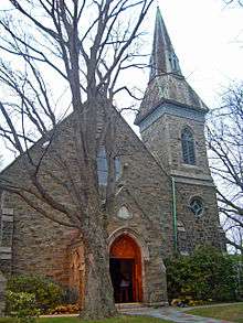 South Presbyterian Church |
May 26, 2000 (#00000548) |
343 Broadway 41°00′53″N 73°52′22″W |
Dobbs Ferry | 1869 stone Gothic Revival church is the only known building by Julius Munckowitz, later involved in developing New York City's park system |
| 66 | Spanish American War Monument to the 71st Infantry Regiment |  Spanish American War Monument to the 71st Infantry Regiment |
January 14, 2011 (#10001133) |
Jackson Avenue & Saw Mill River Road 41°00′38″N 73°51′50″W |
Greenburgh | |
| 67 | John Stevens House |  John Stevens House |
April 26, 1972 (#72000919) |
29 W. 4th St. 40°54′15″N 73°50′08″W |
Mount Vernon | |
| 68 | Stony Hill Cemetery |  Stony Hill Cemetery |
June 25, 1999 (#99000753) |
Buckout Rd. 41°03′18″N 73°44′59″W |
Harrison | |
| 69 | Trinity Episcopal Church Complex |  Trinity Episcopal Church Complex |
September 1, 1998 (#97001494) |
335 Fourth Ave. 40°54′11″N 73°50′02″W |
Mount Vernon | |
| 70 | Tuckahoe High School |  Tuckahoe High School |
February 24, 2010 (#10000045) |
65 Siwanoy Blvd. 40°56′31″N 73°48′49″W |
Eastchester | |
| 71 | US Post Office-Bronxville | 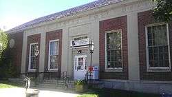 US Post Office-Bronxville |
November 17, 1988 (#88002459) |
119 Pondfield Rd.[5] 40°56′18″N 73°49′57″W |
Bronxville | part of the US Post Offices in New York State, 1858-1943, TR |
| 72 | US Post Office-Dobbs Ferry |  US Post Office-Dobbs Ferry |
November 17, 1988 (#88002484) |
120 Main St.[6] 41°00′55″N 73°52′30″W |
Dobbs Ferry | One of many New Deal-era Colonial Revival post offices in the state; one of only three with parapeted gables and window keystones; part of the US Post Offices in New York State, 1858-1943, TR |
| 73 | US Post Office-Harrison | 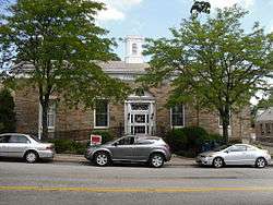 US Post Office-Harrison |
May 11, 1989 (#88002524) |
258 Halstead Ave. 40°58′07″N 73°42′51″W |
Harrison | part of the US Post Offices in New York State, 1858-1943, TR |
| 74 | US Post Office-Larchmont |  US Post Office-Larchmont |
May 11, 1989 (#88002341) |
1 Chatsworth Ave. 40°55′48″N 73°45′05″W |
Larchmont | part of the US Post Offices in New York State, 1858-1943, TR |
| 75 | US Post Office-Mount Vernon |  US Post Office-Mount Vernon |
May 11, 1989 (#88002355) |
15 S. First St. 40°54′40″N 73°50′02″W |
Mount Vernon | part of the US Post Offices in New York State, 1858-1943, TR |
| 76 | US Post Office-Port Chester |  US Post Office-Port Chester |
May 11, 1989 (#88002406) |
245 Westchester Ave. 41°00′12″N 73°40′07″W |
Port Chester | part of the US Post Offices in New York State, 1858-1943, TR |
| 77 | US Post Office-Rye |  US Post Office-Rye |
May 11, 1989 (#88002426) |
41 Purdy Ave. 40°59′04″N 73°40′59″W |
Rye | part of the US Post Offices in New York State, 1858-1943, TR |
| 78 | US Post Office-Scarsdale | 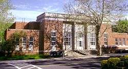 US Post Office-Scarsdale |
May 11, 1989 (#88002428) |
29 Chase Rd.[7] 40°59′24″N 73°48′22″W |
Scarsdale | part of the US Post Offices in New York State, 1858-1943, TR |
| 79 | Villa Lewaro | 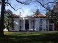 Villa Lewaro |
May 11, 1976 (#76001289) |
N. Broadway 41°02′00″N 73°51′56″W |
Irvington | Home of Madame C.J. Walker, hair-care products tycoon and first African-American millionaire. |
| 80 | Walter's Hot Dog Stand |  Walter's Hot Dog Stand |
June 11, 2010 (#10000338) |
937 Palmer Ave. 40°56′35″N 73°44′49″W |
Mamaroneck | 1928 imitation pagoda |
| 81 | William E. Ward House | 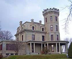 William E. Ward House |
November 7, 1976 (#76001294) |
Comly Ave. 41°01′34″N 73°40′03″W |
Rye Brook | First reinforced concrete structure in U.S., built in the 1870s on state line. Extends into Greenwich, Connecticut |
| 82 | Washington Irving Memorial | Washington Irving Memorial |
September 8, 2000 (#00001062) |
Broadway and Sunnyside Ln. 41°02′53″N 73°51′43″W |
Irvington | Daniel Chester French-sculpted memorial to writer who gave Irvington its name, erected in the late 1920s. |
| 83 | Wayside Cottage |  Wayside Cottage |
May 1, 1981 (#81000418) |
1039 Post Rd. 40°59′32″N 73°47′40″W |
Scarsdale | |
| 84 | White Plains Armory | 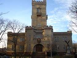 White Plains Armory |
April 16, 1980 (#80002796) |
35 S. Broadway 41°01′53″N 73°45′47″W |
White Plains | |
| 85 | White Plains Rural Cemetery | 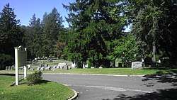 White Plains Rural Cemetery |
September 19, 2003 (#03000247) |
167 N. Broadway 41°02′50″N 73°46′20″W |
White Plains | |
| 86 | Albert E. and Emily Wilson House |  Albert E. and Emily Wilson House |
April 18, 2007 (#07000330) |
617 Brook St. 40°57′16″N 73°43′46″W |
Mamaroneck | |
| 87 | Winged Foot Golf Club |  Winged Foot Golf Club |
June 12, 2019 (#100004089) |
851 Fenimore Rd. 40°57′28″N 73°45′13″W |
Mamaroneck | Country club with two golf courses completed in 1923 is last designed by A.W. Tillinghast that features a Clifford Charles Wendehack clubhouse; has hosted several U.S. Opens |
| 88 | Woman's Club of White Plains |  Woman's Club of White Plains |
October 20, 2010 (#10000853) |
305 Ridgeway 41°00′23″N 73°44′54″W |
White Plains |
See also
| Wikimedia Commons has media related to National Register of Historic Places in Westchester County, New York. |
References
- The latitude and longitude information provided in this table was derived originally from the National Register Information System, which has been found to be fairly accurate for about 99% of listings. Some locations in this table may have been corrected to current GPS standards.
- "National Register of Historic Places: Weekly List Actions". National Park Service, United States Department of the Interior. Retrieved on June 19, 2020.
- Numbers represent an ordering by significant words. Various colorings, defined here, differentiate National Historic Landmarks and historic districts from other NRHP buildings, structures, sites or objects.
- The eight-digit number below each date is the number assigned to each location in the National Register Information System database, which can be viewed by clicking the number.
- Address based on USPS website. Accessed April 2, 2016.
- Address based on USPS website. Accessed April 2, 2016.
- Address based on USPS website. Accessed April 2, 2016.
Further reading
- Williams, Gray (2003). Picturing Our Past: National Register Sites in Westchester County. Westchester County Historical Society. ISBN 0-915585-14-6.
| Topics |  | |
|---|---|---|
| Lists by county |
| |
| Lists by city | ||
| Other lists | ||
| ||