National Register of Historic Places listings in Wayne County, New York
List of the National Register of Historic Places listings in Wayne County, New York
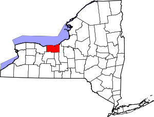
Location of Wayne County in New York
This is intended to be a complete list of properties and districts listed on the National Register of Historic Places in Wayne County, New York. The locations of National Register properties and districts (at least for all showing latitude and longitude coordinates below) may be seen in a map by clicking on "Map of all coordinates".[1]
- This National Park Service list is complete through NPS recent listings posted June 19, 2020.[2]
| Albany (Albany) – Allegany – Bronx – Broome – Cattaraugus – Cayuga – Chautauqua – Chemung – Chenango – Clinton – Columbia – Cortland – Delaware – Dutchess (Poughkeepsie, Rhinebeck) – Erie (Buffalo) – Essex – Franklin – Fulton – Genesee – Greene – Hamilton – Herkimer – Jefferson – Kings – Lewis – Livingston – Madison – Monroe (Rochester) – Montgomery – Nassau – New York (Below 14th Street, 14th to 59th Streets, 59th to 110th Streets, Above 110th Street, Islands) – Niagara – Oneida – Onondaga – Ontario – Orange – Orleans – Oswego – Otsego – Putnam – Queens – Rensselaer – Richmond – Rockland – St. Lawrence – Saratoga – Schenectady – Schoharie – Schuyler – Seneca – Steuben – Suffolk – Sullivan – Tioga – Tompkins – Ulster – Warren – Washington – Wayne – Westchester (Northern, Southern, New Rochelle, Peekskill, Yonkers) – Wyoming – Yates |
Listings county-wide
| [3] | Name on the Register | Image | Date listed[4] | Location | City or town | Description |
|---|---|---|---|---|---|---|
| 1 | Alasa Farms |  Alasa Farms |
October 16, 2009 (#09000835) |
6450 Shaker Rd. 43°12′41″N 76°58′48″W |
Alton | |
| 2 | J. and E. Baker Cobblestone Farmstead |  J. and E. Baker Cobblestone Farmstead |
November 7, 1995 (#95001281) |
815 Canandaigua Rd. 43°02′04″N 77°18′50″W |
Macedon | |
| 3 | Brick Church Corners | 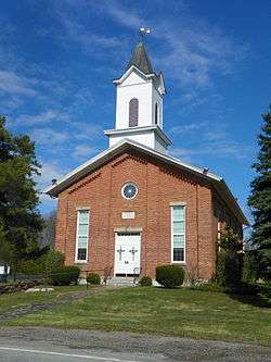 Brick Church Corners |
June 5, 1974 (#74001317) |
Jct. of Brick Church and Ontario Center Rds. 43°15′27″N 77°18′21″W |
Ontario | |
| 4 | Broad Street-Water Street Historic District |  Broad Street-Water Street Historic District |
August 14, 1973 (#73001284) |
Broad and Water Sts. 43°03′45″N 76°59′43″W |
Lyons | |
| 5 | Charles Bullis House | 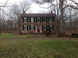 Charles Bullis House |
March 20, 1986 (#86000483) |
1727 Canandaigua Rd. 43°04′10″N 77°19′14″W |
Macedon | |
| 6 | Clyde Downtown Historic District |  Clyde Downtown Historic District |
December 23, 2019 (#100004803) |
Portions of Glasgow St., Caroline St., Columbia St., Sodus St., North & South Park, & West Genesee St. 43°05′03″N 76°52′14″W |
Clyde | Core of village that developed around a local park from 1820 on, spurred by Erie Canal |
| 7 | Customs House | May 6, 1980 (#80002787) |
Sentell St. 43°16′01″N 76°59′37″W |
Sodus Point | ||
| 8 | Dipper Dredge No. 3 | 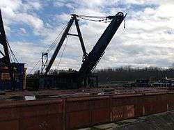 Dipper Dredge No. 3 |
December 11, 2007 (#07001257) |
1665 Drydock Rd. 43°03′52″N 77°01′10″W |
Lyons | |
| 9 | East Main Street Commercial Historic District | 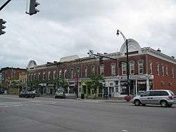 East Main Street Commercial Historic District |
November 21, 1974 (#74001318) |
Between Clinton and William-Cuyler Sts. 43°03′49″N 77°13′49″W |
Palmyra | |
| 10 | East Palmyra Presbyterian Church | December 31, 2002 (#02001651) |
2102 Whitbeck Rd. 43°05′02″N 77°08′52″W |
East Palmyra | ||
| 11 | First Methodist Episcopal Church of Walworth | March 27, 2017 (#100000814) |
3679 Main St. 43°08′17″N 77°16′23″W |
Walworth | Landmark in the community since its 1872 construction | |
| 12 | First Presbyterian Church of Ontario Center | 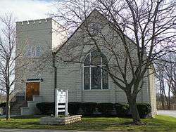 First Presbyterian Church of Ontario Center |
June 3, 1998 (#98000665) |
1638 Ridge Rd. 43°13′31″N 77°18′06″W |
Ontario Center | |
| 13 | Gates Hall and Pultneyville Public Square | 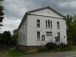 Gates Hall and Pultneyville Public Square |
March 3, 2000 (#00000177) |
Lake Rd. 43°16′48″N 77°11′13″W |
Pultneyville | |
| 14 | Grace Episcopal Church Complex |  Grace Episcopal Church Complex |
August 19, 1994 (#94000802) |
7-9 Phelps St. and 12 Lawrence St. 43°03′55″N 76°59′25″W |
Lyons | |
| 15 | H. G. Hotchkiss Essential Oil Company Plant | 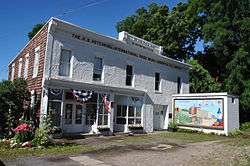 H. G. Hotchkiss Essential Oil Company Plant |
November 2, 1987 (#87001897) |
93-95 Water St. 43°03′46″N 76°59′48″W |
Lyons | |
| 16 | Jackson-Perkins House | 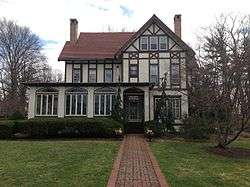 Jackson-Perkins House |
July 14, 2006 (#06000567) |
310 High St. 43°02′39″N 77°05′58″W |
Newark | |
| 17 | Ambrose S. Lapham House | September 3, 2014 (#14000541) |
352 W. Jackson St. 43°03′38″N 77°14′36″W |
Palmyra | 1870 Italianate brick house built by local resident who returned after a successful banking career in Detroit | |
| 18 | LOTUS (schooner) | 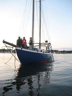 LOTUS (schooner) |
May 10, 1990 (#90000694) |
Trestle Landing Marina, Co. Rt. 14 at Sentell Rd. 43°15′59″N 76°59′29″W |
Sodus Point | |
| 19 | Lyons Downtown Historic District | 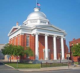 Lyons Downtown Historic District |
March 12, 2018 (#SG100002190) |
Broad bounded by Phelps, William, Butternut, Pearl & Canal with portions of Bear, Lawrence, Geneva & Water Sts. 43°03′48″N 76°59′36″W |
Lyons | Core of county seat, reflecting 18th century origins, 19th-century growth as canal town and 20th-century industrialization |
| 20 | Market Street Historic District |  Market Street Historic District |
December 8, 1972 (#72000916) |
Both sides of Market St. between Canal and Main Sts. 43°03′52″N 77°13′47″W |
Palmyra | |
| 21 | Methodist Episcopal Church of Butler | November 24, 1997 (#97001459) |
Butler Center Rd., jct. with Washburn Rd. 43°10′06″N 76°46′17″W |
Butler Center | ||
| 22 | New York State Barge Canal | 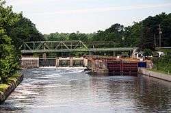 New York State Barge Canal |
October 15, 2014 (#14000860) |
Linear across county 43°03′55″N 77°14′47″W |
Arcadia, Clyde, Galen, Lyons, Newark, Palmyra, Savannah | Successor to Erie Canal approved by state voters in early 20th century to compete with railroads. |
| 23 | Palmyra Village Historic District | 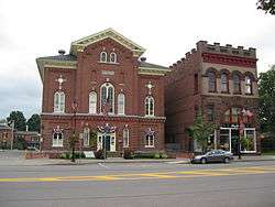 Palmyra Village Historic District |
October 16, 2009 (#09000836) |
Portions of Canandaigua, Church, Cuyler, E. and W. Jackson, Market, E. and W. Main Sts. 43°03′50″N 77°14′00″W |
Palmyra | |
| 24 | Ezra T. Phelps Farm Complex |  Ezra T. Phelps Farm Complex |
August 13, 1997 (#97000843) |
4365 E. Williamson Rd. 43°09′13″N 77°09′51″W |
Marion | |
| 25 | Preston-Gaylord Cobblestone Farmhouse |  Preston-Gaylord Cobblestone Farmhouse |
December 11, 2009 (#09001088) |
7563 Lake Rd. 43°15′57″N 77°01′28″W |
Sodus | |
| 26 | Pultneyville Historic District |  Pultneyville Historic District |
September 11, 1985 (#85002325) |
Sections of Lake Rd. and Jay St. 43°16′48″N 77°10′54″W |
Pultneyville | |
| 27 | Red Brick Church | _WAYNE_COUNTY.jpg) Red Brick Church |
December 8, 1997 (#97001527) |
Jct. of Brick Church Rd. and S. Geneva Rd. 43°11′58″N 77°00′42″W |
Sodus Center | |
| 28 | Roe Cobblestone Schoolhouse | September 17, 2008 (#08000920) |
12397 Van Vleck Rd. 43°11′25″N 76°47′00″W |
Butler | ||
| 29 | Smith-Ely Mansion | 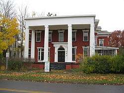 Smith-Ely Mansion |
February 10, 1992 (#92000032) |
39 W. Genesee St. 43°05′07″N 76°52′25″W |
Clyde | |
| 30 | Sodus Point Lighthouse | 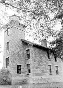 Sodus Point Lighthouse |
October 8, 1976 (#76001288) |
Off NY 14 at Lake Ontario 43°16′25″N 76°59′12″W |
Sodus Point | |
| 31 | St. Peter, (Shipwreck) | 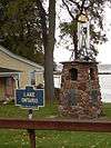 St. Peter, (Shipwreck) |
March 22, 2004 (#04000226) |
Address Restricted 43°18′42″N 77°07′52″W |
Pultneyville | |
| 32 | Towar-Ennis Farmhouse and Barn Complex | 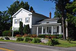 Towar-Ennis Farmhouse and Barn Complex |
October 16, 2009 (#09000967) |
265 NY-14 43°01′12″N 76°59′12″W |
Lyons | |
| 33 | US Post Office-Clyde | 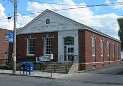 US Post Office-Clyde |
November 17, 1988 (#88002472) |
26 S. Park St. 43°05′01″N 76°52′16″W |
Clyde | |
| 34 | US Post Office-Lyons | 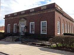 US Post Office-Lyons |
May 11, 1989 (#88002349) |
1-5 Pearl St. 43°03′46″N 76°59′37″W |
Lyons | |
| 35 | US Post Office-Newark | 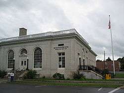 US Post Office-Newark |
May 11, 1989 (#88002366) |
300 S. Main St.[5] 43°02′37″N 77°05′43″W |
Newark | |
| 36 | Walling Cobblestone Tavern | 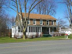 Walling Cobblestone Tavern |
March 17, 1994 (#94000173) |
7851 Ridge Rd., Hamlet of Wallington 43°13′18″N 77°00′44″W |
Sodus | |
| 37 | Wallington Cobblestone Schoolhouse District No. 8 | 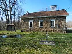 Wallington Cobblestone Schoolhouse District No. 8 |
March 17, 1994 (#94000172) |
6135 N. Geneva Rd., Hamlet of Wallington 43°13′23″N 77°00′48″W |
Sodus | |
| 38 | Wolcott Square Historic District |  Wolcott Square Historic District |
May 17, 2001 (#00001692) |
W. Main, Park, and New Hartford Sts. 43°13′12″N 76°48′58″W |
Wolcott | |
| 39 | Zion Episcopal Church |  Zion Episcopal Church |
November 29, 1996 (#96001388) |
100-120 Main St. 43°03′47″N 77°14′00″W |
Palmyra |
See also
| Wikimedia Commons has media related to National Register of Historic Places in Wayne County, New York. |
References
- The latitude and longitude information provided in this table was derived originally from the National Register Information System, which has been found to be fairly accurate for about 99% of listings. Some locations in this table may have been corrected to current GPS standards.
- "National Register of Historic Places: Weekly List Actions". National Park Service, United States Department of the Interior. Retrieved on June 19, 2020.
- Numbers represent an ordering by significant words. Various colorings, defined here, differentiate National Historic Landmarks and historic districts from other NRHP buildings, structures, sites or objects.
- The eight-digit number below each date is the number assigned to each location in the National Register Information System database, which can be viewed by clicking the number.
- Address based on USPS website. Accessed April 2, 2016.
| Topics |  | |
|---|---|---|
| Lists by county |
| |
| Lists by city | ||
| Other lists | ||
| ||
This article is issued from Wikipedia. The text is licensed under Creative Commons - Attribution - Sharealike. Additional terms may apply for the media files.