Verrières, Aveyron
| Verrières | |
|---|---|
| Commune | |
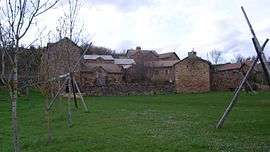 The hamlet of Bécours | |
 Verrières Location within Occitanie region  Verrières | |
| Coordinates: 44°12′08″N 3°03′32″E / 44.2022°N 3.0589°ECoordinates: 44°12′08″N 3°03′32″E / 44.2022°N 3.0589°E | |
| Country | France |
| Region | Occitanie |
| Department | Aveyron |
| Arrondissement | Millau |
| Canton | Tarn et Causses |
| Government | |
| • Mayor (2008–2014) | Jérôme Mouries |
| Area1 | 53.01 km2 (20.47 sq mi) |
| Population (2008)2 | 393 |
| • Density | 7.4/km2 (19/sq mi) |
| Time zone | UTC+1 (CET) |
| • Summer (DST) | UTC+2 (CEST) |
| INSEE/Postal code | 12291 /12520 |
| Elevation |
420–962 m (1,378–3,156 ft) (avg. 480 m or 1,570 ft) |
|
1 French Land Register data, which excludes lakes, ponds, glaciers > 1 km2 (0.386 sq mi or 247 acres) and river estuaries. 2 Population without double counting: residents of multiple communes (e.g., students and military personnel) only counted once. | |
Verrières is a commune in the Aveyron department in southern France.
Population
| Historical population | ||
|---|---|---|
| Year | Pop. | ±% |
| 1962 | 337 | — |
| 1968 | 368 | +9.2% |
| 1975 | 338 | −8.2% |
| 1982 | 351 | +3.8% |
| 1990 | 334 | −4.8% |
| 1999 | 342 | +2.4% |
| 2008 | 393 | +14.9% |
Geography
Nearby is the Verrières Viaduct on the A75 autoroute.
See also
References
| Wikimedia Commons has media related to Verrières, Aveyron. |
This article is issued from
Wikipedia.
The text is licensed under Creative Commons - Attribution - Sharealike.
Additional terms may apply for the media files.