Aguessac
| Aguessac | |
|---|---|
| Commune | |
 Chateau of Cabrières | |
 Aguessac Location within Occitanie region  Aguessac | |
| Coordinates: 44°09′27″N 3°05′57″E / 44.1575°N 3.0992°ECoordinates: 44°09′27″N 3°05′57″E / 44.1575°N 3.0992°E | |
| Country | France |
| Region | Occitanie |
| Department | Aveyron |
| Arrondissement | Millau |
| Canton | Millau-2 |
| Intercommunality | Millau Grands Causses |
| Government | |
| • Mayor (2014-2020) | Aimé Héral |
| Area1 | 17.64 km2 (6.81 sq mi) |
| Population (2014)2 | 861 |
| • Density | 49/km2 (130/sq mi) |
| Time zone | UTC+1 (CET) |
| • Summer (DST) | UTC+2 (CEST) |
| INSEE/Postal code | 12002 /12520 |
| Elevation |
367–869 m (1,204–2,851 ft) (avg. 372 m or 1,220 ft) |
|
1 French Land Register data, which excludes lakes, ponds, glaciers > 1 km2 (0.386 sq mi or 247 acres) and river estuaries. 2 Population without double counting: residents of multiple communes (e.g., students and military personnel) only counted once. | |
Aguessac is a French commune in the Aveyron department in the Occitanie region of southern France.
The inhabitants of the commune are known as Nagassols or Nagassoles[1]
Geography
Aguessac is just south of the Massif Central and is located some 4 km north of Millau and 20 km south of Severac-le-Chateau. It can be accessed by the D29 road branching off the D911 in the west and continuing into the commune and south to the village. There is also the D809 coming from Millau in the south passing through the village and continuing north to join the A75 autoroute. The D907 goes north-east from the village to Riviere-sur-Tarn and the D167 goes west by a tortuous mountain route to Saint-Germain. The famous Millau Viaduct (Viaduc de la Garrigue) is on the A75 autoroute immediately to the west of the commune. The commune is mixed forest and high country farmland.[2]
There are many streams flowing through the commune: the Ruisseau de Malbose forms the northern border of the commune, the Lumansonesque forms the eastern border flowing into the Tarn which forms the southern part of the eastern border. The Lumansonesque is fed by the Barbade with its numerous tributaries which forms part of the western border before flowing across the commune and joining the Lumansonesque.[2]
Neighbouring communes and villages[2]
Places adjacent to Aguessac | |
|---|---|
Administration
List of Successive Mayors of Aguessac
| From | To | Name |
|---|---|---|
| 1793 | 1795 | Guillaume Assayrous |
| 1795 | 1799 | Alexandre Baldet |
| 1800 | 1806 | Jean Amans Barascut |
| 1807 | 1816 | Jean Joseph Quezac |
| 1816 | 1822 | Jean Magloire |
| 1823 | 1827 | Jean Antoine Fabre |
| 1826 | 1829 | Jean Baptiste Colliere |
| 1829 | 1830 | François Julien |
| 1830 | 1836 | Jean-Joseph Quezac |
| 1836 | 1840 | Camille Triadou |
| 1840 | 1847 | Jean-Joseph Quezac |
| 1847 | 1848 | Camille Triadou |
| 1848 | 1852 | Jean-Antoine Alegre |
| 1852 | 1865 | Jean-Pierre Decombis |
| 1865 | 1876 | René Demnes |
| 1876 | 1878 | Victor Vivier |
| 1878 | 1881 | Jean-Joseph Demnes |
| 1881 | 1884 | Jean-Joseph Quezac |
| 1884 | 1904 | Sylvain Baldeyrou |
| 1904 | 1912 | Camille Benoit |
| 1912 | 1925 | Louis Rascalou |
| 1925 | 1926 | Amédé Baldeyrou |
- Mayors from 1926
| From | To | Name | Party | Position |
|---|---|---|---|---|
| 1926 | 1947 | Victor Arlabosse | ||
| 1947 | 1959 | Paul Bringuier | ||
| 1959 | 1965 | Jules Fau | ||
| 1965 | 1977 | Julien de Roquetaillade | ||
| 1977 | 1983 | Louis Vales | ||
| 1983 | 1989 | Julien de Roquetaillade | ||
| 1989 | 1995 | Louis Vales | ||
| 1995 | 2008 | Jacques Commayras | ||
| 2008 | 2020 | Aimé Heral |
(Not all data is known)
Demography
In 2010, the commune had 860 inhabitants. The evolution of the number of inhabitants is known through the population censuses conducted in the commune since 1793. From the 21st century, a census of communes with fewer than 10,000 inhabitants is held every five years, unlike larger towns that have a sample survey every year.[Note 1]
| 1793 | 1800 | 1806 | 1821 | 1831 | 1836 | 1841 | 1846 | 1851 |
|---|---|---|---|---|---|---|---|---|
| 575 | 629 | - | - | 748 | 771 | 763 | 773 | 760 |
| 1856 | 1861 | 1866 | 1872 | 1876 | 1881 | 1886 | 1891 | 1896 |
|---|---|---|---|---|---|---|---|---|
| 747 | 789 | 822 | 753 | 1,165 | 786 | 775 | 709 | 644 |
| 1901 | 1906 | 1911 | 1921 | 1926 | 1931 | 1936 | 1946 | 1954 |
|---|---|---|---|---|---|---|---|---|
| 668 | 686 | 631 | 597 | 579 | 645 | 608 | 596 | 712 |
| 1962 | 1968 | 1975 | 1982 | 1990 | 1999 | 2006 | 2010 | - |
|---|---|---|---|---|---|---|---|---|
| 731 | 709 | 714 | 615 | 811 | 833 | 832 | 860 | - |
Sources : Ldh/EHESS/Cassini until 1962, INSEE database from 1968 (population without double counting and municipal population from 2006)

Distribution of Age Groups
The gender and age of the population of the Aguessac commune in 2009 and, comparatively, that of the department of Aveyron in the same year are represented in the following table. The population of the commune was 53.6% men and 46.4% women in 2009. It has a structure on average slightly younger than the population of metropolitan France. There are in fact 117 young people under 20 years old for every 100 people over 60 years (giving a youth index of 1.17), while for France the youth index, which is equal to the division of the share of less than 20 years by the share of over 60 years, is 1.06. The Youth Index for the commune is also higher than for the department (0.67) and for of the region (0.89).
Percentage Distribution of Age Groups in Aguessac and Aveyron Department in 2009
| Aguessac | Aguessac | Aveyron | Aveyron | |
|---|---|---|---|---|
| Age Range | Men | Women | Men | Women |
| 0 to 14 Years | 22.9 | 17.0 | 16.7 | 15.1 |
| 15 to 29 Years | 14.1 | 12.8 | 15.1 | 13.4 |
| 30 to 44 Years | 22.9 | 22.0 | 18.9 | 17.8 |
| 45 to 59 Years | 21.4 | 24.2 | 21.6 | 20.3 |
| 60 to 74 Years | 10.1 | 11.1 | 16.9 | 17.5 |
| 75 to 89 Years | 8.6 | 11.4 | 10.2 | 14.2 |
| 90 Years+ | 0.0 | 1.5 | 0.6 | 1.7 |
Sources:
Economy
The economy of the commune is agricultural and characterized by traditional agriculture based on farming for the production of calves and lambs for fattening. There are twelve farms in this commune.
Sites and monuments
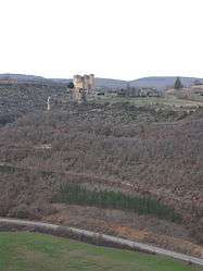
- The Chateau of Cabrières
Notable people linked to the commune
- Emma Calvé (1858-1942) at the height of her fame bought the Chateau of Cabrières in 1884 before selling it to a manufacturer of gloves a few years later.
See also
- Cantons of the Aveyron department
- Communes of the Aveyron department
- Arrondissements of the Aveyron department
External links
- Aguessac official website (in French)
- Aguessac on the old National Geographic Institute website (in French)
- Aguessac on Lion1906
- Aguessac on Google Maps
- Aguessac on Géoportail, National Geographic Institute (IGN) website (in French)
- Aguesac on the 1750 Cassini Map
- Aguessac on the INSEE website (in French)
- INSEE (in French)
Notes and references
Notes
- ↑ At the beginning of the 21st century, the methods of identification have been modified by law No. 2002-276 of 27 February 2002 Archived 2016-03-06 at the Wayback Machine., the so-called "law of local democracy" and in particular Title V "census operations" which allow, after a transitional period running from 2004 to 2008, the annual publication of the legal population of the different French administrative districts. For municipalities with a population greater than 10,000 inhabitants, a sample survey is conducted annually, the entire territory of these municipalities is taken into account at the end of the period of five years. The first "legal population" after 1999 under this new law came into force on 1 January 2009 and was based on the census of 2006.
References
- ↑ Inhabitants of Aveyron (in French)
- 1 2 3 Google Maps
| Wikimedia Commons has media related to Aguessac. |