Saint-Izaire
| Saint-Izaire | |
|---|---|
| Commune | |
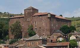 Chateau | |
 Saint-Izaire Location within Occitanie region  Saint-Izaire | |
| Coordinates: 43°58′32″N 2°43′17″E / 43.9756°N 2.7214°ECoordinates: 43°58′32″N 2°43′17″E / 43.9756°N 2.7214°E | |
| Country | France |
| Region | Occitanie |
| Department | Aveyron |
| Arrondissement | Millau |
| Canton | Saint-Affrique |
| Intercommunality | Saint-Affricain |
| Government | |
| • Mayor (2008–2014) | Jean-Jacques Sellam |
| Area1 | 34.48 km2 (13.31 sq mi) |
| Population (2008)2 | 325 |
| • Density | 9.4/km2 (24/sq mi) |
| Time zone | UTC+1 (CET) |
| • Summer (DST) | UTC+2 (CEST) |
| INSEE/Postal code | 12228 /12480 |
| Elevation |
234–620 m (768–2,034 ft) (avg. 240 m or 790 ft) |
|
1 French Land Register data, which excludes lakes, ponds, glaciers > 1 km2 (0.386 sq mi or 247 acres) and river estuaries. 2 Population without double counting: residents of multiple communes (e.g., students and military personnel) only counted once. | |
Saint-Izaire is a commune in the Aveyron department in southern France.
The Château de Saint-Izaire is a 14th-century episcopal castle.
Geography
The commune is traversed by the Dourdou de Camarès River.
Population
| Historical population | ||
|---|---|---|
| Year | Pop. | ±% |
| 1962 | 589 | — |
| 1968 | 495 | −16.0% |
| 1975 | 410 | −17.2% |
| 1982 | 337 | −17.8% |
| 1990 | 284 | −15.7% |
| 1999 | 317 | +11.6% |
| 2008 | 325 | +2.5% |
See also
References
| Wikimedia Commons has media related to Saint-Izaire. |
This article is issued from
Wikipedia.
The text is licensed under Creative Commons - Attribution - Sharealike.
Additional terms may apply for the media files.