Capdenac-Gare
| Capdenac-Gare | ||
|---|---|---|
| Commune | ||
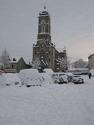 The church in Capdenac-Gare | ||
| ||
 Capdenac-Gare Location within Occitanie region  Capdenac-Gare | ||
| Coordinates: 44°34′21″N 2°04′54″E / 44.5725°N 2.0817°ECoordinates: 44°34′21″N 2°04′54″E / 44.5725°N 2.0817°E | ||
| Country | France | |
| Region | Occitanie | |
| Department | Aveyron | |
| Arrondissement | Villefranche-de-Rouergue | |
| Canton | Lot et Montbazinois | |
| Intercommunality | Figeac | |
| Government | ||
| • Mayor (2008–2014) | Stéphane Bérard | |
| Area1 | 20.21 km2 (7.80 sq mi) | |
| Population (2008)2 | 4,553 | |
| • Density | 230/km2 (580/sq mi) | |
| Time zone | UTC+1 (CET) | |
| • Summer (DST) | UTC+2 (CEST) | |
| INSEE/Postal code | 12052 /12700 | |
| Elevation |
156–421 m (512–1,381 ft) (avg. 163 m or 535 ft) | |
|
1 French Land Register data, which excludes lakes, ponds, glaciers > 1 km2 (0.386 sq mi or 247 acres) and river estuaries. 2 Population without double counting: residents of multiple communes (e.g., students and military personnel) only counted once. | ||
.svg.png)
Capdenac-Gare is a commune in the Aveyron department in southern France.
Population
| Historical population | ||
|---|---|---|
| Year | Pop. | ±% |
| 1962 | 5,520 | — |
| 1968 | 5,937 | +7.6% |
| 1975 | 5,840 | −1.6% |
| 1982 | 5,365 | −8.1% |
| 1990 | 4,818 | −10.2% |
| 1999 | 4,587 | −4.8% |
| 2008 | 4,553 | −0.7% |
See also
References
| Wikimedia Commons has media related to Capdenac-Gare. |
| Authority control |
|---|
This article is issued from
Wikipedia.
The text is licensed under Creative Commons - Attribution - Sharealike.
Additional terms may apply for the media files.