Rieupeyroux
| Rieupeyroux | ||
|---|---|---|
| Commune | ||
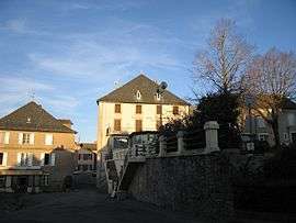 A view within Rieupeyroux | ||
| ||
 Rieupeyroux Location within Occitanie region  Rieupeyroux | ||
| Coordinates: 44°18′31″N 2°14′14″E / 44.3086°N 2.2372°ECoordinates: 44°18′31″N 2°14′14″E / 44.3086°N 2.2372°E | ||
| Country | France | |
| Region | Occitanie | |
| Department | Aveyron | |
| Arrondissement | Villefranche-de-Rouergue | |
| Canton | Aveyron et Tarn | |
| Intercommunality | Aveyron Ségala Viaur | |
| Government | ||
| • Mayor (2008–2014) | Michel Soulie | |
| Area1 | 54.81 km2 (21.16 sq mi) | |
| Population (2008)2 | 2,078 | |
| • Density | 38/km2 (98/sq mi) | |
| Time zone | UTC+1 (CET) | |
| • Summer (DST) | UTC+2 (CEST) | |
| INSEE/Postal code | 12198 /12240 | |
| Elevation |
390–804 m (1,280–2,638 ft) (avg. 720 m or 2,360 ft) | |
|
1 French Land Register data, which excludes lakes, ponds, glaciers > 1 km2 (0.386 sq mi or 247 acres) and river estuaries. 2 Population without double counting: residents of multiple communes (e.g., students and military personnel) only counted once. | ||
.svg.png)
Rieupeyroux (Occitan: Riupeirós) is a commune in the Aveyron department in southern France.
Population
| Historical population | ||
|---|---|---|
| Year | Pop. | ±% |
| 1962 | 2,401 | — |
| 1968 | 2,492 | +3.8% |
| 1975 | 2,524 | +1.3% |
| 1982 | 2,556 | +1.3% |
| 1990 | 2,348 | −8.1% |
| 1999 | 2,157 | −8.1% |
| 2008 | 2,078 | −3.7% |
See also
References
External links
| Wikimedia Commons has media related to Rieupeyroux. |
This article is issued from
Wikipedia.
The text is licensed under Creative Commons - Attribution - Sharealike.
Additional terms may apply for the media files.