Lapanouse-de-Cernon
| Lapanouse-de-Cernon | |
|---|---|
| Commune | |
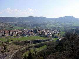 A general view of Lapanouse-de-Cernon | |
 Lapanouse-de-Cernon Location within Occitanie region  Lapanouse-de-Cernon | |
| Coordinates: 43°59′48″N 3°05′54″E / 43.9967°N 3.0983°ECoordinates: 43°59′48″N 3°05′54″E / 43.9967°N 3.0983°E | |
| Country | France |
| Region | Occitanie |
| Department | Aveyron |
| Arrondissement | Millau |
| Canton | Causses-Rougiers |
| Intercommunality | Larzac-Templier Causses et Vallées |
| Government | |
| • Mayor (2008–2014) | Alain Boudes |
| Area1 | 22.87 km2 (8.83 sq mi) |
| Population (2008)2 | 118 |
| • Density | 5.2/km2 (13/sq mi) |
| Time zone | UTC+1 (CET) |
| • Summer (DST) | UTC+2 (CEST) |
| INSEE/Postal code | 12122 /12230 |
| Elevation |
473–880 m (1,552–2,887 ft) (avg. 520 m or 1,710 ft) |
|
1 French Land Register data, which excludes lakes, ponds, glaciers > 1 km2 (0.386 sq mi or 247 acres) and river estuaries. 2 Population without double counting: residents of multiple communes (e.g., students and military personnel) only counted once. | |
Lapanouse-de-Cernon is a commune in the Aveyron department in southern France.
Population
| Historical population | ||
|---|---|---|
| Year | Pop. | ±% |
| 1962 | 124 | — |
| 1968 | 152 | +22.6% |
| 1975 | 130 | −14.5% |
| 1982 | 142 | +9.2% |
| 1990 | 111 | −21.8% |
| 1999 | 99 | −10.8% |
| 2008 | 118 | +19.2% |
See also
References
| Wikimedia Commons has media related to Lapanouse-de-Cernon. |
This article is issued from
Wikipedia.
The text is licensed under Creative Commons - Attribution - Sharealike.
Additional terms may apply for the media files.