Saint-André-de-Najac
| Saint-André-de-Najac | |
|---|---|
| Commune | |
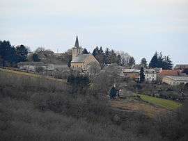 A general view of Saint-André-de-Najac | |
 Saint-André-de-Najac Location within Occitanie region  Saint-André-de-Najac | |
| Coordinates: 44°11′26″N 2°02′28″E / 44.1906°N 2.0411°ECoordinates: 44°11′26″N 2°02′28″E / 44.1906°N 2.0411°E | |
| Country | France |
| Region | Occitanie |
| Department | Aveyron |
| Arrondissement | Villefranche-de-Rouergue |
| Canton | Aveyron et Tarn |
| Government | |
| • Mayor (2008–2014) | André Dalet |
| Area1 | 25.1 km2 (9.7 sq mi) |
| Population (2008)2 | 418 |
| • Density | 17/km2 (43/sq mi) |
| Time zone | UTC+1 (CET) |
| • Summer (DST) | UTC+2 (CEST) |
| INSEE/Postal code | 12210 /12270 |
| Elevation |
150–437 m (492–1,434 ft) (avg. 374 m or 1,227 ft) |
|
1 French Land Register data, which excludes lakes, ponds, glaciers > 1 km2 (0.386 sq mi or 247 acres) and river estuaries. 2 Population without double counting: residents of multiple communes (e.g., students and military personnel) only counted once. | |
Saint-André-de-Najac is a commune in the Aveyron department in southern France.
Population
| Historical population | ||
|---|---|---|
| Year | Pop. | ±% |
| 1962 | 475 | — |
| 1968 | 550 | +15.8% |
| 1975 | 540 | −1.8% |
| 1982 | 509 | −5.7% |
| 1990 | 426 | −16.3% |
| 1999 | 373 | −12.4% |
| 2008 | 418 | +12.1% |
Inhabitants are called Saint-Andréens.
See also
References
External links
| Wikimedia Commons has media related to Saint-André-de-Najac. |
This article is issued from
Wikipedia.
The text is licensed under Creative Commons - Attribution - Sharealike.
Additional terms may apply for the media files.