Entraygues-sur-Truyère
| Entraygues-sur-Truyère | ||
|---|---|---|
| Commune | ||
 Entraygues and the Truyère River | ||
| ||
 Entraygues-sur-Truyère Location within Occitanie region  Entraygues-sur-Truyère | ||
| Coordinates: 44°38′50″N 2°34′03″E / 44.6472°N 2.5675°ECoordinates: 44°38′50″N 2°34′03″E / 44.6472°N 2.5675°E | ||
| Country | France | |
| Region | Occitanie | |
| Department | Aveyron | |
| Arrondissement | Rodez | |
| Canton | Lot et Truyère | |
| Government | ||
| • Mayor (2008–2014) | Fernand Nicolau | |
| Area1 | 30.15 km2 (11.64 sq mi) | |
| Population (2008)2 | 1,171 | |
| • Density | 39/km2 (100/sq mi) | |
| Time zone | UTC+1 (CET) | |
| • Summer (DST) | UTC+2 (CEST) | |
| INSEE/Postal code | 12094 /12140 | |
| Elevation |
222–744 m (728–2,441 ft) (avg. 220 m or 720 ft) | |
|
1 French Land Register data, which excludes lakes, ponds, glaciers > 1 km2 (0.386 sq mi or 247 acres) and river estuaries. 2 Population without double counting: residents of multiple communes (e.g., students and military personnel) only counted once. | ||
.svg.png)
Entraygues-sur-Truyère (Occitan: Entraigas) is a commune in the Aveyron department in southern France.
Geography
The village is located 600 km (370 mi) from Paris and 200 km (120 mi) from Toulouse.
Population
| Historical population | ||
|---|---|---|
| Year | Pop. | ±% |
| 1962 | 1,434 | — |
| 1968 | 1,508 | +5.2% |
| 1975 | 1,510 | +0.1% |
| 1982 | 1,523 | +0.9% |
| 1990 | 1,495 | −1.8% |
| 1999 | 1,267 | −15.3% |
| 2008 | 1,171 | −7.6% |
Transportation
Entraygues-sur-Truyère can be reached by bus from Aurillac (48 km) and from the industrial center of Rodez (55 km). The nearest train station and airport are located in Aurillac or Rodez.
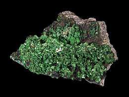
Torbernite from the Margabal Mine, Entraygues-sur-Truyère. Size: 15.3 x 9.6 x 5.6 cm.
See also
References
External links
| Wikimedia Commons has media related to Entraygues-sur-Truyère. |
This article is issued from
Wikipedia.
The text is licensed under Creative Commons - Attribution - Sharealike.
Additional terms may apply for the media files.