Mélagues
| Mélagues | |
|---|---|
| Commune | |
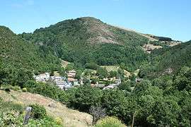 A general view of Mélagues | |
 Mélagues Location within Occitanie region  Mélagues | |
| Coordinates: 43°44′25″N 3°01′06″E / 43.7403°N 3.0183°ECoordinates: 43°44′25″N 3°01′06″E / 43.7403°N 3.0183°E | |
| Country | France |
| Region | Occitanie |
| Department | Aveyron |
| Arrondissement | Millau |
| Canton | Causses-Rougiers |
| Intercommunality | Rougier de Camarès |
| Government | |
| • Mayor (2008–2014) | Jean Milesi |
| Area1 | 44.51 km2 (17.19 sq mi) |
| Population (2008)2 | 66 |
| • Density | 1.5/km2 (3.8/sq mi) |
| Time zone | UTC+1 (CET) |
| • Summer (DST) | UTC+2 (CEST) |
| INSEE/Postal code | 12143 /12360 |
| Elevation |
554–1,067 m (1,818–3,501 ft) (avg. 680 m or 2,230 ft) |
|
1 French Land Register data, which excludes lakes, ponds, glaciers > 1 km2 (0.386 sq mi or 247 acres) and river estuaries. 2 Population without double counting: residents of multiple communes (e.g., students and military personnel) only counted once. | |
Mélagues is a commune in the Aveyron department in southern France.
Population
| Historical population | ||
|---|---|---|
| Year | Pop. | ±% |
| 1962 | 138 | — |
| 1968 | 107 | −22.5% |
| 1975 | 113 | +5.6% |
| 1982 | 94 | −16.8% |
| 1990 | 106 | +12.8% |
| 1999 | 102 | −3.8% |
| 2008 | 66 | −35.3% |
See also
References
| Wikimedia Commons has media related to Mélagues. |
This article is issued from
Wikipedia.
The text is licensed under Creative Commons - Attribution - Sharealike.
Additional terms may apply for the media files.