Saint-Juéry, Aveyron
| Saint-Juéry | |
|---|---|
| Commune | |
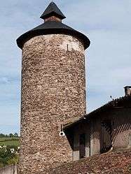 The tower of Avalats | |
 Saint-Juéry Location within Occitanie region  Saint-Juéry | |
| Coordinates: 43°54′39″N 2°41′47″E / 43.9108°N 2.6964°ECoordinates: 43°54′39″N 2°41′47″E / 43.9108°N 2.6964°E | |
| Country | France |
| Region | Occitanie |
| Department | Aveyron |
| Arrondissement | Millau |
| Canton | Causses-Rougiers |
| Intercommunality | Sept Vallons |
| Government | |
| • Mayor (2008–2014) | Christian Font |
| Area1 | 29.01 km2 (11.20 sq mi) |
| Population (2008)2 | 224 |
| • Density | 7.7/km2 (20/sq mi) |
| Time zone | UTC+1 (CET) |
| • Summer (DST) | UTC+2 (CEST) |
| INSEE/Postal code | 12233 /12550 |
| Elevation |
289–637 m (948–2,090 ft) (avg. 500 m or 1,600 ft) |
|
1 French Land Register data, which excludes lakes, ponds, glaciers > 1 km2 (0.386 sq mi or 247 acres) and river estuaries. 2 Population without double counting: residents of multiple communes (e.g., students and military personnel) only counted once. | |
Saint-Juéry is a commune in the Aveyron department in southern France.
Population
| Historical population | ||
|---|---|---|
| Year | Pop. | ±% |
| 1962 | 340 | — |
| 1968 | 396 | +16.5% |
| 1975 | 356 | −10.1% |
| 1982 | 322 | −9.6% |
| 1990 | 290 | −9.9% |
| 1999 | 257 | −11.4% |
| 2008 | 224 | −12.8% |
See also
References
| Wikimedia Commons has media related to Saint-Juéry (Aveyron). |
This article is issued from
Wikipedia.
The text is licensed under Creative Commons - Attribution - Sharealike.
Additional terms may apply for the media files.