Toulonjac
| Toulonjac | |
|---|---|
| Commune | |
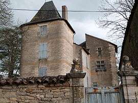 The chateau in Toulonjac | |
 Toulonjac Location within Occitanie region  Toulonjac | |
| Coordinates: 44°22′57″N 2°00′05″E / 44.3825°N 2.0014°ECoordinates: 44°22′57″N 2°00′05″E / 44.3825°N 2.0014°E | |
| Country | France |
| Region | Occitanie |
| Department | Aveyron |
| Arrondissement | Villefranche-de-Rouergue |
| Canton | Villeneuvois et Villefranchois |
| Intercommunality | Villefranchois |
| Government | |
| • Mayor (2008–2014) | Jean-Louis Alcouffe |
| Area1 | 7.25 km2 (2.80 sq mi) |
| Population (2008)2 | 705 |
| • Density | 97/km2 (250/sq mi) |
| Time zone | UTC+1 (CET) |
| • Summer (DST) | UTC+2 (CEST) |
| INSEE/Postal code | 12281 /12200 |
| Elevation |
288–441 m (945–1,447 ft) (avg. 306 m or 1,004 ft) |
|
1 French Land Register data, which excludes lakes, ponds, glaciers > 1 km2 (0.386 sq mi or 247 acres) and river estuaries. 2 Population without double counting: residents of multiple communes (e.g., students and military personnel) only counted once. | |
Toulonjac is a commune in the Aveyron department in southern France.
Population
| Historical population | ||
|---|---|---|
| Year | Pop. | ±% |
| 1962 | 237 | — |
| 1968 | 328 | +38.4% |
| 1975 | 442 | +34.8% |
| 1982 | 531 | +20.1% |
| 1990 | 668 | +25.8% |
| 1999 | 642 | −3.9% |
| 2008 | 705 | +9.8% |
See also
References
| Wikimedia Commons has media related to Toulonjac. |
This article is issued from
Wikipedia.
The text is licensed under Creative Commons - Attribution - Sharealike.
Additional terms may apply for the media files.