Viala-du-Pas-de-Jaux
| Viala-du-Pas-de-Jaux | |
|---|---|
| Commune | |
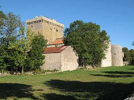 The tower in Viala-du-Pas-de-Jaux | |
 Viala-du-Pas-de-Jaux Location within Occitanie region  Viala-du-Pas-de-Jaux | |
| Coordinates: 43°57′27″N 3°03′23″E / 43.9575°N 3.0564°ECoordinates: 43°57′27″N 3°03′23″E / 43.9575°N 3.0564°E | |
| Country | France |
| Region | Occitanie |
| Department | Aveyron |
| Arrondissement | Millau |
| Canton | Causses-Rougiers |
| Intercommunality | Larzac-Templier Causses et Vallées |
| Government | |
| • Mayor (2008–2014) | Nicole Chaudesaygues |
| Area1 | 18.95 km2 (7.32 sq mi) |
| Population (2008)2 | 104 |
| • Density | 5.5/km2 (14/sq mi) |
| Time zone | UTC+1 (CET) |
| • Summer (DST) | UTC+2 (CEST) |
| INSEE/Postal code | 12295 /12250 |
| Elevation |
720–879 m (2,362–2,884 ft) (avg. 810 m or 2,660 ft) |
|
1 French Land Register data, which excludes lakes, ponds, glaciers > 1 km2 (0.386 sq mi or 247 acres) and river estuaries. 2 Population without double counting: residents of multiple communes (e.g., students and military personnel) only counted once. | |
Viala-du-Pas-de-Jaux is a commune in the Aveyron department in the Occitanie region in southern France.
Population
| Historical population | ||
|---|---|---|
| Year | Pop. | ±% |
| 1962 | 97 | — |
| 1968 | 100 | +3.1% |
| 1975 | 80 | −20.0% |
| 1982 | 87 | +8.7% |
| 1990 | 85 | −2.3% |
| 1999 | 74 | −12.9% |
| 2008 | 104 | +40.5% |
See also
References
| Wikimedia Commons has media related to Viala-du-Pas-de-Jaux. |
This article is issued from
Wikipedia.
The text is licensed under Creative Commons - Attribution - Sharealike.
Additional terms may apply for the media files.