Estaing, Aveyron
| Estaing | ||
|---|---|---|
| Commune | ||
 Estaing and the River Lot | ||
| ||
 Estaing Location within Occitanie region  Estaing | ||
| Coordinates: 44°33′22″N 2°40′21″E / 44.5561°N 2.6725°ECoordinates: 44°33′22″N 2°40′21″E / 44.5561°N 2.6725°E | ||
| Country | France | |
| Region | Occitanie | |
| Department | Aveyron | |
| Arrondissement | Rodez | |
| Canton | Lot et Truyère | |
| Government | ||
| • Mayor (2008–2014) | Jean Pradalier | |
| Area1 | 16.96 km2 (6.55 sq mi) | |
| Population (2008)2 | 607 | |
| • Density | 36/km2 (93/sq mi) | |
| Time zone | UTC+1 (CET) | |
| • Summer (DST) | UTC+2 (CEST) | |
| INSEE/Postal code | 12098 /12190 | |
| Elevation |
301–760 m (988–2,493 ft) (avg. 300 m or 980 ft) | |
|
1 French Land Register data, which excludes lakes, ponds, glaciers > 1 km2 (0.386 sq mi or 247 acres) and river estuaries. 2 Population without double counting: residents of multiple communes (e.g., students and military personnel) only counted once. | ||

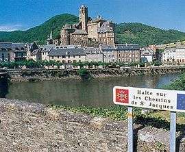
Estaing (Occitan: Estanh) is a commune in the Aveyron department in southern France.
Located in the north of the Aveyron department in the Occitanie region, Estaing is considered as one of the most picturesque villages in France. The village is very quiet during the winter months; it is in the summer that the village shows the most signs of life. Lying at 320 metres above sea level, the winters are cool and the summers are hot and dry. Espalion is a ten-minute drive away, while Rodez is about 50 minutes away.
The bridge over the Lot in Estaing is part of the World Heritage Sites of the Routes of Santiago de Compostela in France.
Population
| Historical population | ||
|---|---|---|
| Year | Pop. | ±% |
| 1962 | 627 | — |
| 1968 | 718 | +14.5% |
| 1975 | 667 | −7.1% |
| 1982 | 666 | −0.1% |
| 1990 | 665 | −0.2% |
| 1999 | 612 | −8.0% |
| 2008 | 607 | −0.8% |
See also
References
| Wikimedia Commons has media related to Estaing (Aveyron). |