Bozouls
| Bozouls | ||
|---|---|---|
| Commune | ||
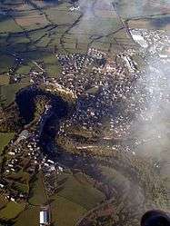 An aerial view of Bozouls | ||
| ||
 Bozouls Location within Occitanie region  Bozouls | ||
| Coordinates: 44°28′17″N 2°43′17″E / 44.4714°N 2.7214°ECoordinates: 44°28′17″N 2°43′17″E / 44.4714°N 2.7214°E | ||
| Country | France | |
| Region | Occitanie | |
| Department | Aveyron | |
| Arrondissement | Rodez | |
| Canton | Causse-Comtal | |
| Intercommunality | Bozouls Comtal | |
| Government | ||
| • Mayor (2008–2014) | Jean-Luc Calmelly | |
| Area1 | 69.69 km2 (26.91 sq mi) | |
| Population (2008)2 | 2,772 | |
| • Density | 40/km2 (100/sq mi) | |
| Time zone | UTC+1 (CET) | |
| • Summer (DST) | UTC+2 (CEST) | |
| INSEE/Postal code | 12033 /12340 | |
| Elevation |
355–711 m (1,165–2,333 ft) (avg. 640 m or 2,100 ft) | |
|
1 French Land Register data, which excludes lakes, ponds, glaciers > 1 km2 (0.386 sq mi or 247 acres) and river estuaries. 2 Population without double counting: residents of multiple communes (e.g., students and military personnel) only counted once. | ||
.svg.png)
Bozouls (Occitan: Boason) is a commune in the Aveyron department in southern France.
It is located on Route Maquis de Jean Pierre (D20) thirty minutes from Rodez, one hour from the Gorges du Tarn, two hours northeast of Toulouse, and six and a half hours due south of Paris.
Population
| Historical population | ||
|---|---|---|
| Year | Pop. | ±% |
| 1990 | 2,060 | — |
| 1999 | 2,230 | +8.3% |
| 2008 | 2,772 | +24.3% |
See also
References
External links
| Wikimedia Commons has media related to Bozouls. |
This article is issued from
Wikipedia.
The text is licensed under Creative Commons - Attribution - Sharealike.
Additional terms may apply for the media files.