Ambeyrac
| Ambeyrac | |
|---|---|
| Commune | |
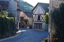 A street in Ambeyrac | |
 Ambeyrac Location within Occitanie region  Ambeyrac | |
| Coordinates: 44°30′38″N 1°56′41″E / 44.5106°N 1.9447°ECoordinates: 44°30′38″N 1°56′41″E / 44.5106°N 1.9447°E | |
| Country | France |
| Region | Occitanie |
| Department | Aveyron |
| Arrondissement | Villefranche-de-Rouergue |
| Canton | Villeneuvois et Villefranchois |
| Intercommunality | Grand Villefranchois |
| Government | |
| • Mayor (2014-2020) | Marie-Thérèse Chapeau |
| Area1 | 11.24 km2 (4.34 sq mi) |
| Population (2014)2 | 179 |
| • Density | 16/km2 (41/sq mi) |
| Time zone | UTC+1 (CET) |
| • Summer (DST) | UTC+2 (CEST) |
| INSEE/Postal code | 12007 /12260 |
| Elevation |
141–344 m (463–1,129 ft) (avg. 163 m or 535 ft) |
|
1 French Land Register data, which excludes lakes, ponds, glaciers > 1 km2 (0.386 sq mi or 247 acres) and river estuaries. 2 Population without double counting: residents of multiple communes (e.g., students and military personnel) only counted once. | |
Ambeyrac is a commune in the Aveyron department in the Occitanie region of southern France.
The inhabitants of the commune are known as Ambairacois or Ambairacoises[1]
Geography
Ambeyrac is located some 15 km south-west of Figeac and 25 km north-west of Villefranche-de-Rouergue with its northern border being the border between the departments of Aveyron and Lot. It can be accessed by the D86 road from Balaguier-d'Olt in the north-east which passes through the village and continues south to La Capelle-Balaguier. The minor D127 road also goes west from the village to Saujac.[2]
The northern border of the commune is formed entirely by the Lot river for which there are no crossing points in the commune. The Ruisseau de Flaucou flows from the south through the commune and the village to join the Lot.[2]
Neighbouring communes and villages[2]
Places adjacent to Ambeyrac | |
|---|---|
Administration
List of Successive Mayors[3]
| From | To | Name | Party | Position |
|---|---|---|---|---|
| 2001 | 2009 | Roland Théron | ||
| 2009 | 2014 | Émilie Cazajus | ||
| 2014 | 2020 | Marie-Thérèse Chapeau |
(Not all data is known)
Due to the death of Roland Théron, Émilie Cazajus was elected Mayor in 2009.
Demography
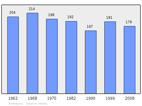
In 2010 the commune had 182 inhabitants. The evolution of the number of inhabitants is known through the population censuses conducted in the commune since 1793. From the 21st century, a census of communes with fewer than 10,000 inhabitants is held every five years, unlike larger towns that have a sample survey every year.[Note 1]
| 1793 | 1800 | 1806 | 1821 | 1831 | 1836 | 1841 | 1846 | 1851 |
|---|---|---|---|---|---|---|---|---|
| 352 | 339 | - | - | - | - | - | - | - |
| 1856 | 1861 | 1866 | 1872 | 1876 | 1881 | 1886 | 1891 | 1896 |
|---|---|---|---|---|---|---|---|---|
| - | - | - | - | - | - | 543 | 527 | 516 |
| 1901 | 1906 | 1911 | 1921 | 1926 | 1931 | 1936 | 1946 | 1954 |
|---|---|---|---|---|---|---|---|---|
| 520 | 472 | 456 | 349 | 343 | 327 | 319 | 252 | 217 |
| 1962 | 1968 | 1975 | 1982 | 1990 | 1999 | 2006 | 2010 | - |
|---|---|---|---|---|---|---|---|---|
| 204 | 214 | 198 | 192 | 167 | 191 | 187 | 182 | - |
Sources : Ldh/EHESS/Cassini until 1962, INSEE database from 1968 (population without double counting and municipal population from 2006)
Sites and monuments

- The Chateau of Camboulan (16th century)

- A Tithe barn has been converted into a hall with two levels.
- Church Interior
 Church Interior
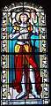 Stained Glass - Joan of Arc
 Stained Glass - Virgin and child
See also
Bibliography
- Christian-Pierre Bedel (preface by Raymond Audouard), Vilanòva: Ambairac, La Capèla, Montsalés, Òls, Sanch-Igèst, Santa-Crotz, Sent-Remèsi, Sauvanhac, Saujac / Christian-Pierre Bedel e los estatjants del canton de Vilanòva, Rodez, Mission départementale de la culture, coll. Al canton, 1995, ill., cov. ill. 28 cm, 247 p. ( ISBN 2-907279-23-8, ISSN 1151-8375, BnF FRBNF36688568) (in French)
External links
- Ambeyrac on the National Geographic Institute website (in French)
- Ambeyrac on the Community of communes of Villeneuvois, Diège et Lot website (in French)
- Ambeyrac on Lion1906
- Ambeyrac on Google Maps
- Ambeyrac on Géoportail, National Geographic Institute (IGN) website (in French)
- Ambayrac on the 1750 Cassini Map
- Ambeyrac on the INSEE website (in French)
- INSEE (in French)
Notes and references
Notes
- ↑ At the beginning of the 21st century, the methods of identification have been modified by law No. 2002-276 of 27 February 2002 Archived 2016-03-06 at the Wayback Machine., the so-called "law of local democracy" and in particular Title V "census operations" which allow, after a transitional period running from 2004 to 2008, the annual publication of the legal population of the different French administrative districts. For communes with a population greater than 10,000 inhabitants, a sample survey is conducted annually, the entire territory of these communes is taken into account at the end of the period of five years. The first "legal population" after 1999 under this new law came into force on 1 January 2009 and was based on the census of 2006.
References
- ↑ Inhabitants of Aveyron (in French)
- 1 2 3 Google Maps
- ↑ List of Mayors of France
- ↑ Ministry of Culture, Mérimée PA00135441 Chateau of Camboulan (in French)
| Wikimedia Commons has media related to Ambeyrac. |