Vézins-de-Lévézou
| Vézins-de-Lévézou | ||
|---|---|---|
| Commune | ||
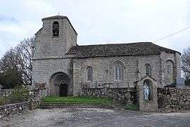 The church in Vézins-de-Lévézou | ||
| ||
 Vézins-de-Lévézou Location within Occitanie region  Vézins-de-Lévézou | ||
| Coordinates: 44°16′48″N 2°57′12″E / 44.28°N 2.9533°ECoordinates: 44°16′48″N 2°57′12″E / 44.28°N 2.9533°E | ||
| Country | France | |
| Region | Occitanie | |
| Department | Aveyron | |
| Arrondissement | Millau | |
| Canton | Raspes et Lévezou | |
| Intercommunality | Lévézou Pareloup | |
| Government | ||
| • Mayor (2008–2014) | Arnaud Viala | |
| Area1 | 78.96 km2 (30.49 sq mi) | |
| Population (2008)2 | 645 | |
| • Density | 8.2/km2 (21/sq mi) | |
| Time zone | UTC+1 (CET) | |
| • Summer (DST) | UTC+2 (CEST) | |
| INSEE/Postal code | 12294 /12780 | |
| Elevation |
713–1,155 m (2,339–3,789 ft) (avg. 900 m or 3,000 ft) | |
|
1 French Land Register data, which excludes lakes, ponds, glaciers > 1 km2 (0.386 sq mi or 247 acres) and river estuaries. 2 Population without double counting: residents of multiple communes (e.g., students and military personnel) only counted once. | ||

Vézins-de-Lévézou is a commune in the Aveyron department in southern France.
The Château de Vezins is a historical castle. The first fortress was built in 1120 by Vesian de Vezins to command the Lévezou district. Following a disastrous fire in 1642, the only remains of this original castle are the vaulted rooms of the ground floor. The castle was redeveloped in the Renaissance style.
Population
| Historical population | ||
|---|---|---|
| Year | Pop. | ±% |
| 1962 | 963 | — |
| 1968 | 1,004 | +4.3% |
| 1975 | 879 | −12.5% |
| 1982 | 809 | −8.0% |
| 1990 | 699 | −13.6% |
| 1999 | 634 | −9.3% |
| 2008 | 645 | +1.7% |
See also
References
| Wikimedia Commons has media related to Vézins-de-Lévézou. |
This article is issued from
Wikipedia.
The text is licensed under Creative Commons - Attribution - Sharealike.
Additional terms may apply for the media files.