Sainte-Croix, Aveyron
| Sainte-Croix | |
|---|---|
| Commune | |
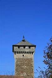 Clock tower | |
 Sainte-Croix Location within Occitanie region  Sainte-Croix | |
| Coordinates: 44°25′38″N 1°58′05″E / 44.4272°N 1.9681°ECoordinates: 44°25′38″N 1°58′05″E / 44.4272°N 1.9681°E | |
| Country | France |
| Region | Occitanie |
| Department | Aveyron |
| Arrondissement | Villefranche-de-Rouergue |
| Canton | Villeneuvois et Villefranchois |
| Intercommunality | Villeneuvois, Diège et Lot |
| Government | |
| • Mayor (2008–2014) | Raymond Bonestèbe |
| Area1 | 25.88 km2 (9.99 sq mi) |
| Population (2008)2 | 719 |
| • Density | 28/km2 (72/sq mi) |
| Time zone | UTC+1 (CET) |
| • Summer (DST) | UTC+2 (CEST) |
| INSEE/Postal code | 12217 /12260 |
| Elevation |
312–441 m (1,024–1,447 ft) (avg. 400 m or 1,300 ft) |
|
1 French Land Register data, which excludes lakes, ponds, glaciers > 1 km2 (0.386 sq mi or 247 acres) and river estuaries. 2 Population without double counting: residents of multiple communes (e.g., students and military personnel) only counted once. | |
Sainte-Croix is a commune in the Aveyron department in southern France.
Population
| Historical population | ||
|---|---|---|
| Year | Pop. | ±% |
| 1962 | 481 | — |
| 1968 | 539 | +12.1% |
| 1975 | 541 | +0.4% |
| 1982 | 601 | +11.1% |
| 1990 | 608 | +1.2% |
| 1999 | 632 | +3.9% |
| 2008 | 719 | +13.8% |
See also
References
| Wikimedia Commons has media related to Sainte-Croix (Aveyron). |
This article is issued from
Wikipedia.
The text is licensed under Creative Commons - Attribution - Sharealike.
Additional terms may apply for the media files.