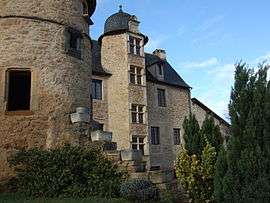
Valzergues
| Valzergues | |
|---|---|
| Commune | |
 Town hall | |
 Valzergues Location within Occitanie region  Valzergues | |
| Coordinates: 44°30′00″N 2°13′20″E / 44.5°N 2.2222°ECoordinates: 44°30′00″N 2°13′20″E / 44.5°N 2.2222°E | |
| Country | France |
| Region | Occitanie |
| Department | Aveyron |
| Arrondissement | Villefranche-de-Rouergue |
| Canton | Lot et Montbazinois |
| Intercommunality | Plateau de Montbazens |
| Government | |
| • Mayor (2008–2014) | Didier Foissac |
| Area1 | 6.49 km2 (2.51 sq mi) |
| Population (2008)2 | 202 |
| • Density | 31/km2 (81/sq mi) |
| Time zone | UTC+1 (CET) |
| • Summer (DST) | UTC+2 (CEST) |
| INSEE/Postal code | 12289 /12220 |
| Elevation |
261–468 m (856–1,535 ft) (avg. 450 m or 1,480 ft) |
|
1 French Land Register data, which excludes lakes, ponds, glaciers > 1 km2 (0.386 sq mi or 247 acres) and river estuaries. 2 Population without double counting: residents of multiple communes (e.g., students and military personnel) only counted once. | |
Valzergues is a commune in the Aveyron department in southern France.
Population
| Historical population | ||
|---|---|---|
| Year | Pop. | ±% |
| 1962 | 255 | — |
| 1968 | 262 | +2.7% |
| 1975 | 223 | −14.9% |
| 1982 | 225 | +0.9% |
| 1990 | 216 | −4.0% |
| 1999 | 203 | −6.0% |
| 2008 | 202 | −0.5% |
See also
References
| Wikimedia Commons has media related to Valzergues. |
This article is issued from
Wikipedia.
The text is licensed under Creative Commons - Attribution - Sharealike.
Additional terms may apply for the media files.