Canet-de-Salars
| Canet-de-Salars | |
|---|---|
| Commune | |
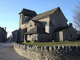 The church in Canet-de-Salars | |
 Canet-de-Salars Location within Occitanie region  Canet-de-Salars | |
| Coordinates: 44°14′11″N 2°45′18″E / 44.2364°N 2.755°ECoordinates: 44°14′11″N 2°45′18″E / 44.2364°N 2.755°E | |
| Country | France |
| Region | Occitanie |
| Department | Aveyron |
| Arrondissement | Millau |
| Canton | Raspes et Lévezou |
| Intercommunality | Lévézou Pareloup |
| Government | |
| • Mayor (2008–2014) | Patrick Géraud |
| Area1 | 29.97 km2 (11.57 sq mi) |
| Population (2008)2 | 410 |
| • Density | 14/km2 (35/sq mi) |
| Time zone | UTC+1 (CET) |
| • Summer (DST) | UTC+2 (CEST) |
| INSEE/Postal code | 12050 /12290 |
| Elevation |
713–870 m (2,339–2,854 ft) (avg. 850 m or 2,790 ft) |
|
1 French Land Register data, which excludes lakes, ponds, glaciers > 1 km2 (0.386 sq mi or 247 acres) and river estuaries. 2 Population without double counting: residents of multiple communes (e.g., students and military personnel) only counted once. | |
Canet-de-Salars is a commune in the Aveyron department in southern France.
Population
| Historical population | ||
|---|---|---|
| Year | Pop. | ±% |
| 1962 | 419 | — |
| 1968 | 510 | +21.7% |
| 1975 | 485 | −4.9% |
| 1982 | 440 | −9.3% |
| 1990 | 440 | +0.0% |
| 1999 | 379 | −13.9% |
| 2008 | 410 | +8.2% |
See also
References
| Wikimedia Commons has media related to Canet-de-Salars. |
This article is issued from
Wikipedia.
The text is licensed under Creative Commons - Attribution - Sharealike.
Additional terms may apply for the media files.