Marcillac-Vallon
| Marcillac-Vallon | ||
|---|---|---|
| Commune | ||
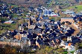 A general view of Marcillac-Vallon | ||
| ||
 Marcillac-Vallon Location within Occitanie region  Marcillac-Vallon | ||
| Coordinates: 44°28′29″N 2°27′55″E / 44.4747°N 2.4653°ECoordinates: 44°28′29″N 2°27′55″E / 44.4747°N 2.4653°E | ||
| Country | France | |
| Region | Occitanie | |
| Department | Aveyron | |
| Arrondissement | Rodez | |
| Canton | Vallon | |
| Intercommunality | Causse et Vallon de Marcillac | |
| Government | ||
| • Mayor (2008–2014) | Jacques Raynal | |
| Area1 | 14.59 km2 (5.63 sq mi) | |
| Population (2008)2 | 1,680 | |
| • Density | 120/km2 (300/sq mi) | |
| Time zone | UTC+1 (CET) | |
| • Summer (DST) | UTC+2 (CEST) | |
| INSEE/Postal code | 12138 /12330 | |
| Elevation |
275–534 m (902–1,752 ft) (avg. 275 m or 902 ft) | |
|
1 French Land Register data, which excludes lakes, ponds, glaciers > 1 km2 (0.386 sq mi or 247 acres) and river estuaries. 2 Population without double counting: residents of multiple communes (e.g., students and military personnel) only counted once. | ||
.svg.png)
Marcillac-Vallon is a commune in the Aveyron department in southern France.
Population
| Historical population | ||
|---|---|---|
| Year | Pop. | ±% |
| 1962 | 1,184 | — |
| 1968 | 1,370 | +15.7% |
| 1975 | 1,493 | +9.0% |
| 1982 | 1,564 | +4.8% |
| 1990 | 1,485 | −5.1% |
| 1999 | 1,532 | +3.2% |
| 2008 | 1,680 | +9.7% |
See also
References
| Wikimedia Commons has media related to Marcillac-Vallon. |
This article is issued from
Wikipedia.
The text is licensed under Creative Commons - Attribution - Sharealike.
Additional terms may apply for the media files.