Gissac
| Gissac | |
|---|---|
| Commune | |
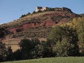 Château de Montaigut | |
 Gissac Location within Occitanie region  Gissac | |
| Coordinates: 43°50′50″N 2°55′57″E / 43.8472°N 2.9325°ECoordinates: 43°50′50″N 2°55′57″E / 43.8472°N 2.9325°E | |
| Country | France |
| Region | Occitanie |
| Department | Aveyron |
| Arrondissement | Millau |
| Canton | Causses-Rougiers |
| Intercommunality | Rougier de Camarès |
| Government | |
| • Mayor (2008–2014) | Roger Cremien |
| Area1 | 31.02 km2 (11.98 sq mi) |
| Population (2008)2 | 114 |
| • Density | 3.7/km2 (9.5/sq mi) |
| Time zone | UTC+1 (CET) |
| • Summer (DST) | UTC+2 (CEST) |
| INSEE/Postal code | 12109 /12360 |
| Elevation |
351–769 m (1,152–2,523 ft) (avg. 550 m or 1,800 ft) |
|
1 French Land Register data, which excludes lakes, ponds, glaciers > 1 km2 (0.386 sq mi or 247 acres) and river estuaries. 2 Population without double counting: residents of multiple communes (e.g., students and military personnel) only counted once. | |
Gissac is a commune in the Aveyron department in southern France.
The Château de Montaigut is a medieval castle that is open to visitors.
Population
| Historical population | ||
|---|---|---|
| Year | Pop. | ±% |
| 1962 | 138 | — |
| 1968 | 146 | +5.8% |
| 1975 | 117 | −19.9% |
| 1982 | 152 | +29.9% |
| 1990 | 139 | −8.6% |
| 1999 | 97 | −30.2% |
| 2008 | 114 | +17.5% |
See also
References
| Wikimedia Commons has media related to Gissac. |
This article is issued from
Wikipedia.
The text is licensed under Creative Commons - Attribution - Sharealike.
Additional terms may apply for the media files.