Comps-la-Grand-Ville
| Comps-la-Grand-Ville | |
|---|---|
| Commune | |
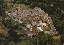 Bonnecombe Abbey | |
 Comps-la-Grand-Ville Location within Occitanie region  Comps-la-Grand-Ville | |
| Coordinates: 44°13′53″N 2°34′05″E / 44.2314°N 2.5681°ECoordinates: 44°13′53″N 2°34′05″E / 44.2314°N 2.5681°E | |
| Country | France |
| Region | Occitanie |
| Department | Aveyron |
| Arrondissement | Millau |
| Canton | Monts du Réquistanais |
| Intercommunality | Cassagnes-Bégonhès |
| Government | |
| • Mayor (2008–2014) | Stéphan Cambon |
| Area1 | 21.95 km2 (8.47 sq mi) |
| Population (2008)2 | 512 |
| • Density | 23/km2 (60/sq mi) |
| Time zone | UTC+1 (CET) |
| • Summer (DST) | UTC+2 (CEST) |
| INSEE/Postal code | 12073 /12120 |
| Elevation |
441–772 m (1,447–2,533 ft) (avg. 705 m or 2,313 ft) |
|
1 French Land Register data, which excludes lakes, ponds, glaciers > 1 km2 (0.386 sq mi or 247 acres) and river estuaries. 2 Population without double counting: residents of multiple communes (e.g., students and military personnel) only counted once. | |
Comps-la-Grand-Ville is a commune in the Aveyron department in southern France.
Population
| Historical population | ||
|---|---|---|
| Year | Pop. | ±% |
| 1962 | 483 | — |
| 1968 | 581 | +20.3% |
| 1975 | 576 | −0.9% |
| 1982 | 542 | −5.9% |
| 1990 | 516 | −4.8% |
| 1999 | 426 | −17.4% |
| 2008 | 512 | +20.2% |
See also
References
| Wikimedia Commons has media related to Comps-la-Grand-Ville. |
This article is issued from
Wikipedia.
The text is licensed under Creative Commons - Attribution - Sharealike.
Additional terms may apply for the media files.