Montrozier
| Montrozier | |
|---|---|
| Commune | |
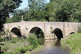 Bridge over the Aveyron | |
 Montrozier Location within Occitanie region  Montrozier | |
| Coordinates: 44°23′38″N 2°42′24″E / 44.3939°N 2.7067°ECoordinates: 44°23′38″N 2°42′24″E / 44.3939°N 2.7067°E | |
| Country | France |
| Region | Occitanie |
| Department | Aveyron |
| Arrondissement | Rodez |
| Canton | Causse-Comtal |
| Intercommunality | Bozouls Comtal |
| Government | |
| • Mayor (2010–2014) | Christophe Méry |
| Area1 | 46.78 km2 (18.06 sq mi) |
| Population (2008)2 | 1,415 |
| • Density | 30/km2 (78/sq mi) |
| Time zone | UTC+1 (CET) |
| • Summer (DST) | UTC+2 (CEST) |
| INSEE/Postal code | 12157 /12630 |
| Elevation |
538–886 m (1,765–2,907 ft) (avg. 650 m or 2,130 ft) |
|
1 French Land Register data, which excludes lakes, ponds, glaciers > 1 km2 (0.386 sq mi or 247 acres) and river estuaries. 2 Population without double counting: residents of multiple communes (e.g., students and military personnel) only counted once. | |
Montrozier (Occitan: Mont Rosièr) is a commune in the Aveyron department in southern France.
Population
| Historical population | ||
|---|---|---|
| Year | Pop. | ±% |
| 1962 | 852 | — |
| 1968 | 942 | +10.6% |
| 1975 | 946 | +0.4% |
| 1982 | 1,081 | +14.3% |
| 1990 | 1,210 | +11.9% |
| 1999 | 1,279 | +5.7% |
| 2008 | 1,415 | +10.6% |
See also
References
| Wikimedia Commons has media related to Montrozier. |
This article is issued from
Wikipedia.
The text is licensed under Creative Commons - Attribution - Sharealike.
Additional terms may apply for the media files.